Wednesday, August 22, 2012

Nikon-roid


Positonal WiFi link - but what else?  Got to get me one of them...

Tuesday, August 21, 2012

ArcGIS -Online and Off-the-tracks?


ArcGIS Online Pricing Released -- What's a Service Credit

 | COMMENTS


ArcGIS Online has been one of the more confusing products to come out of Esri that I can recall (well besides ArcGIS Publisher). No one could really figure out what Esri wanted it to be and then it sort of went dark since late last year. In the mean time, we’ve heard rumblings about the pricing being out of wack with expectations and many smaller government users have basically told me they thought is was very unreasonable. But for most of us, we had no idea what it was going look like or cost. But now we’ve got pricing.


To me that doesn’t look bad at all. In fact I’m almost wondering if Esri is doing this at a loss given what ArcGIS Server costs. Now I do get that there is some uncertainty here with what exactly you are getting with these Service Credits. A good friend of mine compared them to “Disney Dollars” where their value can of course be changed at any time. Right now they are 1:1 to the U.S. Dollar but you still don’t really have much idea what that means. As will all Esri pricing, anything is negotiable so call your local rep and deal with them.

But that doesn’t really explain what a Service Credit is and what you get for it. Anyone have a clue? Some say it is one action of storing data in ArcGIS.com:

If that’s the case, this is a steal and you all need to be more realistic with your pricing expectations. I am quite impressed with how aggressive it is. Clearly Esri is serious about ArcGIS Online. Meanwhile, Google continues to do nothing with Google Earth Maps Builder. I guess we’ll hear more about it at Google I/O, but whatever lead they had over Esri, that’s evaporated.


We want it all... Resistance is futile?

ArcGIS Online is Not the Answer to Every Question from Directions Mag.


I am the first to admit the communications from Esri over the past year or two regarding ArcGIS Online has come down to a single idea. ArcGIS Online is the answer to every question. It addresses data silos, simplifies service publishing, makes map and app creation easy, provides great basemaps, offers free and subscription accounts, unites enterprises and more. The plenary at Esri UC seemed to reinforce this idea. Jack Dangermond’s off-hand comment during the morning session, “You don’t have to buy this, but you should” seemed to seal the vision.

But when you dig a bit deeper and talk with Esri staffers involved in user implementations, they are bit more circumspect. Further, if you fear that committing to a subscription account means you will be left to fend for yourself and burn through your first stack of credits, that’s not the case.

ArcGIS can be the answer to all questions. That is, an organization can host all its data and services in an organizational account and use them to build internal and public facing maps and apps. But, that may not be the best use of resources (aka money). I learned that for some organizations a better implementation might include a local ArcGIS Server implementation that pushes out the services. Those services can be registered with ArcGIS Online and thus be accessible and useable to those who have access (via an account or if they are public). In this implementation, credit use is very low since the local server is “doing all the work.” The credit hits are only for the communication between ArcGIS Online and the local server. This is exactly the scenario reader Kevin shared via e-mail when he suggested that ArcGIS Online may well help push sales of ArcGIS Server.

Esri has worked closely with its beta users to learn how they have implemented ArcGIS Online, the challenges they’ve faced and the solutions they’ve teased out. That information, along with internal testing, form the basis for a series of currently internal, draft docs detailing a stab at best practices.That information, while still in development, is shared with new subscriber organizations. Those organizations can also use a several week trial period where they can monitor ArcGIS Online use and how that use eats up credits.

Esri is also testing a variety of ArcGIS Online organizational implementations for different industries such as local government. The goal is to explore what types of processing are heavily used vs. lightly used and to try to find ways to manage costs. For example, it may be more efficient and less costly to create tile caches locally in ArcGIS, then upload them to ArcGIS Online instead of doing that work in the cloud.

Esri hopes to complete its initial work and formalize some of these guidance documents in the coming months. As more than one Esri staffer pointed out, so much about ArcGIS Online is new, not just the hosting in the cloud but also the subscription and credit models, that teasing out these best practices is not trivial.

ArcGIS Online pricing - what is a Service Credit worth?

Confused about AGOL pricing?  So was I.

I got on the phone with Esri today.   Here is is our Q&A:

ArcGIS Online for Organizations, Level 1 purchase gets "2500 Service Credits".  But what does that mean?

Service credits are expended when ArcGIS Online functionality is deployed.  With the final release, we are providing a dashboard for the administrator, so that they may review how the service credits are being utilized.

Here are some examples:

1)      Service Credits are not used when you upload data or services to your instance of AGOL
2)      Service Credits are not consumed when using a esri basemap service in your application
3)      Service Credits are used when ‘mash’ up a shapefile, map service, table your company/agency uses in a service
4)      Service Credits are used when you create and store a feature service
5)      Service Credits are used when you create or store a tile or geospatial data service(layer, map package)
6)      Service Credits are used when you use a geoprocessing service (i.e. …batch geocodes), others to be added
7)      Service Credits are used when you do data transfer

This info would be more useful if it read "XX [Number of] service credits are used when..."

Here are examples of AGO Credit Consumption

  • Data Transfer – Data transferred out as hosted services or downloading data files
    • 6 credits / 1 GB data
  • Geocodes –
    • 12.5 geocodes / credit
    • 80 credits / 1,000 geocodes
    • 100,000 geocodes / 8000 credits
  • Tile & Data Storage – 1.2 credits per GB of storage per month, 14.4 credits/yr  per GB of data
  • Feature service –
    • 2.4 credits per 10 MB of storage per month, 28.8 credits/yr  per 10 MB
    • 2880 credits/yr  for 1GB of storage
  • Tile generation – 1 credit per 1000 tiles generated

Sony Media and iPhones - A billion reasons


Sony pumps $994 million into building stacked CMOS that lets smartphones record HDR Video

Sony increases production on its stacked CMOS sensor, plans to make us all cameraphone Kubricks
Sony is pumping 80 billion yen ($994 million) into its Nagasaki Technology Center, the home of its innovative stacked CMOS. Unlike traditional versions, the image sensor and circuit are mounted on top of one another, rather than side-by-side across a supporting substrate. The tweak means it shaves valuable millimeters from its body while producing far clearer images and, best of all, HDR Video. With the investment (and some Government subsidy) the company aims to pump out 60,000 wafers per month by the end of 2013. Given that both Samsung and Apple both use Sony's imaging equipment in their flagships, we can hope that the 13-megapixel units find their way into the next generation of handsets.

Monday, August 20, 2012

Don't get AIR and gone in a Flash. And Silverlight was only a sparkle?


So much for Android's 'full Web experience'


Adobe Flash is officially no longer available for Android devices. This raises a tough question for Web developers: whether to support Flash at all, and how to migrate a Flash investment for the next-generation of Web users.

At the end of last week, Adobe quietly removed the Flash player from Google's Play store, following through on its announcement last year that development would cease. Although current users will still have access to Flash, new devices will not.


With no support for Apple's iOS, that means 85% of the smartphone market (68% of which is Android) and 97% of the tablet market is out of reach for Flash developers. That is a complete reversal from days when a Flash developer could safely assume near ubiquitous access: over 95% of desktop users had a Flash-capable Web browser.

Users who already have Flash loaded on their Android devices will still be able to use it, and Adobe has promised updates for another year. And although it's gone from the Play store, users, even of new Android 4.1 devices, can sideload Flashif they need to.

Was Steve right?

Flash has never been available for iOS devices, including iPhones and iPads. Steve Jobs publicly criticised Flash for performance, security and reliability shortcomings, and (perhaps ironically) noted concerns with locking users into a proprietary platform. Flash, Jobs declared, was not welcome on iOS.

With the mobile Web denied to them, developers have needed to develop alternative solutions for mobile users, and turned to JavaScript, HTML5, H.264 video, and other options. That raised an uncomfortable overhead of supporting legacy Flash code for one user-base, and a separate mobile codebase for others.

Platform support is already a challenge for mobile app developers looking to reach a wide audience, with separate versions needed for iOS, Android (and sometimes different versions of Android), BlackBerry, and Windows Phone.

Flash, like Java, was supposed to offer write once, run anywhere computing via Web browsers, and for a while it did just that. Now, HTML5 is stepping in, providing an alternative to Flash, and to native mobile apps. HTML5 promises ubiquitous cross-platform support, native apps offer advanced features, tight device integration and app store support. Rich Web app frameworks like Flash and Silverlight are supposed to sit between the two, but have been squeezed into irrelevance.

Flash down

Web developers have responded by moving away from Flash. Since last year, Flash usage on Web sites has declined from 27% to 23%, according to W3Techs. In comparison: Microsoft's Silverlight barely moves the needle with deployment of 0.3%, just above Java's 0.2%. JavaScript is used by over 92% of sites. HTML5 is reportedly in active use on 34% of the top 100 Web sites.

In the post-Flash era, Adobe is hoping developers and users will adopt the Adobe AIR (“Adobe Integrated Runtime”) format, which extends many of the core Flash technologies in a cross-platform framework for deploying Web applications. AIR is available for Android, iOS, BlackBerry, Windows, OSX, and Linux.

However, like Microsoft's Silverlight, the market momentum is against AIR. There are increasingly popular alternatives (HTML5 et al), and those alternatives will be ubiquitously available to users where AIR and Silverlight require separate additional application downloads.

The vendors are not blind to this: Microsoft and Adobe are both embracing HTML5 and related Web technologies, and offering tools to develop and deploy applications.

What now for the Web?

For organisations with heavy investments in Flash, this could mean an extensive, and expensive, overhaul.

In particular, high-profile video sites including YouTube and Vimeo offer videos in an HTML5 frontend, using video technologies such as H.264 or WebM. Game producers like Zynga, with its portfolio of Flash games targeting Facebook users, need to consider redevelopment looming in order to successfully embrace the mobile Web (Zynga is indeed investing in HTML5).

Flash may have been criticised for security flaws and performance issues, but it has been delivering rich Web applications for over 15 years. As the Web goes mobile, that era is drawing to a close.

Sunday, August 19, 2012

Pocket Servers


Turn Your Phone Into a Server with Servers Ultimate

unnamedNo doubt a large number of XDA members have an old Android phone sitting in the desk drawer gathering dust. What to do with it? Sell it and make a few $? Hand it down to a friend or relative? Leave it in the drawer to gather even more dust?
XDA Forum Member Themuzz has come up with something that may just make that decision for you. Servers Ultimate is a somewhat unique app that let’s you make use of that spare Android device by turning it into a server. The app allows you to run a number of different supported server types; DLNA, DNS, DDNS, Email (POP3 and SMTP), FTP(S), Proxy (tunneling), SMS Gateway, Time (NTP or TP), HTTP(S) and/or (secure) WebDAV.
With this range of options, you can do things such as stream media to your devices using the ever popular DLNA, create your own email server, setup a proxy server, share files with an FTP server, or even setup your own web server. You can run multiple instances of the same server at the same time. And with DDNS, you can easily ensure you servers always remain online and accessible.
The servers can be started and stopped depending on the connected wifi network, and can be started on boot or on when the app is started. The device can be kept alive or awake while in use, and best of all, it doesn’t require root.
So if you want to tinker with a server, pull out that old Android device, give it a charge, and head over to the app thread.

Taking care of BlueBlulbs...


Bluetooth Bulb lets you switch on, time, dim and color your lighting from your phone (video)

Bluetooth Bulb lets you switch on, time, dim and color your lighting with your phone video
Every once in a while, someone tries to give the humble light bulb a little next-gen flavor. This time, we're adding Bluetooth 4.0 to the mix. Why, you ask? Good question, and one with a simple answer. The Bluetooth Bulb lets you pair your phone with one or more of the lights in your home, and then control them via an app. Switch them on, off, change brightness, set a timer, and a special RGB bulb even lets you change the color ambiance. If you're worried about the cost and waste when these things burn out, fear not, as apparently every part is replaceable -- and as there's no home automation system involved -- you won't need anything else to get set up. If this idea switches you on, you might have to hold out a little longer, as the product is just a patented prototype right now. Sights are set on mass production, but you'll have to stick with your old clapper for the time being.

US Drones want their Freedom back Home...


These Drones Are Made For Watchin'

(Special thanks to EFF Intern Max Mishkin for his help with this blog post)
EFF recently received a trove of documents from the FAA in response to our Freedom of Information Act lawsuit, offering new insights into the public and private use of drones in the United States—including where they’re flying, why they’re being used, and what their capabilities are.  These new documents include the never-before-released Special Airworthiness Certificates (SACs) from all private companies authorized to fly drones (list available here).
Here are a few things we’ve discovered so far in our review of the material.
Focusing on Surveillance
North Little Rock Helicopter Drone
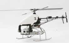
With some exceptions, drone flights in the U.S. have been all about developing and testing surveillance technology.  The North Little Rock Police Department, for instance, wrote that their SR30 helicopter-type drone “can carry day zoom cameras, infrared cameras, or both simultaneously.”  Not to be outdone, the Seattle Police Department’s drone comes with four separate cameras, offering thermal infrared video, low light “dusk-dawn” video, and a 1080p HD video camera attachment. The Miami-Dade Police Department and Texas Department of Public Safety have employed drones capable of both daytime and nighttime video cameras, and according to the Texas Department of Public Safety’s Certificate of Authorization (COA) paperwork, their drone was to be employed in support of "critical law enforcement operations.”
Ogden BlimpHowever, the FAA didn’t just rubber stamp all drone requests. For example, the Ogden Police Department wanted to use its “nocturnal surveillance airship [aka blimp] . . . for law enforcement surveillance of high crime areas of Ogden City.” The FAA disapproved the request, finding Odgen’s proposed use “presents an unacceptable high risk to the National Airspace System (NAS).”
Finding Customers
Several of the requests for drone flights in the U.S. were filed so that manufacturers could show off their aircraft to potential buyers.  Unmanned Systems, Inc., for one, wanted permission to “perform demonstrations and train customer crews” on their Sandstorm drone. (p. 37) Not above a little name-dropping, the company explained that they were looking for approval “for a one-time use market survey event hosted by Montana State Senator Ryan Zinke(p. 41).
Similarly, Telford Aviation—makers of a lighter-than-air (LTA) drone—sought permission to “determine if a suitable market exists for a LTA UAS [Unmanned Aircraft System] aircraft and to demonstrate to prospective customers the advantages associated with a LTA UAS.”  The company noted that “prospective customers, both civilian and government, will have the opportunity to see actual flight characteristics and be afforded the opportunity to attach different payloads to the LTA UAS aircraft for evaluation.”
Teaching Pilots
As more and more drones are allowed in the U.S., the need for pilots should increase as well. That would explain why several of the COA applicants were public entities hoping to train the next generation of drone operators. The City of Herington, Kansas wrote that they want to provide student training for a drone platform, and Eastern Gateway Community College asked for permission to offer training in drone operation, including “the use of and integration of UAS payload systems as a safe and effective tool for law enforcement, emergency responders and other government agencies.” Texas A&M further wanted to examine “mixed human-robot team processes” and “semi-autonomous pilot assistance technologies,” with a focus on emergency response.
Staying Optimistic
Honeywell T-Hawk DroneThe applications frequently discuss contingency procedures, but given that most of the vehicles are lightweight and will be flown (at least at this stage) over unpopulated areas, the danger from falling drones is relatively minimal for most Americans (though not without risk, as Montgomery County, Texas and the U.S. Navy found out recently).  Honeywell International, however, had to use some verbal acrobatics in discussing its MAV drone—a “ducted-fan vehicle,” or what is essentially an engine that lifts itself off the ground. The catch, as Honeywell writes, is that “if the engine is starved, the vehicle will lose thrust and the MAV flight path will become a gravity-dominated ballistic trajectory with an eventual ground impact” (p. 93).  In other words, look out below.
More Reasons to be Optimistic
Since the FAA first started releasing records to EFF, the public has been pushing back on broad and suspicionless use of drones by law enforcement. At the request of reporters,advocacy organizations and local city councils, public agencies have been required to justify their drone purchases and develop clear policies on when and under what conditions they will use drones for surveillance. In light of this public pressure, the Seattle Police Department recently released records in response to a public records request from our friend Glen Milnerand included a copy of its policies for use of unmanned aerial systems (UASs) (p. 3). These policies include some limitations on use and a requirement that the Department log all drone flights—a step in the right direction.
This new information is important, but it’s only a start. With the help of MuckRock, EFF is asking the Internet community to join us in pushing for even more transparency around the use of drones for domestic surveillance.  If you’d like to find out how your local law enforcement agency may be using drones, please visit Muckrock's site to submit your online public records request. 
You can find the records referenced above here (click on "Documents").

Attached Documents