Welcome to RouteScout - a moving collection involving media-centric bits and pieces for Spatial Ground Imagery and Corridor Patrol interests
Showing posts with label smartphone. Show all posts
Friday, May 30, 2014
Toughen-up for Daily Use...
Labels:
Android Hardphone,
Citizen Sensor,
smartphone,
Soldier Sensors
Wednesday, October 9, 2013
Spike the Punch
Spike Kickstarter Project Puts Accurate Laser Measurement Hardware Right On Your Smartphone
TechCrunch by Darrell Etherington 3:01 am
Smartphones have pretty good cameras, but nowhere near good enough to do the kind of high accuracy measurement work that’s required for engineering or remodelling projects. Enter Spike, a new smartphone attachment designed by ikeGPS, a company that specializes in building fit-for-purpose laser hardware for use in surveying and 3D modelling.
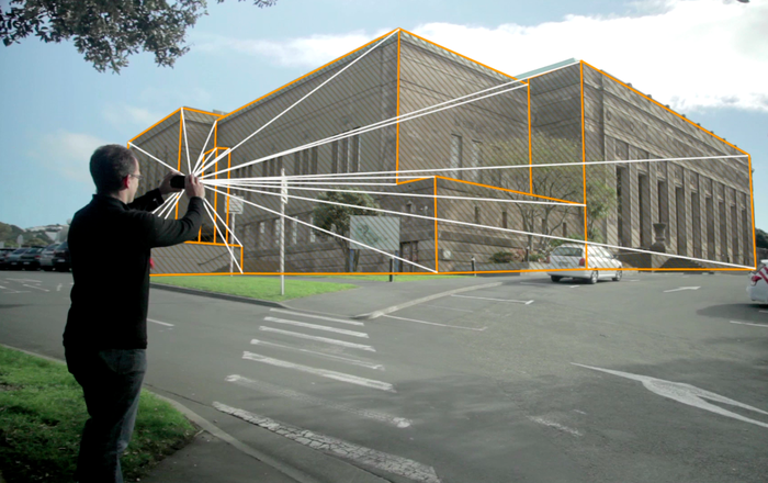
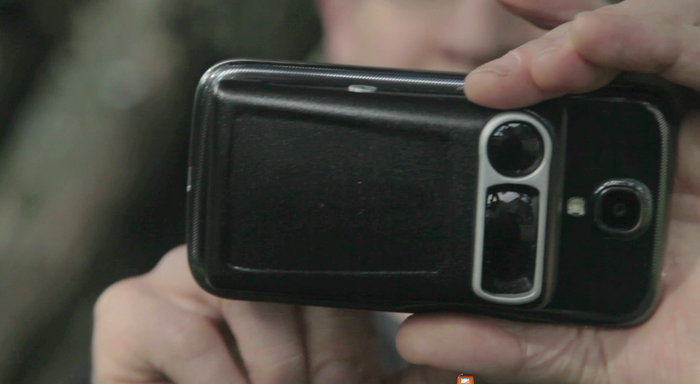
The Spike is version of their solution that attaches to the back of a smartphone and integrates directly with software on those devices to make it possible to measure objects and structures accurately from up to 600 feet away, just by taking a picture with your device. The accessory itself ads a laser range finder, advanced GPS a 3D compass and another digital camera to your smartphone’s existing capabilities, and it’s much more portable than existing solutions (pocketable, even, according to ikeGPS).
The benefits of the Spike and its powers are evident for the existing market ikeGPS already sells to; telecom and utility companies, architects, city planners, builders and more would be better served with a simple portable accessory and the phone they already have in their pocket than by specialized equipment that’s heavy, bulky, requires instruction on proper use and lacks any kind of easy instant data portability like you’ll get from a smartphone app’s “Share” functions.
But ikeGPS is after a new market segment with the Spike, too. It says the device is “built for developers & hackers,” and they suggest augmented reality as a possible consume applications, but are interesting in seeing exactly what the dev community can come up with via its full-featured API. Laser accurate measurements could indeed bring interesting features to location-based apps, though Spike is clearly more interested in letting developers more experienced with that segment of the market figure out the details.
Spike plans to eventually build a case attachment to make it compatible with any phone and case combo, though at launch it’ll be doing this via a CAD model which owners of the device can use to get mounts 3D printed themselves. It’ll work a bit like the Sony QX10 and QX100 smartphone camera lens accessories, it sounds like, and make it possible to use with any iOS or Android device.
The goal of Spike’s founding team, which includes founder and CTO Leon Toorenburg, who built ikeGPS (neĆ© Surveylab) to fit the needs of professionals, is to make this kind of tech widely available. It’s another example of costs associated with tech decreasing quickly, and making it ultimately possible to provide something that once required a professionally trained operator and expensive, specialized hardware usable by anyone with a phone. ikeGPS techhas been used by UN and US Army engineers in disaster recover and emergency response, and now its team wants to make those same capabilities open to app developers. Others like YC company Senic are looking to accomplish similar things, but Spike’s vision is much more sweeping at launch.
The project is just over halfway to its $100,000 funding goal, and $379 scores backers a pre-order unit, which is scheduled to ship in April next year. Building a consumer device is different from building very specialized hardware on what’s likely a made-to-order basis, but at least the team has the know-how and experience to make its tech actually work.
Tuesday, October 8, 2013
Marines to Bring their Own Device HuRah!!
Enterprise IT
Marine Corps mobile device strategy looks to cut costs
- By Nicole Grim
- Jul 26, 2013
Squeezed by budget cuts and seeking to leverage commercial technologies, the U.S. Marine Corps is adopting a new approach to its mobile device strategy as a way to creatively cut costs while getting secure handsets into the hands of more service personnel. In a keynote presentation at the Defense Systems Innovation Forum on July 25, Rob Anderson, chief of the Marine Corps’ vision and strategy division, outlined the strategy that leverages collaboration with commercial partners and other federal agencies.
Anderson said the requirements of the Marine Corps’ mobile strategy focus on security, collaboration and cost effectiveness to deliver a secure mobile device capability. For command and control, this approach will enhance the service’s ability to collect and share data in real time on the battlefield.
Another focus of the Marine strategy is incorporating personal mobile devices into service networks.
Known as bring your own device, or BYOD, the approach allows users to gain limited access to an agency’s secure network and content. The personal device would run two operating systems simultaneously, giving users the best of commercial and defense enterprise services. “This is something that a lot of people in the dotmil [domain] would like to do, but we’re not there yet,” said Anderson. “However, we believe that there is already precedence in personal devices connecting to the defense infrastructure network.”
In a variation on the traditional BYOD approach, Anderson said the Marine Corps aims to allow users to “bring [their] own approved devices,” which are instead procured by the government but paid for by the user, managed by a service provider and supported by leveraging the platforms of other agencies like the Defense Information Systems Agency.
“Just for our BlackBerries today… 55 percent of [our costs] are on maintenance. It’s not on voice and data plans,” Anderson said, adding that there are only two ways to save money: eliminate users or reduce infrastructure requirements.
“Our mobility strategy is based straight up on IT investment opportunities,” he said. “In other words, cost avoidance.”
To reduce the 15,000 current users with government-procured devices, the Marine Corps will draw tighter distinctions between users whose missions are either essential or critical and those whose missions are not. Under the plan, these “privileged” users will supply their own device and data plan. Unlike their non-privileged counterparts, these users' expenses will be partially reimbursed by the Marine Corps.
In another cost cutting move, Anderson said the Marine Corps will rely on commercial providers rather than federal agencies for mobile device management (MDM). Anderson said he has talked extensively with Sprint, Verizon and AT&T to develop an implementation plan that would allow the service to outsource its security policies.
“The DOD commercial device implementation plan [talks] about rolling all the MDMs within the services up to DISA. Well, our intent is to not have a MDM at all, and have a carrier manage that -- based upon the DISA’s security policies.”
Anderson also envisions savings by simply not building platforms already in development. “We will not build a classified environment to support mobility,” he said. “We do not have the money for it.”
Instead, it will rely on DISA initiatives to fill the gap. Similarly, citing a contract DISA awarded in June to Digital Management Inc. for mobile application and device management, Anderson said the service will not create an application store for its users. “Why would we spend money on something that DISA already spends money on?”
In August, the service will distribute a survey to potential users in order to gauge interest in the BYOD program. Anderson said he hopes the incentive to gain secure access with a personal device will be sufficient for users to pay for their own plans. Next, data testing will occur with 20 users to confirm that commercial carriers can provide MDM. If successful, a pilot testing program with 500 users is expected to begin by early 2014, with a system deployed across the entire Marine Corps by next July.
The greatest challenge, Anderson concluded, is proving the business case to commercial carriers. Without carrier agreements in place to supply trusted handheld devices, the Marine Corps will be forced to shift to an alternative mobile security strategy, he warned.
Saturday, August 24, 2013
FLIR gets Smart....phone?
August 19, 2013 5:10 PM
Put away those night-vision goggles.
The idea behind the eye-catching device, CEO Andrew Teich says, is to demonstrate the company's new line of miniature Quark camera cores. But he does not rule out the possibility of turning the prototype into a real consumer gadget and giving consumers the chance to take IR pictures with their phones. That depends on whether FLIR can get high tech and low prices to meet halfway.
The company began rolling out Quark in the spring of 2011 as a follow-on to its Tau infrared series, which has been used on small drones such as the Army's RQ-11 Raven. The new Quark core measures just three-quarters of an inch thick and comes in a range of resolutions, the most powerful being 640 x 480, or 0.3 megapixels.
Of course, none of the Quark camera cores will produce glossy, nighttime portraits you'd frame and hang in your living room. Still, Teich says, a 0.3-megapixel core with a 9-mm lens, like the one fitted into the camera-phone sled shown at AUVSI, "can spot a person at about 300 yards."
Read more: Infrared Cameras Now Small Enough to Be in Your Phone - Popular Mechanics
Follow us: @PopMech on Twitter | popularmechanics on Facebook
Visit us at PopularMechanics.com
Thursday, July 25, 2013
Galaxy Camera Code - Smart Camera and Immersion time to get cracking
Samsung releases Galaxy Camera code, Android experts start
The Samsung Galaxy Camera runs Android 4.1 but does not come with the ability to make calls.
Android experts are looking at the Galaxy Camera’s code to find a way to hack the newly released camera into a fully functioning phone.
Samsung officially released the open source kernel files for the Galaxy Camera to developers a few days before their U.S. launch. The camera, listed on Samsung's source code site as mobile phone “EK-GC100,”runs Android 4.1 (Jelly Bean).
The Galaxy Camera does not place phone calls even though it does blur the lines between camera and smartphone with 3G/4G and Wi-Fi connectivity, a speaker and microphone and the ability to run apps like Skype.
Another Android 4.3 Change: Photo Spheres Look A Lot Better Now
Android News, Reviews, Applications, Games, Phones, Devices, Tips, Hacks, Videos, Podcasts - Android Policeby David Ruddock 1:50 pm
Google Maps product manager Evan Rapoport revealed another Android 4.3 change on Google+ this morning - better photo spheres. Photo spheres were introduced in Android 4.2, and I truly believe they're one of the biggest things to happen to personal photography in years. They're limited to Nexus devices for the time being - and viewing outside of Maps / Google+ is still hard - but it's encouraging to see that Google is still going strong developing the feature.
There are two changes to photo spheres in Android 4.3, but they're big ones. First, alignment and stitching are "much better" - arguably two of the biggest problems with photo spheres. Second, exposure compensation across individual frames is now better, meaning your photos won't look weirdly washed out or dark in certain regions as you pan around.
Your photo spheres are going to look prettier. And based on the sphere Evan uploaded to showcase the changes, I believe it - there is still some visible stitching and a couple of alignment anomalies, but the exposure is remarkably consistent compared to a lot of the older spheres I've seen, as is the overall composition. Just one more thing to look forward to (for Nexus users, at least) in the latest version of Android.
Done With This Post? You Might Also Like These:
Google Play Services Receives Two Awesome New APIs: Vector-Based Google Maps, And Photo Sphere Viewer
Download The Android 4.2 Camera/Gallery App With New UI, Editing, Photo Sphere [Update: Now With Working Sphere Viewer]
[New Game] Cubes Vs. Spheres Brings A Grand Geometric Struggle To Your Android Device
Here Are The New Android 4.2 And Google Now Features - Including The Amazing Photo Sphere
Google Play Services Receives Two Awesome New APIs: Vector-Based Google Maps, And Photo Sphere Viewer
Download The Android 4.2 Camera/Gallery App With New UI, Editing, Photo Sphere [Update: Now With Working Sphere Viewer]
[New Game] Cubes Vs. Spheres Brings A Grand Geometric Struggle To Your Android Device
Here Are The New Android 4.2 And Google Now Features - Including The Amazing Photo Sphere
Sunday, July 14, 2013
Bugeye for Smart Phone...
Pelican Imaging's 16-lens array camera coming to smartphones next year
from Engadget by Sharif Sakr
After yesterday's news about Nokia investing in Pelican Imaging's plenoptic camera system, it was hard not to feel impatient about exactly when this technology might arrive in real, commercially available smartphones. Well, we have an update on that front: although the company's CEO, Chris Pickett, wouldn't tell us which OEM(s) he's been talking to, he did say that his product is currently being trialed by device manufacturers and is scheduled to be part of at least one new smartphone launching in 2014. Now, this next bit is pure speculation on our part, but given that carrier testing alone can take six months, and we're already nearly halfway through 2013, this strongly implies that a hardware deal has already been inked -- which means next year could potentially bring the biggest news in smartphone cameras since the eternally underappreciated Nokia PureView 808. Speaking of which, Pelican Imaging also has some intriguing things to say about what could happen if its array camera was paired with Nokia's PureView technology -- read on for more.
Camera inspired by insect eyes can see 180 degrees, has almost infinite depth of field
from Engadget by Terrence O'Brien
Technologists have been drawing inspiration from the insect world for a long time. And folks working on robotics really seem to love their creepy-crawlies and buzzing arthropods. Researchers at the University of Illinois are looking to our eight-legged planet mates, not for mobility lessons, but as a reference for a new camera design. The system mimics the vision of bees and mantises by combining multiple lenses on a half hemisphere to provide a 180-degree view with a nearly infinite depth of field. The optics themselves are described as "soft, rubbery" and each individual microlens is paired with its own photodiode. The work gets us a heck of a lot closer to the dream of a digital fly eye than previous efforts, though we're likely still quite a while from seeing applications outside of the lab. DARPA funding suggests the artificial compound eyes may have a future in surveillance, though the researchers also see uses for it in medicine.
Thursday, July 4, 2013
Bluetooth Aura.. Leiger/geiger counter on the foot
Chernobyl and Back
from SparkFun Electronics - Recent News Posts by SparkFun Electronics
https://www.sparkfun.com/news/1146
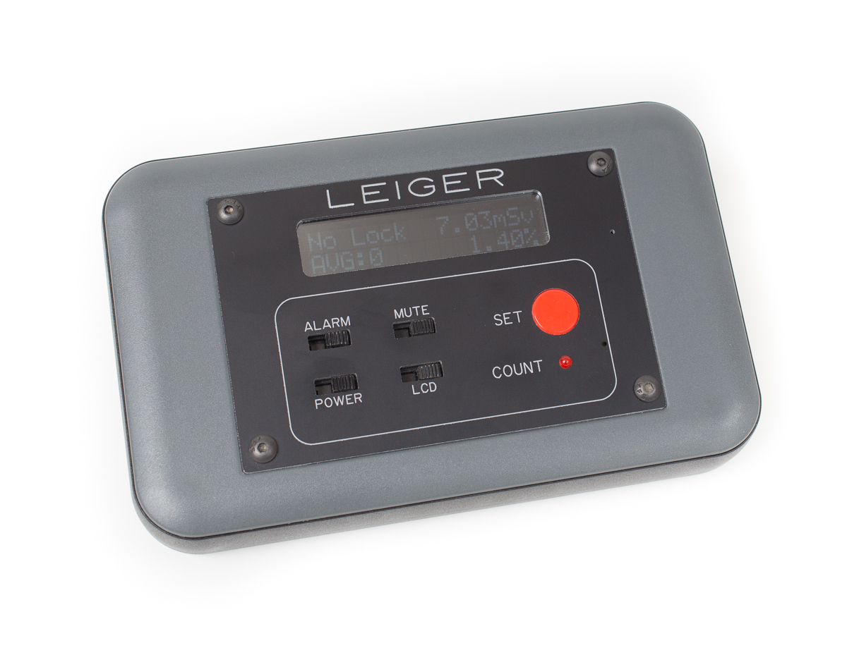
A couple months ago, I left for Chernobyl to do some photography and take some readings with my DIY geiger counter/logger. If you missed the original post about the trip, you can check it out here. I’m back now, and not only do I have some pictures, I’ve got some stories and of course some data. I’d like to say the Leiger worked perfectly, but that would be a lie. I ended up getting good data, but there were also some problems.
As I talked about in the video a couple months ago, I had a simple message that showed up on the screen to let me know if there was a GPS lock or not. Unfortunately, it always showed ‘no lock’ even if there was valid GPS information. I still haven’t fully gone through the code to figure out what happened, but I suspect it’s the way I was determining if the GPS sentences were valid or not. At first, I thought the GPS module had decided to kick the bucket. Thankfully, Dave brought his laptop and we were able to verify that the data was good and there was a GPS lock. But that wasn’t the only problem I encountered.
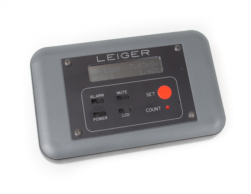
By my estimates (and real-world testing), I determined the Leiger could last around 26 hours on a single charge. However, about 6 hours into our first flight, I went to check on the Leiger, and it was dead! There’s an old saying, ‘if it ain’t broke, don’t fix it’. I should have remembered that. The day before the trip, I noticed there was a VERY faint sound coming from the buzzer. It was most likely some feedback from the high voltage side of the board. It was only audible in a very quiet room, with the enclosure off. But, it bothered me enough that I decided I’d try and ‘fix’ it. I ended up grounding the other side of the slide switch, which made it silent, unless it was enabled. So now the buzzer could be truly silenced.
At the time, I didn’t realize that when the buzzer was turned ‘off’, it was actually just shorting out the power supply. So that 26 hour run-time went down to just a few hours, and also made the whole unit get pretty warm inside. Thankfully I figured it out while I should have been sleeping on the plane. As soon as we landed in Kiev, I used my trustyLeatherman to open the case, dissemble the PCB, and cut the ground wire. It was still telling me it didn’t have a GPS lock when it actually did, but at least the power supply was good and it was logging data. It seems no matter how much you test something, or plan your design, there’s always going to be a problem. Thankfully, mine were relatively minor. I did end up getting some good numbers from the trip. Before we get into the actual data, I’d like to explain a bit more about the hardware inside the Leiger.
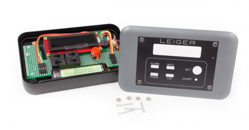
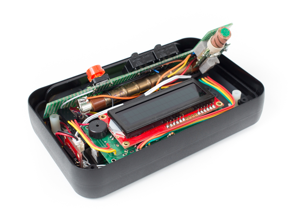
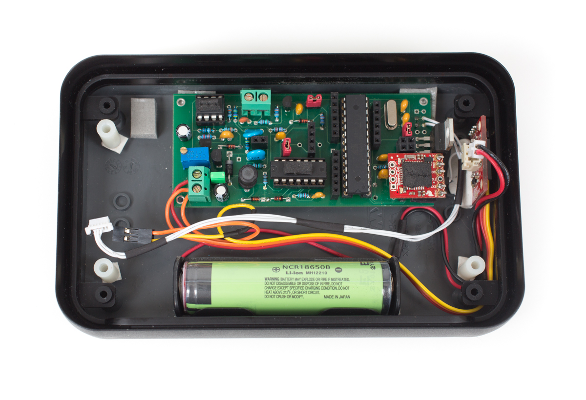
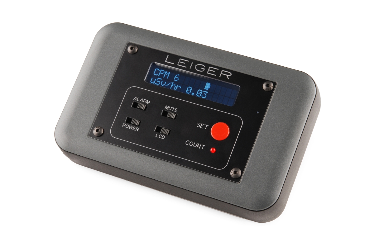
The main portion of the Leiger is based on the fantastic DIYGeigerCounter project. I bought it as a kit and made a few tweaks and adjustments. I wanted a simple interface for turning on and off the LED, buzzer, and screen. So, I moved a lot of the LEDs and buttons to a separate PCB. The PCB started as a standard protoboard, but I cut and hand-filed it down to the size I needed. I added some switches, a button, LED, and various connectors and mounting holes. I also needed a way to mount the GPS (a D2523T), as well as the geiger tube (SBM-20) itself. The case was from OKW Enclosures and faceplate was designed in SolidWorks and machined by Front Panel Express. As you can see, not much space is wasted here. I wanted it to be as small as possible.
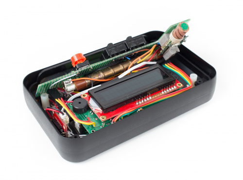
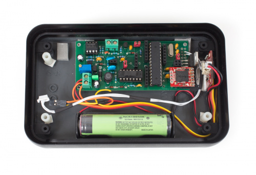
The control PCB as well as the LCD ‘shield’ sit on top of everything else, and cover the rest of the electronics. Once they are removed, you can see the actual Geiger counter board, the ATmega328, an OpenLog, and a PowerCell. The PowerCell worked wonders for this project and provides 5V to everything (except for the GPS, which has its own 3.3v voltage regulator), and charges the 18650 battery. Programming and testing was a bit tricky as the OpenLog sat on the FTDI header and needed to be removed for programming. Since most of the unit needed to be disassembled to get down there, I estimate I’ve completely disassembled the Leiger a few dozen times. If you look closely, you can see a lot of grey foam tape, which worked well for keeping everything in place, as well as added a bit of shock-proofing for travel.
Here is the code for the Leiger. I’m not a great programmer, so excuse the mess. It mostly works though. Ultimately, it just used an interrupt to count particles, and then displayed it on the screen in various fashions. It also stored these values at regular intervals (along with the GPS data) on an microSD, courtesy of the OpenLog. For keeping track of dosage (overall radiation exposure), I wrote this value to the EEPROM. I chose to write it to the EEPROM instead of the microSD because the RX (receive) was already being used by the GPS, so there was no elegant way to read in the dosage information when the unit was turned on. I didn’t want to rely on the softserial library (which is awesome) because I didn’t want to mess with the interrupts, which proved to be a good decision). In the end, all the information I wanted got logged. So, how radioactive was Chernobyl?
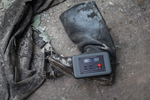
There’s not a really easy answer for this. Generally speaking, it’s not very radioactive. The vast majority of the zone has been decontaminated and is roughly the same level of radiation as the rest of the world. However, in a few instances, Chernobyl lives up to the hype. Normal background radiation (as measured by the Leiger), is around 20-30 CPM (counts per minute, or about 0.14 uSv/hour). In the picture above, you can see a reading of over 622 uSv/hour, or about 4500 times background. Also, if you’re doing the math, 10922 CPM doesn’t actually convert out to 622 uSv/hour. At first I thought it was an error. Actually, I didn’t anticipate measuring over 100k CPM, so the screen just isn’t formatted to display numbers that high. But as you can see in the data (posted below), it did peak at over 100k CPM (keep in mind that’s nearly 1500 counts every second).
What you’re seeing in the picture is a boot worn by one of the firefighters that responded immediately after the explosion. After 25+ years, it’s still extremely radioactive (I didn’t stay long). It was sitting in a hallway in the basement of the hospital. It amazes me that after all this time, artifacts like this still exist. We even saw a claw that was used to remove radioactive material from the roof of reactor 4. Overall though, with the exception of a few radioactive places and objects, the radiation is well controlled. So how much radiation did I end up getting?

After looking over the data, I came up with a good number. I took the total dosage (as recorded from the Leiger) over the course of the full 4 days I was in the exclusion zone. For all hours not accounted for with the Leiger (sleeping, when it was charging, etc), I took the background averages and filled in the missing gaps in the logs. Based on my readings for background levels here at home, and the total dosage I got from Chernobyl, I concluded that my 4 days in the exclusion zone was equal to just under 3 years of normal background radiation. It’s a lot in a short period of time, but it’s still well below the yearly limit for radiation workers, and just a fraction of the levels known to cause health problems.
Originally, I had planned to do a map of the radiation for the zone, but after getting the data back, I saw that the huge variances made graphing or mapping anything problematic. Because the hot spots were generally several thousand times higher than the surrounding area (and often-times inside a building), setting a scale was nearly impossible. I do encourage you to download the data and sort by the uSv rate. You will find some interesting places. See if you can find the cooling towers, Jupiter factory, hospital, cemetery (the only place in Pryp'yat that wasn’t decontaminated) and of course outside reactor 4.

For those of you that skipped down to the bottom, or missed the links in the text, here is the data, the Leiger code, and my pictures from the trip. Thanks for reading (or at least scrolling this far down). It was an amazing trip, and I’m very glad I went. For a photographer, just having access to these amazing locations was an experience of a lifetime. This was all a lot to cover and I’m sure I’ve left out some important details, so feel free to ask questions in the comments. Thanks again for reading.
A couple months ago, I left for Chernobyl to do some photography and take some readings with my DIY geiger counter/logger. If you missed the original post about the trip, you can check it out here. I’m back now, and not only do I have some pictures, I’ve got some stories and of course some data. I’d like to say the Leiger worked perfectly, but that would be a lie. I ended up getting good data, but there were also some problems.
As I talked about in the video a couple months ago, I had a simple message that showed up on the screen to let me know if there was a GPS lock or not. Unfortunately, it always showed ‘no lock’ even if there was valid GPS information. I still haven’t fully gone through the code to figure out what happened, but I suspect it’s the way I was determining if the GPS sentences were valid or not. At first, I thought the GPS module had decided to kick the bucket. Thankfully, Dave brought his laptop and we were able to verify that the data was good and there was a GPS lock. But that wasn’t the only problem I encountered.

By my estimates (and real-world testing), I determined the Leiger could last around 26 hours on a single charge. However, about 6 hours into our first flight, I went to check on the Leiger, and it was dead! There’s an old saying, ‘if it ain’t broke, don’t fix it’. I should have remembered that. The day before the trip, I noticed there was a VERY faint sound coming from the buzzer. It was most likely some feedback from the high voltage side of the board. It was only audible in a very quiet room, with the enclosure off. But, it bothered me enough that I decided I’d try and ‘fix’ it. I ended up grounding the other side of the slide switch, which made it silent, unless it was enabled. So now the buzzer could be truly silenced.
At the time, I didn’t realize that when the buzzer was turned ‘off’, it was actually just shorting out the power supply. So that 26 hour run-time went down to just a few hours, and also made the whole unit get pretty warm inside. Thankfully I figured it out while I should have been sleeping on the plane. As soon as we landed in Kiev, I used my trustyLeatherman to open the case, dissemble the PCB, and cut the ground wire. It was still telling me it didn’t have a GPS lock when it actually did, but at least the power supply was good and it was logging data. It seems no matter how much you test something, or plan your design, there’s always going to be a problem. Thankfully, mine were relatively minor. I did end up getting some good numbers from the trip. Before we get into the actual data, I’d like to explain a bit more about the hardware inside the Leiger.

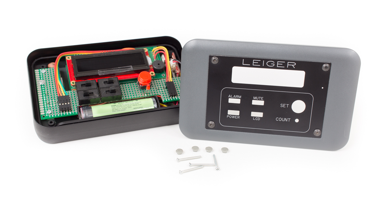
The main portion of the Leiger is based on the fantastic DIYGeigerCounter project. I bought it as a kit and made a few tweaks and adjustments. I wanted a simple interface for turning on and off the LED, buzzer, and screen. So, I moved a lot of the LEDs and buttons to a separate PCB. The PCB started as a standard protoboard, but I cut and hand-filed it down to the size I needed. I added some switches, a button, LED, and various connectors and mounting holes. I also needed a way to mount the GPS (a D2523T), as well as the geiger tube (SBM-20) itself. The case was from OKW Enclosures and faceplate was designed in SolidWorks and machined by Front Panel Express. As you can see, not much space is wasted here. I wanted it to be as small as possible.

The control PCB as well as the LCD ‘shield’ sit on top of everything else, and cover the rest of the electronics. Once they are removed, you can see the actual Geiger counter board, the ATmega328, an OpenLog, and a PowerCell. The PowerCell worked wonders for this project and provides 5V to everything (except for the GPS, which has its own 3.3v voltage regulator), and charges the 18650 battery. Programming and testing was a bit tricky as the OpenLog sat on the FTDI header and needed to be removed for programming. Since most of the unit needed to be disassembled to get down there, I estimate I’ve completely disassembled the Leiger a few dozen times. If you look closely, you can see a lot of grey foam tape, which worked well for keeping everything in place, as well as added a bit of shock-proofing for travel.

Here is the code for the Leiger. I’m not a great programmer, so excuse the mess. It mostly works though. Ultimately, it just used an interrupt to count particles, and then displayed it on the screen in various fashions. It also stored these values at regular intervals (along with the GPS data) on an microSD, courtesy of the OpenLog. For keeping track of dosage (overall radiation exposure), I wrote this value to the EEPROM. I chose to write it to the EEPROM instead of the microSD because the RX (receive) was already being used by the GPS, so there was no elegant way to read in the dosage information when the unit was turned on. I didn’t want to rely on the softserial library (which is awesome) because I didn’t want to mess with the interrupts, which proved to be a good decision). In the end, all the information I wanted got logged. So, how radioactive was Chernobyl?

There’s not a really easy answer for this. Generally speaking, it’s not very radioactive. The vast majority of the zone has been decontaminated and is roughly the same level of radiation as the rest of the world. However, in a few instances, Chernobyl lives up to the hype. Normal background radiation (as measured by the Leiger), is around 20-30 CPM (counts per minute, or about 0.14 uSv/hour). In the picture above, you can see a reading of over 622 uSv/hour, or about 4500 times background. Also, if you’re doing the math, 10922 CPM doesn’t actually convert out to 622 uSv/hour. At first I thought it was an error. Actually, I didn’t anticipate measuring over 100k CPM, so the screen just isn’t formatted to display numbers that high. But as you can see in the data (posted below), it did peak at over 100k CPM (keep in mind that’s nearly 1500 counts every second).
What you’re seeing in the picture is a boot worn by one of the firefighters that responded immediately after the explosion. After 25+ years, it’s still extremely radioactive (I didn’t stay long). It was sitting in a hallway in the basement of the hospital. It amazes me that after all this time, artifacts like this still exist. We even saw a claw that was used to remove radioactive material from the roof of reactor 4. Overall though, with the exception of a few radioactive places and objects, the radiation is well controlled. So how much radiation did I end up getting?

After looking over the data, I came up with a good number. I took the total dosage (as recorded from the Leiger) over the course of the full 4 days I was in the exclusion zone. For all hours not accounted for with the Leiger (sleeping, when it was charging, etc), I took the background averages and filled in the missing gaps in the logs. Based on my readings for background levels here at home, and the total dosage I got from Chernobyl, I concluded that my 4 days in the exclusion zone was equal to just under 3 years of normal background radiation. It’s a lot in a short period of time, but it’s still well below the yearly limit for radiation workers, and just a fraction of the levels known to cause health problems.

Originally, I had planned to do a map of the radiation for the zone, but after getting the data back, I saw that the huge variances made graphing or mapping anything problematic. Because the hot spots were generally several thousand times higher than the surrounding area (and often-times inside a building), setting a scale was nearly impossible. I do encourage you to download the data and sort by the uSv rate. You will find some interesting places. See if you can find the cooling towers, Jupiter factory, hospital, cemetery (the only place in Pryp'yat that wasn’t decontaminated) and of course outside reactor 4.

For those of you that skipped down to the bottom, or missed the links in the text, here is the data, the Leiger code, and my pictures from the trip. Thanks for reading (or at least scrolling this far down). It was an amazing trip, and I’m very glad I went. For a photographer, just having access to these amazing locations was an experience of a lifetime. This was all a lot to cover and I’m sure I’ve left out some important details, so feel free to ask questions in the comments. Thanks again for reading.
Labels:
Blue2CAN,
Citizen Sensor,
smartphone,
soldier sensor
Tuesday, February 26, 2013
Pee Dispsticks
And for Their Next Trick, Smartphones Will Analyze Your Urine
from All Things Digital by Liz Gannes
Testing urine can reveal diseases, pregnancy, drug usage, dehydration, diet problems and more. But urine tests are not terrifically accessible — companies like Siemens make proprietary urine dipsticks that are read only by their expensive proprietary machines.
Myshkin Ingawale of Biosense Technologies has developed an iPhone app to make that process much more accessible. The aim of uChek is to make analyzing pee so simple that people around the world can do it at home to test and monitor their own health.
As Ingawale put it, the conclusion was inevitable: “Cellphones, everybody has them. And everybody pees. There has to be something interesting going on here.”
He quipped in a well-received talk at the TED conference on Monday, “The future might not be in your hand; it might well be down the toilet.”
The uChek app works with any urine-test dipstick, with the familiar set of colored boxes that change to indicate levels of things like ketones and pH in the pee.
To use the app, you dip the stick in the pee and put it down next to a washable color mat, then take a picture of the two at certain time intervals. The point of the mat is to provide a reference color palette that can be compared to the stick in any light. Then the app locally analyzes what it sees, and displays the levels and the trends.
After Ingawale demoed this process on stage with a cup of pee, nobody was quite sure whether to shake his hand.
Biosense Technologies employs 10 people in Mumbai, and raised $500,000 from Insitor Fund and GSF India, Ingawale told me in an interview offstage.
He said he expects to launch uChek on March 25. The app will likely cost $0.99, and the mat will cost $20. An Android version is the next priority.
UChek is actually Biosense’s second product, and this was Ingawale’s second TED talk. Last year, he debuted an anemia detector that doesn’t require a needle, called ToucHB. That device has been redesigned over the past year, and is now shipping in limited quantities in India, he said.
Myshkin Ingawale of Biosense Technologies has developed an iPhone app to make that process much more accessible. The aim of uChek is to make analyzing pee so simple that people around the world can do it at home to test and monitor their own health.
As Ingawale put it, the conclusion was inevitable: “Cellphones, everybody has them. And everybody pees. There has to be something interesting going on here.”
He quipped in a well-received talk at the TED conference on Monday, “The future might not be in your hand; it might well be down the toilet.”
The uChek app works with any urine-test dipstick, with the familiar set of colored boxes that change to indicate levels of things like ketones and pH in the pee.
To use the app, you dip the stick in the pee and put it down next to a washable color mat, then take a picture of the two at certain time intervals. The point of the mat is to provide a reference color palette that can be compared to the stick in any light. Then the app locally analyzes what it sees, and displays the levels and the trends.
After Ingawale demoed this process on stage with a cup of pee, nobody was quite sure whether to shake his hand.
Biosense Technologies employs 10 people in Mumbai, and raised $500,000 from Insitor Fund and GSF India, Ingawale told me in an interview offstage.
He said he expects to launch uChek on March 25. The app will likely cost $0.99, and the mat will cost $20. An Android version is the next priority.
UChek is actually Biosense’s second product, and this was Ingawale’s second TED talk. Last year, he debuted an anemia detector that doesn’t require a needle, called ToucHB. That device has been redesigned over the past year, and is now shipping in limited quantities in India, he said.
Saturday, January 12, 2013
Saturday, January 5, 2013
Smartphone IR
Smartphone Thermal Imaging Attachment Becomes a Reality
- DL Cade · Dec 29, 2012
As with the original version, the IR-Blue uses a 64 zone non-contact InfraRed sensor array to sense the temperature of whatever you’re pointing your phone at. Unlike the original, this version did away with the dock connection in favor of Bluetooth.
Both the iPhone and Android apps will be a free download, and then you’ve got a few options. You can pledge $12 and get a plain, printed IR-Blue circuit board — hardcore DIYers only. You can pledge $145 and get all of the parts you’ll need to build your own — beginner and intermediate DIYers who own a soldering iron are welcome. Or you can pledge $175 and get a fully put together and tested IR-Blue,
Here’s what the system looks like for iPhone and Android:
There’s no need to worry about the possibility that the IR-Blue won’t come to fruition — Rawson’s campaign has already hit $105K, more than quintupling his original $20K goal — but if he hits $150K in the next 15 days, the IR-Blue will come equipped with dual-mode Bluetooth 2.0 and 4.0 built right in.
To add your pledge to the pot or turn your smartphone into a thermal camera for cheap (the suggested retail price is $195), head over to Kickstarter and check out the IR-Blue for yourself.
Wednesday, December 5, 2012
SmartPhone in War or ...?
The Cell Phone in War
A striking photo highlights a new facet of modern warfare.
These are five government troops in the Democratic Republic of Congo, three of whom, according to Reuters' caption, are recording video with their phones. They are in the town of Sake, near the town of Goma, which rebels captured last month.
I don't know what to say about this photograph aside from suggesting that an enterprising PhD student write a dissertation on "Cell Phones in War." How are fighting, killing, and controlling territory different when you can call your brother after battle, post a photo of your squadron on the march to Facebook, or play Angry Birds between skirmishes?
Philip Bump reminded me of this chilling CJ Chivers post from a few months ago in Syria. A soldier sits with a high-caliber machine gun, one hand on the trigger, the other on his phone. Chivers' description:
Update: here's one monograph that touches on some of the military strategy concerns of ubiquitous cell usage, "YOUTUBE WAR: FIGHTING IN A WORLD OF CAMERAS IN EVERY CELL PHONE AND PHOTOSHOP ON EVERY COMPUTER."
I don't know what to say about this photograph aside from suggesting that an enterprising PhD student write a dissertation on "Cell Phones in War." How are fighting, killing, and controlling territory different when you can call your brother after battle, post a photo of your squadron on the march to Facebook, or play Angry Birds between skirmishes?
Philip Bump reminded me of this chilling CJ Chivers post from a few months ago in Syria. A soldier sits with a high-caliber machine gun, one hand on the trigger, the other on his phone. Chivers' description:
Machine gun in right hand. Cell phone in left. On duty on the gun-truck's machine gun, at 80 miles an hour into Aleppo, checking messages along the way.
Even as the war in Syria rages, large areas of the countryside have cellular phone coverage, and the fighters are constantly checking their phones. When they stop, many of them immediately look for ways to recharge their phone batteries. And, often as they move and enter an area with a strong signal, they commence texting back and forth.
Update: here's one monograph that touches on some of the military strategy concerns of ubiquitous cell usage, "YOUTUBE WAR: FIGHTING IN A WORLD OF CAMERAS IN EVERY CELL PHONE AND PHOTOSHOP ON EVERY COMPUTER."
Monday, November 26, 2012
SONY Takes #3 Position in Smartphones
Is Sony Gaining Momentum in Smartphones?
By Juro Osawa
While Japan’s ailing consumer-electronics sector struggles to regain momentum, it turns out that Sony Corp. actually climbed to the No. 3 position in the global smartphone market in the third quarter. Sony, which was the No. 6 player in the same quarter a year earlier, came only behind Samsung Electronics Co. and Apple Inc., according to the latest data from research firm IDC.
SonySony’s Xperia smartphone
Does this signal a comeback for Sony, the brand once synonymous with the coolest gadgets?
Probably not.
Sony’s rise to the third place is mostly because of huge market share losses at Nokia Corp., HTC Corp. and Research In Motion Ltd., the maker of BlackBerry handsets.
In the third quarter, Sony held a 4.8% share of the world’s smartphone market by shipments, down slightly from 5.0% a year earlier, according to the IDC data. Meanwhile, Nokia’s market share for the quarter tumbled to 3.4% from 13.6% a year earlier, while HTC’s share dropped to 4.7% from 10.3%. RIM’s share fell to 4.2% from 9.6%.
Last month, IDC released its preliminary smartphone market share data for the third quarter, but Sony wasn’t among the top five, because the Japanese company’s shipment data wasn’t yet available at the time, according to IDC.
The updated data for the third quarter also showed that Samsung, the market leader, increased its share to 31.3% from 22.7% a year earlier, while Apple’s share rose to 14.6% from 13.8%. Samsung and Apple together control nearly half of the market, while none of the other players holds more than 5%.
Moreover, Apple and Samsung are the only ones enjoying strong profits from their handsets, because the iPhone and Samsung’s flagship Galaxy models dominate the high-end segment — the only lucrative part of the entire smartphone market.
Whether Sony can turn around its mobile business likely depends on whether it can grab a larger chunk of the high-end market, where overall growth is not as robust as the low-end segment. To do that, Sony would have to steal some customers away from Apple and Samsung.
Sony’s mobile products and communications division, which includes the mobile handset business, posted an operating loss of Y23,1 billion ($280 million) in the fiscal second quarter through September.
A spokeswoman for Sony’s mobile unit acknowledged Friday that the company’s rise in ranking is due in part to sequential declines at other vendors.
She said Sony is trying to grow in the high-end smartphone market by working closely with the company’s movie business, among others, to promote new handsets.
“The smartphone market is increasingly bifurcating into premium (above $450) and low-end (below $200),” Sanford Bernstein analyst Mark Newman wrote in a report this week. “All the industry profits go to the premium segment and most of the growth is in the low-end, with the mid-end unprofitable and relatively shrinking.”
The market share ranking in terms of shipment volume may change over the next year, given the increase of low-end smartphones in China, as the country is set to become the world’s largest smartphone market this year. Chinese personal-computer and handset maker Lenovo Group Ltd., for example, saw its global market share increase to 3.7% in the third quarter from 0.37% a year earlier, thanks to robust sales in the domestic market.
Even so, there’s little money to be made in the low-end segment, because margins are very thin and a sales growth doesn’t translate into a lot of profit.
Does this signal a comeback for Sony, the brand once synonymous with the coolest gadgets?
Probably not.
Sony’s rise to the third place is mostly because of huge market share losses at Nokia Corp., HTC Corp. and Research In Motion Ltd., the maker of BlackBerry handsets.
In the third quarter, Sony held a 4.8% share of the world’s smartphone market by shipments, down slightly from 5.0% a year earlier, according to the IDC data. Meanwhile, Nokia’s market share for the quarter tumbled to 3.4% from 13.6% a year earlier, while HTC’s share dropped to 4.7% from 10.3%. RIM’s share fell to 4.2% from 9.6%.
Last month, IDC released its preliminary smartphone market share data for the third quarter, but Sony wasn’t among the top five, because the Japanese company’s shipment data wasn’t yet available at the time, according to IDC.
The updated data for the third quarter also showed that Samsung, the market leader, increased its share to 31.3% from 22.7% a year earlier, while Apple’s share rose to 14.6% from 13.8%. Samsung and Apple together control nearly half of the market, while none of the other players holds more than 5%.
Moreover, Apple and Samsung are the only ones enjoying strong profits from their handsets, because the iPhone and Samsung’s flagship Galaxy models dominate the high-end segment — the only lucrative part of the entire smartphone market.
Whether Sony can turn around its mobile business likely depends on whether it can grab a larger chunk of the high-end market, where overall growth is not as robust as the low-end segment. To do that, Sony would have to steal some customers away from Apple and Samsung.
Sony’s mobile products and communications division, which includes the mobile handset business, posted an operating loss of Y23,1 billion ($280 million) in the fiscal second quarter through September.
A spokeswoman for Sony’s mobile unit acknowledged Friday that the company’s rise in ranking is due in part to sequential declines at other vendors.
She said Sony is trying to grow in the high-end smartphone market by working closely with the company’s movie business, among others, to promote new handsets.
“The smartphone market is increasingly bifurcating into premium (above $450) and low-end (below $200),” Sanford Bernstein analyst Mark Newman wrote in a report this week. “All the industry profits go to the premium segment and most of the growth is in the low-end, with the mid-end unprofitable and relatively shrinking.”
The market share ranking in terms of shipment volume may change over the next year, given the increase of low-end smartphones in China, as the country is set to become the world’s largest smartphone market this year. Chinese personal-computer and handset maker Lenovo Group Ltd., for example, saw its global market share increase to 3.7% in the third quarter from 0.37% a year earlier, thanks to robust sales in the domestic market.
Even so, there’s little money to be made in the low-end segment, because margins are very thin and a sales growth doesn’t translate into a lot of profit.
Labels:
smartphone,
Smartphone Statistics,
sony smartphone
Tuesday, September 4, 2012
Pocket Thermal Imaging... AR-FLIR by Hopeless?
This add on device is still a bit in the AR domain but apparently it does work... looks to be a $150 feature add but apparently will provide an open-source code solution? Seems pretty darned cool to me. Rob Hopeless is the wizzard -
Wednesday, July 25, 2012
Non-camera Smartphone...
Asia. Increase in demand for non-camera smartphones in security-related sectors
from picturephoning.com by emily
According to AsiaOne, Smartphone manufacturers they are seeing an increase in demand for smartphones without photo-taking capabilities.
No-frills feature phones are no longer the only option for those who work in areas where camera phones are not allowed.
These days, people with jobs in security-related sectors can still enjoy the connectedness and convenience offered by a smartphone, thanks to models that come without a camera.
Smartphone manufacturers said they are seeing an increase in demand for smartphones without photo-taking capabilities.
Seven mobile-phone shops in Toa Payoh, Singapore, said they have seen an increase in inquiries about such phones. However, the shops declined to provide sales figures.
Chinese smartphone maker Huawei sees opportunities in the non-camera smartphone market, a company spokesman said, citing the firm's market research .Huawei has two such models: the Sonic and Honor.
Thursday, June 28, 2012
Cell-phone Signal Boosters
FCC proposes new requirements for cell-signal boosters
Tuesday, May 29, 2012
Smartphone tracks Radiation Exposure
Mobile phone operator Softbank Corp said on Tuesday it would soon begin selling smartphones with radiation detectors, tapping into concerns that atomic hotspots remain along Japan's eastern coast more than a year after the Fukushima crisis.
Parts of northeastern Japan are still off-limits due to high radiation levels after the Fukushima nuclear plant was devastated by a huge earthquake and tsunami, triggering meltdowns and spewing radiation.
Anti-nuclear sentiment is high, with advocacy groups in Tokyo and other cities calling for radiation monitoring at schools and other public facilities.
"The threat from the nuclear accident cannot be seen by the human eye and continues to be a concern for many people, especially for mothers with small children," said Softbank founder and president, Masayoshi Son, standing in front of an aerial photo of the crippled plant.
The smartphone in the company's "Pantone" series will come in eight bright colors and include customized IC chips made by Sharp Corp that measure radiation levels in microsieverts per hour.
The phone, which goes on sale this summer, can also keep track of each location a user tests for radiation levels.
Son, who emerged as an outspoken critic of nuclear power and advocate of renewable energy sources after last year's quake, told vendors and reporters that the smartphone was more portable and user-friendly than conventional Geiger counters.
Softbank, Japan's No. 3 mobile phone operator, has not set a price on the new smartphone yet, but Son told reporters after the event that it would be in an affordable price range.
Tuesday, April 3, 2012
Red Hen Blue2CAN with Android App
| Geotag with the New Red Hen Android App by Roxanne Laverty on Apr 2, 2012 | ||||
Add the word Geo to the beginning of a word and suddenly it seems to take on a whole new meaning. Geotagging is one such word, simply a photo that is tagged with a latitude and longitude coordinate.
Many handheld GPS units now come with an imbedded camera, to capture the still image and save the location all on the same jpg file. Alternatives to purchasing a dedicated handheld is to use your smartphone and one of the available apps to combine the pictures and their geographical location. Blue 2CAN users who are interested in geotagging can download the MediaMapper Mobile (MMM) app from Red Hen Systems, which will also work with Google Earth. The app essentially changes an Android phone into a portable GPS, capturing track log information in both NMEA and GPX formats. NMEA is the standard GPS language, while GPX is Garmin's specific data format. Other devices that use the Blue 2CAN technology include GPS-enabled Nikon cameras and LTI True Pulse Laser Rangefinders. Users can coordinate up to six devices with MMM, to create a personal communication network. A schedule can be put in place to capture images based on time or distance intervals, great for use in aerial fieldwork or images taken with moving cameras on land. A central server collects video and photos taken with the MediaMapper program, allowing users to easily store and retrieve data. Using the Google Earth IsWhere mapping software, categories are used to file photos for future use. This initial MediaMapper software is the blueprint for many additional products to come. Android's open platform is perfect for those looking to manipulate the program to tailor it for their specific needs. | ||||
Labels:
Android,
Blue2CAN,
geotag,
Google Earth,
GPS,
Iswhere,
mediamapper,
Red Hen,
smartphone
Friday, February 3, 2012
Friday, October 14, 2011
Smartphone and sUAVs
Technology
THE BUSINESS AND CULTURE OF OUR DIGITAL LIVES,
FROM THE L.A. TIMES
IPhone app pilots drone aircraft
from 3,000 miles away [Video]
September 27, 2011 | 9:49 am
Military mobile apps may one day help soldiers wage war on the battlefield.
Engineers and researchers at Boeing Co. and the Massachusetts Institute of Technology have developed an iPhone application to fly a miniature drone aircraft from some 3,000 miles away.
Take a look at the video below. It just takes a few taps and swipes of the operator’s finger sitting in Seattle to make a drone at a baseball field on the MIT campus in Cambridge, Mass., start to hover, rotate and zip around.
“These applications could allow [drones] to be used more effectively for tasks that are dirty or dangerous, as well as for missions that may be too long and tedious to have a human be continuously at the controls,” the company said on its website.
As we reported in Monday’s Times, the Pentagon is testing all manner of smart devices, including iPhones and iPads, for action in the war zone. It has kicked off a race among software companies and defense firms to develop innovative apps for future soldiers to operate.
Monday, August 29, 2011
Mobile Support for Vets..
Written on AUGUST 29, 2011 AT 8:45 AM by JTOZER
Real Warriors Goes Mobile
Filed under DOD NEWSThe Real Warriors Campaign recently launched a mobile site, allowing service members, veterans, military families and health professionals to seamlessly access campaign resources from their smart mobile device.
“With today’s increasingly tech-savvy service member, the mobile site was a natural progression and a huge monument for the Real Warrior Campaign,” said Staff Sgt. Megan Krause, a member of the U.S. Army Reserve who is featured in one of the campaign’s video profiles. “It’s one thing to give someone a website and say ‘Check it out when you get home,’ and it’s another thing to say, ‘Pull out your phone; look at what they’re doing right now.’”
Through the mobile site, visitors can access valuable psychological health resources, such as the DCoE Outreach Center, which instantly connects users with trained health resource consultants who can answer questions about psychological health concerns and connect users to recourses in their local community. TheDCoE Outreach Center is free and confidential, and is available 24/7 through the live chat feature on the mobile site or by dialing 866-966-1020.
Mobile site users can also watch the campaign’s powerful video profiles, which feature real service members and veterans, such as Krause, who have reached out for care and continue to lead successful military or civilian careers. The videos can be watched instantly – or easily shared through social media channels to let others know they are not alone in coping with invisible wounds.
Articles such as Translating Military Experience to Civilian Employment, Combat Stress Overviewand Boosting Family Resilience help service members, veterans and families build and maintain their resilience. Through the shopping cart, visitors can also download or order free brochures, posters and other materials directly from their smartphone.
The Real Warriors Campaign is an initiative launched by the Defense Centers of Excellence for Psychological Health and Traumatic Brain Injury (DCoE) to promote the processes of building resilience, facilitating recovery and supporting reintegration of returning service members, veterans and their families. To learn more about the mobile site, visit: http://www.realwarriors.net/mobile.php.
Subscribe to:
Posts (Atom)