Sunday, December 13, 2015
Friday, December 4, 2015
Emerging Personal UAV/UAS Rules
General rules
- Small unmanned aircraft must give way to all manned aviation activities: airplanes, gliders, parachutists, hang gliders, the Goodyear blimp, etc. If it flies or glides, it has the right of way.
- The operator must remain within visual line of sight of the small unmanned aircraft. You can’t control or remain clear of other aircraft when you can’t see your own small unmanned aircraft.
- Small unmanned aircraft may not operate over any persons not directly involved in the operation.
Saturday, November 28, 2015
3D4U
Breaking Down Billion-Dollar AR/VR Investment In The Last 12 Months
Augmented and virtual reality are the new hotness, as VCs and corporates get in on the act. While Facebook’s multi-billion dollar acquisitionof Oculus got everyone’s attention early last year, it’s only in the last 12 months that investments accelerated.
Augmented/Virtual Tech, Real Investment
There was a slow trickle of AR/VR investments from 2006 until late 2014. Then Magic Leap raised $542 million from Google and others. This was the starting gun for investment accelerating, with nearly $1 billion poured into the sector in the last 12 months.
Last quarter alone saw more than 6x the investment in the market from Q2 2014. While VC and corporate communities are still developing an informed focus on the industry, their interest has never been higher.
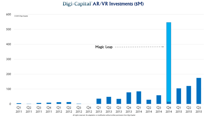
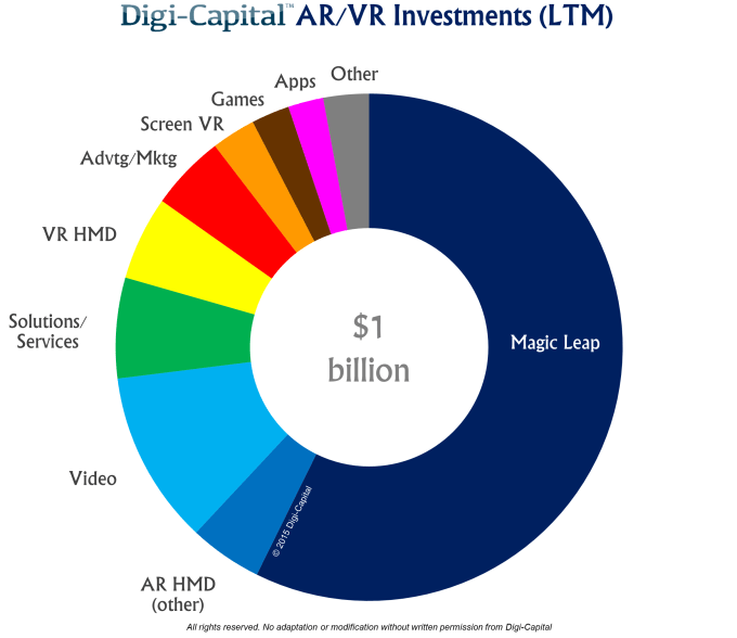
Magic Leap took more than half the money in the last 12 months, and there are reports that they’re raising another billion. VCs and corporates have also become excited beyond our Floridian friends, with an impressive diversity of investment in a market that hasn’t really launched yet.
There have been significant investments in AR/VR head-mounted displays, video, solutions/services, advertising/marketing, games and apps. As the ecosystem begins to take shape, the investment community is providing the fuel to take AR/VR skywards.
 Not An Exit Market Yet
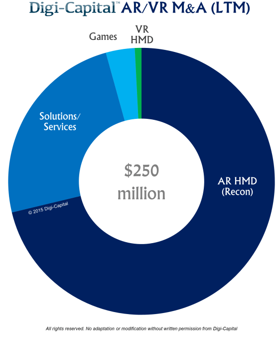
Facebook’s Oculus acquisition was another catalyst for investors and corporates, but there has been a bigger impact on investment than M&A so far.
The AR/VR market delivered $250 million of M&As in the last 12 months, with Intel buying Recon accounting for around three-quarters of the total. That could change dramatically next year, as major corporates try to leapfrog the competition through buying hot startups.
 Virtually Guaranteed To Be Augmented
With the AR/VR market beginning to launch, the investment community today is divided into true believers like Intel, Google, Facebook and Microsoft, and those taking a wait and see attitude.
There will be bumps in the road next year, but fortune favors the brave in early stage investment markets. When the market gets going and there are a few more chunky exits, it’s going to become increasingly hard for folks to stay on the sidelines.
Augmented/Virtual Tech, Real Investment
There was a slow trickle of AR/VR investments from 2006 until late 2014. Then Magic Leap raised $542 million from Google and others. This was the starting gun for investment accelerating, with nearly $1 billion poured into the sector in the last 12 months.
Last quarter alone saw more than 6x the investment in the market from Q2 2014. While VC and corporate communities are still developing an informed focus on the industry, their interest has never been higher.
Magic Leap took more than half the money in the last 12 months, and there are reports that they’re raising another billion. VCs and corporates have also become excited beyond our Floridian friends, with an impressive diversity of investment in a market that hasn’t really launched yet.
There have been significant investments in AR/VR head-mounted displays, video, solutions/services, advertising/marketing, games and apps. As the ecosystem begins to take shape, the investment community is providing the fuel to take AR/VR skywards.
Facebook’s Oculus acquisition was another catalyst for investors and corporates, but there has been a bigger impact on investment than M&A so far.
The AR/VR market delivered $250 million of M&As in the last 12 months, with Intel buying Recon accounting for around three-quarters of the total. That could change dramatically next year, as major corporates try to leapfrog the competition through buying hot startups.
With the AR/VR market beginning to launch, the investment community today is divided into true believers like Intel, Google, Facebook and Microsoft, and those taking a wait and see attitude.
There will be bumps in the road next year, but fortune favors the brave in early stage investment markets. When the market gets going and there are a few more chunky exits, it’s going to become increasingly hard for folks to stay on the sidelines.
Thursday, November 19, 2015
Towers and Corridor Patrol
Uploaded on Feb 20, 2015
This is video provided by Roger Dreyer, the California attorney in the lawsuit filed by Karen Allen that shows marked and unmarked towers in the area of the flight path that Steve Allen flew in 2011 that resulted in his untimely death after his ag aircraft collided with an unmarked Meteorological Evaluation Tower.


Saturday, November 7, 2015
Thursday, October 29, 2015


Wednesday, October 28, 2015
Four Channel HD and 4K multicamera recorder and switcher

A FMV Production Studio In The Palm Of Your Hand.

Convergent Design announces the perfect solution for all critical infrastructure patrols with gyrostablized multi-sensor gimbals or other multicamera or sensors. Red Hen is very encouraged that Convergent Design has presented this powerful 4K/HD DVR.
"Match this solid state video recorder with Red Hen Hen's VMS-333 spatial metadata multiplexor and encoder, and you have the most affordable solution for the emerging instrumented corrdor patrol missions... wire, pipe, rail, waterways and streets. The sDVR, spatial digital video recorder once a $40,000+ investment now can be configured for a fraction. This is a huge break-through in afforadability of Airborne & Mobile Geospatial Full Motion Video Recording Systems and Integrated GIS Software", decalerd Neil Havermale at Red Hen Systems.(Colorado Springs, CO) 10/28/15 – Today Convergent Design announces Apollo, the industry’s first truly portable HD multicamera recorder/switcher. Apollo can simultaneously record up to four HD video signals, along with a fifth channel of either a live-switch between the four or a quad-split reference view. Apollo can also function as a four-channel live switcher while simultaneously recording the four isolated HD video signals. The size of a small tablet and able to run for hours on a camcorder battery, Apollo is truly portable and the only device of its kind that can both record multiple HD camera feeds as well as live-switch between them. It’s a production studio in the palm of your hand.
- 7.7" 1280x800 OLED Touchscreen Monitor
- Four Input Switching and Recording
- Records to Convergent Design SSDs
- Compatible with Select Samsung SSDs
- HD Recording over SDI or HDMI
- ProRes Recording
- 3G-SDI Inputs/Outputs, HDMI In/Out
- Image Analysis Tools
- Built-in LUTs & Custom 3D LUT Support
- Program Camera Indication
Additional functions are planned for release in the first quarter of 2016, including two-channel 4K/UHD video recording, DNxHD recording, and cascade interconnect between up to three Apollos for up to twelve HD channel or six 4K/UHD channel simultaneous recording. These and other additional functions will be made available via a free firmware update. A remote keypad control unit will be offered along with a rack mount and other accessories.
For those owners of the 7Q/7Q+ recorders who are wondering what happened to the promised quad recording option? Apollo is it. In an interesting move the Apollo functionality will also be available to owners of the 7Q/7Q+ as a paid upgrade. From the outset Convergent Design told users quad recording was going to be a paid option and so this comes as little surprise. Although the price is not insignificant for what is essentially a firmware upgrade the company have added extra features such as the fifth screen recording, which is more that was originally promised.
Apollo is scheduled for release in December 2015. Manufacturer’s list is $3995, with an SSD to USB3 adapter, a 5-pack of SSD mounting handles, and a universal AC power supply included. Owners of the Convergent Design Odyssey7Q and Odyssey7Q+ will be able to purchase an Apollo Option for their devices as an upgrade for $1795.
News Shooter Apollo Earily Interview with Convergent


Monday, October 26, 2015
$200 Learners Permit for UAS

Perhaps you’re just beginning to explore the world of drones...or maybe you want to develop aerial photography skills that will help you take better pictures and videos. Whatever your goals, RealFlight Drone helps you achieve them quickly and safely. Learn to maneuver your drone for impressive aerial photos. Develop FPV camera and gimbal control skills to find the best angles. Protect your drone and camera investments by mastering new skills without risk on your PC!

The InterLink Elite works like a real, high-quality drone flight transmitter and has the same controls — even digital trims. No batteries or complicated setup are required. The controller operates all software functions, so you won’t have to juggle your keyboard and mouse. If you already own an R/C transmitter, you may also be able to fly your drone simulations with it using the InterLink Elite’s built-in interface.
U.S. Patent #7,010,628 U.S. Patent #6,482,804
Master flight with helpful tools

Develop flight agility skills to be ready for all occasions.

Maneuver into the best position in the Scavenger Hunt challenge.

Maneuver into the best position in the Scavenger Hunt challenge


Practice in a variety of conditions, such as day or night.

Maneuver into the best position in the Scavenger Hunt challenge.

Control the camera to frame each scene from a “drone’s eye view.”
Wednesday, October 21, 2015
Oh the places you will go....

People get ready. Virtual tourism is about to take wing. Will you be visiting far-away places in the Christmas season? Simply VRing around our Earth and dozens of offerings of VR goggles: Occulus, Cardboard , VR Gear, and others. And something very, very exciting will also be soon found at Google... to help make your Holiday Season a Google one? What a cool way to build a suprise vacation?
Take the ride! Be inspired! I am goint on a trip even this day... Mermaid Island, Malaysia. Heck you too might even Dropin and Hangout - we can take a walk about together?
Alphabet - E is for ....?

Friday, October 16, 2015
Thursday, October 15, 2015
Anti-Drone Radio/GPS Disruptor
Anti-drone rifle shoots down UAVs with radio waves
by Andrew Tarantola | @terrortola | 15 Hours Ago

While the US military continues to develop new and awesome ways of blowing aerial drones to smithereens, not many of these systems can easily be adapted to use in the civilian realm. That's why Battelle has developed the DroneDefender, a shoulder-mounted rifle that knocks UAVs offline with a barrage of radio waves.
"It can help us in numerous settings, from the White House lawn to bases and embassies overseas; from prisons and schools to historic sites,"Alex Morrow, technical director on the project, said in a statement. "It easily and reliably neutralizes the threat." The weapon weighs roughly 10 pounds and can target drones up to 400 meters away. When the trigger is pulled, the gun emits a blast of electromagnetic energy tuned to the most common GPS and ISM frequencies, safely disabling the drone and preventing it from accepting any additional commands from its operator. This is especially helpful if the drone is equipped with an improvised explosive device.
Wednesday, October 14, 2015
Thursday, October 8, 2015
Amazon Launches Snowball, A Rugged Storage Appliance For Importing Data To AWS By FedEx Poex Story
AWS Introduces Kinesis Firehose To Move Sensor Data To Cloud
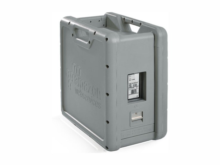
Amazon surprised developers today with the launch of Snowball, a new physical appliance that will allow AWS users to ship huge amounts of data for import into AWS by shipping the device back and forth between their offices and the AWS data centers.
The appliance is a bit larger than an old-school desktop case and it can hold up to 50 terabytes of data. It has a Kindle on the side, which functions as an automatic shipping label.
Amazon says the case can withstand a 6 G jolt and is entirely self-contained, with a 110-volt power supply and 10 GB network connection built-in.
Every import/export job will cost developers $200. The first 10 days of onsite usage are free, each extra day on site will cost developers $15 days. Amazon won’t charge for importing the data from Snowball into S3, but it will charge $0.03 per GB for export.
After the user sets up a Snowball job on AWS, Amazon will ship them a Snowball appliance. They then import their data into the appliance and ship it back to Amazon, with the built-in Kindle functioning as the shipping label.
For now, all of the data from Snowball appliances will be uploaded into S3 Standard in Amazon’s Oregon data center — support for other data centers is coming soon.

Wednesday, August 26, 2015
Thursday, August 20, 2015
CH4 or CH$?
Why Obama’s Proposal to Slash Methane Emissions Is a Really Big Deal

The Obama administration announced yet another blockbuster climate change reform on Tuesday morning: the first-ever federal proposal to significantly cut methane emissions from the oil and natural gas industry.
The rule will also set limits on the release of volatile organic carbons, a key precursor of ozone pollution, from "new and modified" gas facilities and pipelines as well as from fracking wells, notorious for spewing methane andozone pollution.
Methane is the primary component of natural gas and a fierce driver of climate change. Though it doesn’t linger in the atmosphere for as long as carbon dioxide, its more-discussed counterpart, it is far more heat-trapping in the short term; in its first 20 years in the atmosphere, methane's climate-warming impact is at least 84 times that of CO2. Over a 100-year period, its impact is still 20 times greater than CO2.
Try Newsweek for only $1.25 per week
According to data compiled by the Environmental Defense Fund (EDF), around 25 percent of global warming experienced today is the direct result of methane emissions. In a statement emailed Tuesday, the U.S. Environmental Protection Agency (EPA) says it estimates its new rule will "yield net climate benefits of $120 million to $150 million in 2025."
“Today, through our cost-effective proposed standards, we are underscoring our commitment to reducing the pollution-fueling climate change and protecting public health while supporting responsible energy development, transparency and accountability,” EPA Administrator Gina McCarthy said in a statement.
The EPA proposal, which has been in the works since at least January, calls for a steep 40 to 45 percent cut in national methane emissions from 2012 levels within the next 10 years, by way of tighter rules meant to prevent methane from escaping from pipes and compression facilities. The rules, however, are mandatory for only new and modified facilities, and voluntary for pre-existing ones.
The oil and gas industry says it has a natural incentive to voluntarily update its systems, since lost methane translates into lost product and lost revenue. But environmental groups like the EDF say that performance under past programs proves that, in practice, that turns out to be not the case.
"EPA has now run a voluntary program for reducing methane emissions from the oil and gas industry for the past 20 years, and frankly 99 percent of industry has failed to step up to the plate to participate," Mark Brownstein, vice president of EDF’s climate and energy program, told InsideClimate News. "It is naive to think that all [oil and gas producers] are simply going to sign up to do what's right absent some prodding from federal and state regulation."
The nation’s natural gas production and transportation infrastructure is notoriously riddled with leaks. According to a study published Tuesday in the journal Environmental Science and Technology, natural gas facilities lose about 100 billion cubic feet of natural gas each year, or eight times more than EPA estimates they do, The New York Times reports. Last year, Google’s Street View Cars partnered with the EDF to map methane emissions in a few American cities and found leaking pipes everywhere.
In many cases, methane leaks are cheap to fix, according to a 2014 study commissioned by the EDF. As InsideClimate News points out, that study found that the natural industry could cut methane emissions by 40 percent below projected 2018 levels at an average annual cost of less than $0.01 per 1,000 cubic feet of produced natural gas, an amount that today sells for approximately $3.
Wednesday, August 19, 2015
US Shutdown of DGPS ?
Nationwide Differential GPS Shutdown Proposed, Comments Sought

Twenty-two NDGPS sites that serve coastal areas would remain operational under the proposal.
The notice, issued by the U.S. Coast Guard (USCG), Transportation Department (DOT) and Corps of Engineers (USACE), reads:
The Nationwide Differential Global Positioning System (NDGPS) service augments GPS by providing increased accuracy and integrity using land-based reference stations to transmit correction messages over radiobeacon frequencies. The service was implemented through agreements between multiple federal agencies including the USCG, DOT, and Army Corps of Engineers, as well as several states and scientific organizations, all cooperating to provide the combined national DGPS utility.
However, a number of factors have contributed to declining use of NDGPS and, based on an assessment by the Department of Homeland Security, DOT and USACE. DHS, DOT and USACE are proposing to shut down and decommission 62 DGPS sites, which will leave 22 operational sites available to users in coastal areas.

A DGPS reference station antenna.
Contributing factors cited in the decision are:
- USCG changes in policy to allow aids to navigation (ATON) to be positioned with a GPS receiver using Receiver Autonomous Integrity Monitoring (RAIM), which assesses the integrity of a GPS signal within the receiver;
- increased use of Wide Area Augmentation System (WAAS) in commercial maritime applications, which uses ground-based reference stations and satellite communications to improve accuracy;
- limited availability of consumer-grade NDGPS receivers;
- no NDGPS mandatory carriage requirement on any vessel within U.S. territorial waters;
- the May 1, 2000 Presidential Directive discontinuing GPS Selective Availabilitycontinuing GPS modernization; and
- the DOT Federal Railroad Administration’s determination that NDGPS is not a requirement for the successful implementation of Positive Train Control (PTC), which provides the railway system the capability to positively enforce movement authorities along railroad systems.

In April 2013, announced that DHS and DOT were in the process of analyzing the need for NDGPS. “The response to the 2013 notice was limited, but the responses received were well informed on the NDGPS system, its use, and current and potential applications,” the notice reads. “While a limited number of responders found the broadcast of corrections to be beneficial, no respondents reported the discontinuance of DGPS broadcast to be detrimental or harmful. Ship pilots in particular noted that DGPS can be critical in confined waterways for precise ship-handling maneuvers.”
Public comments on the proposed shutdown and decommissioning of 62 DGPS sites are being accepted until Nov. 16. Termination of the NDGPS broadcast at these sites is planned to occur on Jan. 15, 2016.
Full details on how to submit public comments can be found on the Federal Register page.
Public comments on the proposed shutdown and decommissioning of 62 DGPS sites are being accepted until Nov. 16. Termination of the NDGPS broadcast at these sites is planned to occur on Jan. 15, 2016.
Full details on how to submit public comments can be found on the Federal Register page.
Friday, July 17, 2015
Wednesday, July 8, 2015
Google's DeepStereo makes Street View 'tourism' more realistic

Who here uses Street View to do some virtual traveling? It's not a shabby option if you want to look at places you might never visit within your lifetime, but Google thinks there's still a better way to simulate real-world tours. A team of the company's researchers has developed a technique that uses Google's experimental machine vision algorithm called DeepStereo to transform Street View panoramas into seamless virtual tours. See, Street View photos don't usually capture every detail of a location -- there are always a few frames missing in order to construct convincing digital reproductions of places like museums and houses. DeepStereo can synthesize those missing frames based on the ones that go before and after them, giving Google the ability to create realistic virtual tours.
In order to "train" DeepStero, the team had to feed the algorithm with images captured out of a moving vehicle; after that, it was able to start recreating images. It's still not perfect at this point -- some objects like trees or grass are hard to synthesize and details vanish from the recreated frame if the machine lacks pertinent details. In addition, it takes as long as 12 minutes on a powerful workstation to build a single synthetic frame. DeepStereo's obviously still a young technology, but the team believes it could be used not just to create virtual tours, but to generate environments for movies and virtual reality content in the future.
Monday, July 6, 2015

Mobile GeoInt
On the National Geospatial-Intelligence Agency (NGA) app store, users can empower their hand-held devices to warn against hostile maritime events, access geotagged text and photos for situational awareness, tap into aeronautical charts, and stream video in real time.
Every day, planners are finding new ways to bring vital geospatial data down to mobile devices at the tactical level. Still, tactical mobility is far from being a done deal when it comes to GEOINT.
Bonus: The Army's Dr. Joseph Fontanella discussed the challenges of disseminating geospatial data to disadvantaged troops during a June 3 C4ISR & Networks webcast. The on-demand version of the event is available now. Click here for more.
Despite the plethora of apps already available, technology gurus at NGA, as well as leaders in satellite data on the commercial side, agree there is much work to be done. But the results, if successful, could be substantial.
Exploring new devices
Before he'll even talk about diverse emerging mobility hardware, NGA Mobile Apps Team Lead Ben Tuttle needs to say a couple of words about whether battery life is adequate: Not yet.
The problem is a longstanding one. Mobile devices eat battery life, and the more powerful the devices get, the faster the battery drains. Today's handhelds can stream audio and download detailed imagery, but at what price? "Once we start taking advantage of these processors, we start draining the battery," Tuttle said.
Engineers can't fix it: The laws of physics keep getting in the way. It's a problem that will be around for a while.
That's the bad news. From there, things start to get better. The apps are here, and now the devices are getting better. They are uniformly cool, and the GEOINT field is exploring how to best take advantage oftheir new features.
Take, for instance, Internet-enabled eyewear such as Google Glass. They offer a version of augmented reality, layering data on top of images. Look at a building, see when it was built. Look at an enemy position, see at a glance all available GEOINT.
They're interesting, Tuttle said, because they could allow the war fighter to keep eyes on a scene, absorbing critical information without having to look away at some other device. That's the promise of mobility after all: to take it with you and put it easily to use. Such goggles could potentially take that a step further, integrating GEOINT seamlessly into the tactical experience.
Engineers are still working out the kinks. Early versions are a little delicate for tactical use. They're also too obtrusive for someone not eager to stand out in the crowd. At $5,000 they also are a pricey proposition as compared to the next up-and-coming wearable: smart watches. The Apple Watch models start at $350.
Tuttle likes the watch not for how much data it can pull down, but for how easily it can deliver. "I don't think you will look at a map on a watch," he said. What a user might do is glance down to see that a new message about changing scenarios on the ground has arrived. If it seems worth learning more information about, that user might pull out a phone or tablet to get the details.
It's a compact device and takes little power, easing the battery issue. Tuttle's office is looking into it.
Shrinking the data
New devices bring new questions, said Paul Millhouse, director of technical solutions at satellite imagery provider DigitalGlobe.
Today's wealth of satellite data has been described as a firehose problem. GEOINT is so incredibly rich, and uses bandwidth so intensively, it's impractical to point it at a mobile device and start blasting away. The device could never take it all in. "Any kind of solution you are looking at for GEOINT is inevitably going to have to deal with that," Millhouse said.
Managing the emerging landscape of mobile GEOINT, and its attendant bandwidth problem, will require tools that can bring only the needed information down to the soldier, rather than trying to cram the entire mass of intelligence down the pipe, Millhouse said.
DigitalGlobe's present strategy has been to thin the stream from terabytes down to kilobytes by buffering it in the commercial cloud, and then streaming out only the most relevant, actionable data. In large measure, this technique involves managing imagery. Suppose ground forces need an image of a helicopter landing zone. Rather than push down a map depicting multiple square miles, analysts can process data in the cloud and send out only the necessary, narrow sliver of data troops need to act on.
In some such cases automation helps to bring mobility to GEOINT. Cloud-based analytics can identify relevant objects and thin out data accordingly, making it more readily available for mobile devices.
Integration is another key. By processing data in the cloud, rather than on the device, it's possible to create analytic overlays that combine a landing zone, radio propagation and line-of-sight analysis. Without this preprocessing, mobile devices would not have the computer power to make such specialized use of GEOINT.
Compressing and combining the data serves a vital tactical function, Millhouse said, by giving soldiers ready-access to GEOINT even when they are outside the realm of mobile connectivity.
When data has been cleaned up and streamlined, it can be cached into a mobile device, "so now when they are disconnected, they still have access to the same set of information," he said. In tactical situations that ability to have continued access to maps, imagery and other data has long been the promise of mobility. It's also been a challenge, as engineers work out how to get significant volumes of data to reside on inherently limited devices.
Looking ahead
Running in the background of these efforts is the constant refrain of GEOINT: security. As far as military planners are concerned, nothing can ever be secure enough. When it comes to mobility, that goes double.
"There is still a learning curve," Tuttle said. "People have established how we define security for the old system, and they don't yet know what that is going to be for this [mobile] system. They are having to wrap their heads around it, and sometimes it's scary."
With no easy answer on that score, NGA is pressing ahead with its efforts. On any given day there are hundreds of people in the security, tactical and urban search-and-rescue fields running GEOINT on diverse mobile devices, prototyping future possible uses, Tuttle said.
Wearables aren't actively in the mix yet, but their moment of deployment is likely not far from now. "We are exploring them. We see some value proposition and we are looking at the strengths and weaknesses," Tuttle said. "We are hearing from the consumer: This is something we want to use."
Not that long ago, Tuttle was hearing the same thing about phones and tablets. Even as the military moves toward the next generation of wearable mobility, GEOINT still is settling into a rhythm when it comes to the use of these more conventional devices.
Certainly those in the field like the ready-access to information, Tuttle said. But it's hard to carry a rifle and a tablet, just as it is hard to read a map on a phone. So there are physical limitations. Still, the prospect of near-real-time information sharing in the field continues to make these products enticing.
Even as issues of form factor get worked out, Tuttle predicted, functionality in the mobile space will continue to drive interest. When data is not just mobile, but interactive, then the GEOINT community will really be making headway — be it on tablet, phone or any other device. "People want their maps, but they also want to create stuff on the maps," he said.
Attach a voice or video recording to a map. Draw on the map before sharing it. Now mobility starts to get interesting.
Monday, June 15, 2015
GoPro in The Clouds???

GoPro doesn’t want to be known just as a camera company.
Instead, as I learned from GoPro’s CEO and Founder Nick Woodman, GoPro wants to
be a lifestyle media company. To that end, the company is looking to cloud
services to give owners an easier way to share all that rad action footage and
build a new business based on content, not hardware.
GoPro cameras are designed to survive the harshest
conditions possible. Yet they suffer from the same fundamental flaw as
traditional cameras: content gets stuck on the SD cards inside the cameras.
Smartphones address this problem by allowing pictures and videos to be shared
instantly but users still have to go through several steps to share content,
something Nick Woodman aims to reduce.
On the eve of the GoPro Mountain Games in Vail, Colo., I had
the chance to sit down with GoPro founder and CEO Nick Woodman. He laments the
content that gets stuck on his devices. He admitted that he has this problem,
too. Like many of his customers (me included), he has stacks of SD cards with
footage that he doesn’t have to time to edit. This is where the cloud services
come into play.
“GoPro has to build an iTunes type management system that
just works with people,” Nick said. “I didn’t realize that early on as a single
guy. As soon as I became a Dad I had no more time to manage the content. We are
sort of leaving our customers in a dark forest.”

Woodman stressed that GoPro’s cloud services are still in an
early development. It’s clear he’s excited about it and sees this solution
transforming his company from a camera maker to a media brand.
As Woodman explained it, when a camera is plugged in to be
charged, the service would upload the footage to a cloud service, eliminating
the tiresome task of manually transferring the data from an SD card into
editing software. From the cloud service, customers could edit the footage and
share it. Woodman also hinted that there could be a feature where long videos
are cut into highlight reels, which if implemented, would facilitate more
shared footage and that’s what GoPro wants.
As an example, he explained that in the future GoPro
customers wouldn’t save the recorded the footage with a GoPro camera, but
rather use the GoPro service to make unique content to share. The distinction
is key.
Right now, people use GoPro cameras. Woodman hopes, with
this cloud service, people will simply use GoPro.
“When we do this, people will think of GoPro in whole new
way,” Woodman said.
He views this ability to be more relevant to parents and
kids. When the cameras are connected to a cloud account, footage will no longer
be stuck on a media card until the owner decides to do something with it. He
believes this cloud service will drive more camera sales as suddenly owners
will be able to enjoy the captured footage more easily.
This cloud service should provide GoPro with deep insights
to their customers. Nick explained that GoPro currently does not have data on
their customer’s demographics or usage patterns.
“You don’t yet register a camera with GoPro,” Woodman said.
“You can, but there isn’t much of a value proposition for you to do so. But
when the value proposition is you can register your camera to a cloud account,
the amount of data we can get to better serve them will be massive.”
“We know very little about our customer,” he said. “Which
the good thing is it tells you how broadly appealing this whole ‘I just want to
capture the experience and those around me’ movement is and how well we’re
doing. It’s not like we’re having to home in and look at very specific customer
groups to drive growth.”
But if the company can get customers to connect their camera
to cloud, GoPro should be flooded with a torrent of data — and securing that
data could be the company’s next big challenge.
As a hardware company, GoPro simply needs to sell cameras.
It doesn’t have to worry about data breaches or privacy control. These items become
paramount if GoPro rolls out a cloud service like the one Woodman explained.
Suddenly, GoPro is tasked with selling cameras and storing gobs of personal
data, which will turn the company into a massive target.
I asked which company GoPro is partnering with for data
storage and Woodman returned a “no comment” response.
I asked which company GoPro is partnering with for data
storage and Woodman returned a “no comment” response.
Woodman wouldn’t reveal specific details about how a GoPro
cloud service would work. It’s unlikely that GoPro would want to store full
resolution files. More likely, resolutions and frame rates would be reduced to
formats well suited for mobile viewing. GoPro recently released a
wireless add-on that allows GoPro cameras to stream content directly to
broadcasters — it’s likely that future high-end GoPro cameras will include this
ability while the rest of the product line will have Bluetooth and WiFi
capabilities.
One thing is clear: the experience needs to be perfect. If
done right and launched in a timely fashion, it could be a boon for GoPro’s
growth and ultimate security from smartphones eroding its market. But if
launched prematurely with lackluster security, it could be company’s undoing.
It’s up to Woodman to make sure that doesn’t happen.
Monday, June 8, 2015
Samsun S6 Active - Bigger battery and can swim in the river
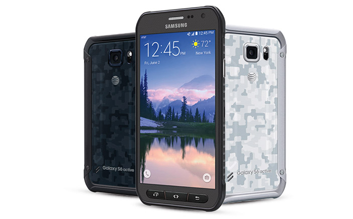
The Galaxy S6 Active has virtually the same specs as the standard Galaxy S6 including a 5.1-inch 1440p Super AMOLED, 16MP camera, 32GB of storage, and Android 5.0.2. The heftier design does allow for a much larger battery at 3500mAh. The regular Galaxy S6 is just 2550mAh (2600 in the Edge).
The device will go on sale on June 12th for for $23.17 with 30 device payments on Next 24, $28.96 per month at 24 payments on Next 18, or $34.75 per month at 20 payments on Next 12. That works out to about $700 full price, so you can expect a $200 on-contract price as well.
Cardboard for the Millions
https://www.google.com/get/cardboard/get-cardboard/
Google intros new
Jump VR platform
and improved
Cardboard


Subscribe to:
Posts (Atom)