Showing posts with label LDAR. Show all posts

Thursday, August 20, 2015

CH4 or CH$?

Why Obama’s Proposal to Slash Methane Emissions Is a Really Big Deal

EPA Proposes First Federal Methane Emissions Rules
A sign marking the location of a natural gas pipeline in Golden, Colorado, on February 2, 2015. RICK WILKING/REUTERS
FILED UNDER: Tech & Science


The Obama administration announced yet another blockbuster climate change reform on Tuesday morning: the first-ever federal proposal to significantly cut methane emissions from the oil and natural gas industry.

The rule will also set limits on the release of volatile organic carbons, a key precursor of ozone pollution, from "new and modified" gas facilities and pipelines as well as from fracking wells, notorious for spewing methane andozone pollution.

Methane is the primary component of natural gas and a fierce driver of climate change. Though it doesn’t linger in the atmosphere for as long as carbon dioxide, its more-discussed counterpart, it is far more heat-trapping in the short term; in its first 20 years in the atmosphere, methane's climate-warming impact is at least 84 times that of CO2. Over a 100-year period, its impact is still 20 times greater than CO2.

Try Newsweek for only $1.25 per week

According to data compiled by the Environmental Defense Fund (EDF), around 25 percent of global warming experienced today is the direct result of methane emissions. In a statement emailed Tuesday, the U.S. Environmental Protection Agency (EPA) says it estimates its new rule will "yield net climate benefits of $120 million to $150 million in 2025."

“Today, through our cost-effective proposed standards, we are underscoring our commitment to reducing the pollution-fueling climate change and protecting public health while supporting responsible energy development, transparency and accountability,” EPA Administrator Gina McCarthy said in a statement.

The EPA proposal, which has been in the works since at least January, calls for a steep 40 to 45 percent cut in national methane emissions from 2012 levels within the next 10 years, by way of tighter rules meant to prevent methane from escaping from pipes and compression facilities. The rules, however, are mandatory for only new and modified facilities, and voluntary for pre-existing ones.

The oil and gas industry says it has a natural incentive to voluntarily update its systems, since lost methane translates into lost product and lost revenue. But environmental groups like the EDF say that performance under past programs proves that, in practice, that turns out to be not the case.

"EPA has now run a voluntary program for reducing methane emissions from the oil and gas industry for the past 20 years, and frankly 99 percent of industry has failed to step up to the plate to participate," Mark Brownstein, vice president of EDF’s climate and energy program, told InsideClimate News. "It is naive to think that all [oil and gas producers] are simply going to sign up to do what's right absent some prodding from federal and state regulation."

The nation’s natural gas production and transportation infrastructure is notoriously riddled with leaks. According to a study published Tuesday in the journal Environmental Science and Technology, natural gas facilities lose about 100 billion cubic feet of natural gas each year, or eight times more than EPA estimates they do, The New York Times reports. Last year, Google’s Street View Cars partnered with the EDF to map methane emissions in a few American cities and found leaking pipes everywhere.

In many cases, methane leaks are cheap to fix, according to a 2014 study commissioned by the EDF. As InsideClimate News points out, that study found that the natural industry could cut methane emissions by 40 percent below projected 2018 levels at an average annual cost of less than $0.01 per 1,000 cubic feet of produced natural gas, an amount that today sells for approximately $3.

Saturday, September 27, 2014

GAS Anadarko

Bridging the generation gap for spatially-enabled asset management

DSC03331ab

I've blogged many times about the aging workforce challenge facing many industries.  At the SPAR International conference Wayne Rodieck of Anadarko Petroleum outlined what this means to the oil and gas industry and how he is using IT to bridge the generation gap.

The International Energy Agency (IEA) is projecting that by 2020 the U.S. will surpass Saudi Arabia as the world's largest oil producer.  US oil and gas production, driven by technologies that are unlocking light tight oil and shale  gas resources, is rising dramatically.  Since 2008 the U.S. oil and gas industry has increased production by 25%.  This expansion has created 1.7 million new jobs.

DSC03328ab

Most of these have been filled by young workers with no or little experience in oil and gas, but better acquainted with IT technology than the experienced workers who are on the verge of retirement.  As with other industries oil and gas is faced with the challenge of knowledge transfer to enable younger workers to be as productive as possible and to avoid a massive decline in productivity as the older generation retires.

Dr Apostol Panayotov of UC Denver described an online spatially-enabled asset information system at Anadarko that is designed to be accessible to both generations.

  DSC03330ab

It provides a web-based user interface designed to serve up information about equipment on oil and gas facility sites including visual photographs, facility attributes and gelocation.  It is based around point clouds captured by scanning valves, pumping stations, and other oil and gas pipeline infrastructure, but it hides the point cloud behind an intuitive interface that relies on smart digital photographs of facilities.  Clicking on a particular piece of equipment such as a valve, tank, or catwalk in a digital photograph links the user to information about that piece of equipment including geo-location and dimensions, information that is derived from a point cloud.

Wayne described a simple use case which explains what he sees as the critical advantage of this approach.  There is an emergency and at 2:30 am he has to send a young, inexperienced worker out to a site where there are a 120 valves to turn off one of them.  He feels confident that by providing the young worker access to this intuitive online system that he will turn off the right one.

Wednesday, May 21, 2014

ebee - Swiss quality


The eBee Ag is lightweight and highly durable and features a wide range of camera options and fully autonomous operation – flying, acquiring images, and landing itself.
“The eBee Ag enables growers and coop consultants to become much more precise in their work,” says Jean-Christophe Zufferey, C.E.O. of senseFly. “The detail provided by its customised cameras and its software’s index calculations allow customers to analyse crop conditions remotely and in high detail. This means less time wasted on manual checks and less reliance on low-resolution satellite images or costly airplane shots. With the accurate and timely data the eBee Ag supplies, farmers can optimise their crop management and chemical usage – saving them time, saving them money, and helping them boost their yields.”

eBee Ag Features:

1. Wide choice of cameras
The eBee Ag features a range of camera options to suit different applications, from biomass estimation to yield monitoring and leaf area indexing. It is supplied with a customized Canon S110 NIR, however customers can also choose a customised S110 RE (red edge) version, a S110 RGB, or the Airinov multiSPEC 4C (offering four distinct bands with no spectral overlap).

2. Reliable
The eBee Ag’s onboard artificial intelligence and robust lightweight construction ensure it will survive numerous flights (and landings), thus safeguarding a customer’s investment.

3. Easy to use
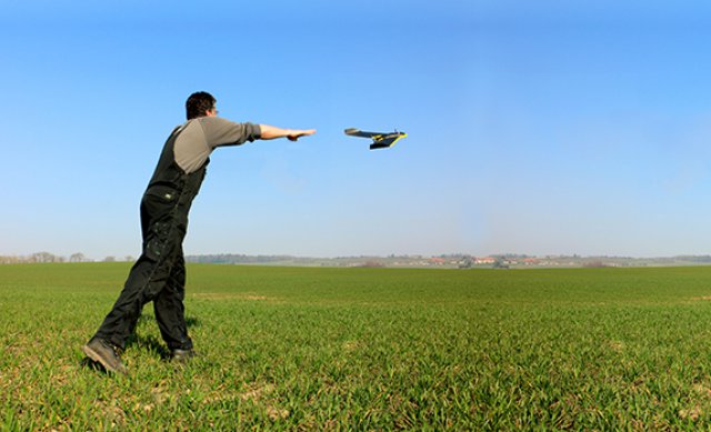
The eBee Ag is a fully autonomous drone. Customers simply select the area they want to map (using the supplied eMotion 2 software), launch the drone by throwing it into the air, and the eBee flies, acquires images, and lands all by itself.

4. Complete solution
The eBee Ag is supplied with two advanced software packages: eMotion 2 for flight planning and control; and Postflight Terra 3D photogrammetry software for post-flight image processing and analysis. Postflight Terra 3D can be used to produce false-colour orthomosaics and 3D models. Plus it includes a handy index computation tab, which allows customers to select a band, calculate NDVI, or input custom formulas in order to create the exact maps they require.

With its maximum flight time of 45 minutes, the eBee Ag can photograph areas of up to 1,000 ha (2,470 ac) in a single flight. Its default 12 MP NIR camera is capable of shooting aerial imagery at down to 2 cm (0.7 in) / pixel. These images are then easily transformed into false-colour orthomosaics using Postflight Terra 3D software, with accuracy of down to 3 cm (1.18 in). This market-leading performance brings farmers the data they need to monitor crops more precisely, feed other precision agriculture technologies, and continue improving their management decisions.

Availability: The eBee Ag is available to order from mid-April, 2014 via senseFly’s network of approved resellers.

- See more at: http://www.uasvision.com/2014/04/17/sensefly-announces-ebee-ag-aerial-imaging-uas-for-precision-agriculture/#sthash.yiR5WZJI.dpuf