Friday, June 29, 2012
Thursday, June 28, 2012
Android Goes Secure
Thousands of installs testing 'beyond the wire' in Afghanistan
Fairfax, Va. contractor Invincea, known for malware detection and network security, has been awarded a $21.4 million contract to find a way to secure Android. The Defense Advanced Research Projects Agency (DARPA), and the US Army Research Laboratory (ARL) sought development teams to secure the smartphone and tablet OS for military use in an initiative called "Mobile Armor." Invincea is planning on migrating developments in its research to commercial and consumer products as well.
Physical loss of the device is a concern. "They [DARPA] are really worried about loss of the device," says Invincea CEO Anup Ghosh. "God forbid you are captured and you lose the device that way." Early versions of the security-centric modified Android core are being tested in Afghanistan. Invincea is focusing on controlling access to the device so that only pre-selected applications can run. The "white list" approach narrows the focus of the second aspect of the security program, detecting attacks that attempt to exploit the approved applications and limiting the damage of those attacks.
While Apple has been considered amongst the most secure of mobile devices and a candidate for US military use, the company refused to divulge the source code for governmental modification. Without the source code, changes demanded by the military and federal staffers using the devices couldn't be made. The NSA also has a custom version of Android with similar, but not identical, security features to the Invincea product.
While Apple has been considered amongst the most secure of mobile devices and a candidate for US military use, the company refused to divulge the source code for governmental modification. Without the source code, changes demanded by the military and federal staffers using the devices couldn't be made. The NSA also has a custom version of Android with similar, but not identical, security features to the Invincea product.
Read more: http://www.electronista.com/articles/12/06/26/thousands.of.installs.testing.beyond.the.wire.in.afghanistan/#ixzz1z6L4hIsV
Defense Advanced Research Projects Agency (DARPA) Awards Invincea $21.4 Million Contract to Create Secure Android Smartphones and Tablets for U.S. Army
Posted on June 25, 2012 in Press Releases
Secure Android phones and tablets currently in field test in Afghanistan by U.S. Army brigade
FAIRFAX, VA – June 25, 2012 – Invincea, Inc., an innovator in advanced malware threat detection, network breach prevention, and pre-breach forensic intelligence, today announced the award of a multi-year, $21.4 million contract from Defense Advanced Research Projects Agency (DARPA) and the U.S. Army Research Laboratory (ARL) for the development of secure smartphone and tablet mobile platforms for military use. Dubbed “Mobile Armour,” the project focuses specifically on driving security innovation within the Android operating system for government use. Invincea expects this development will be a forerunner of innovation to be brought to the commercial and consumer sectors as well.
Through its Invincea Labs subsidiary, the company has pioneered the development of a secure Android-based operating system for tactical mobile devices used by soldiers in forward-deployed operations in enemy terrain. Initial versions of the secure Android phone and tablets, meeting stringent military security specifications for “outside the wire” tactical use, are already being field tested by thousands of U.S. Army personnel in Afghanistan. Based on this early success, DARPA and the U.S. Army are expanding the scope of the Mobile Armour project to include significant new security enhancements to the Android platform through this award. Surging demand in the Federal Government for secure mobility is driving follow-on applications of the secure Android build for Invincea. The company is engaged with a number of federal civilian and defense agencies for the development and deployment of secure Android phones for both office and field applications.
“As mobile devices become a new fertile ground for adversaries, chief information security officers (CISOs) are increasingly placing mobile security on their strategic roadmaps. At the same time, they need to continue addressing serious problems they face today – such as an increase in spear phishing of their employees. Security vendors like Invincea that innovate to address today’s problems and drive research into future requirements such as mobile are strongly positioned to be long-term partners to government and commercial organizations,” said Wendy Nather, Research Director of the Enterprise Security Practice at The 451 Group.
“The investment by DARPA and the U.S. Army in the Mobile Armour project demonstrates the critical need for secure mobility. As government departments and agencies across the civilian and defense sectors shift their focus towards the use of mobile applications for executing their missions, they must be able to trust that these platforms are secure,” said Anup Ghosh, Founder and CEO at Invincea. “The selection of Invincea Labs by DARPA demonstrates Invincea’s innovation and leadership in the secure mobility space. The company will continue to lead the federal sector to secure mobile solutions. Invincea looks forward to carrying these innovations to the commercial sector as it has with its breach prevention platform for the enterprise.”
SONY goes Pro??
Sony teases ruggedly handsome 'action camera,' has GoPro in its sights

Continue reading Sony teases ruggedly handsome 'action camera,' has GoPro in its sights
Cell-phone Signal Boosters
FCC proposes new requirements for cell-signal boosters
 The Federal Communications Commission is proposing to change the rules governing cell-signal boosters. The agency is considering a detailed set of specifications for signal amplifiers, along with new requirements for users on the largely unregulated industry, according to Computer World. The main concern from carriers is interference caused through a signal overlap from the amplifiers. Customers may be asked to inform carriers of booster use, while the hardware could be required to reduce its power or shut down when not needed....
Adobe Cloud gets Lightroom Too...

Adobe has added Lightroom 4 to the list of apps available as part of a Creative Cloud subscription. The software is a RAW photo workflow tool aimed mainly at pro and hobbyist photographers, with some limited editing functions. Signing up for Creative Cloud lets people download Lightroom 4 as long as their membership is active.
Subscriptions cost $50 per month on a 12-month plan, or $75 month-to-month. Educational pricing is $30 per month; the same pricetag is available on an introductory basis to people who own Creative Suite 3 or later. Beyond Lightroom 4, subscriptions include access to any Creative Suite 6 app, 20GB of storage, integration with Adobe's mobile Touch apps, and downloads of some non-CS products such as Muse and Acrobat. In some cases updates should also be pushed out to Cloud subscribers before they get bundled into larger releases.
Read more: http://www.electronista.com/articles/12/06/26/joins.collection.of.cs6.apps.on.service/#ixzz1z6Gfe6uD
Monday, June 25, 2012
Army Smartphone Safety
Military hunting smartphone safety to hold off enemy bugs, spooks


Ah, smartphones -- the delightful little slates carry our contacts, our content -- even our cash, and they still fit right in our pockets. No surprise then, that a lost or stolen phone can be a minor disaster -- or a major security risk (just ask the President). Now that soldiers are packing them to send GPS coordinates or situational images in the field -- on top of using them at home -- DARPA has enlisted security company Invincea to fortify the devices. Its first effort, encrypting OS files and filling the memory of a lost phone with worthless data, has already been deployed to 3,000 troops in Afghanistan. Its next target is to cloister apps into virtual rooms within the OS, locking off access to sensitive parts of the phone like its GPS or contact lists. That would keep any nasty bits of malware from potentially gaining root privileges so soldiers can fight, and Facebook, without compromise.
Friday, June 22, 2012
Accidentially On Purpose
How I Accidentally Kickstarted the Domestic Drone Boom

Open source drones, like this ArduCopter Quad from 3D Robotics, now
outnumber military drones in the US. Photo: Misha Gravenor
At last year’s Paris Air Show, some of the hottest aircraft were the autonomous
unmanned helicopters—a few of them small enough to carry in one hand—
that would allow military buyers to put a camera in the sky anywhere, anytime.
Manufactured by major defense contractors, and ranging in design from a single-
bladed camcopter to four-bladed multicopters, these drones were being sold as
the future of warfare at prices in the tens to hundreds of thousands of dollars.
In May, at a different trade show, similar aircraft were once again the most
buzzed-about items on display. But this wasn’t another exhibition of military
hardware; instead, it was the Hobby Expo China in Beijing, where Chinese
manufacturers demo their newest and coolest toys. Companies like Shenzhen-based
DJI Innovations are selling drones with the same capability as the military ones,
sometimes for less than $1,000. These Chinese firms, in turn, are competing with
even cheaper drones created by amateurs around the world, who share their
designs for free in communities online. It’s safe to say that drones are the
first technology in history where the toy industry and hobbyists are beating the
military-industrial complex at its own game.
Look up into America’s skies today and you might just see one of these drones:
small, fully autonomous, and dirt-cheap. On any given weekend, someone’s
probably flying a real-life drone not far from your own personal airspace.
(They’re the ones looking at their laptops instead of their planes.) These personal
drones can do everything that military drones can, aside from blow up stuff.
Although they technically aren’t supposed to be used commercially in the US
(they also must stay below 400 feet, within visual line of sight, and away from
populated areas and airports),
the FAA is planning to officially allow commercial use starting in 2015.
What are all these amateurs doing with their drones? Like the early personal computers,
the main use at this point is experimentation—simple, geeky fun. But as personal
drones become more sophisticated and reliable, practical applications are emerging.
The film industry is already full of remotely piloted copters serving as camera
platforms, with a longer reach than booms as well as cheaper and safer operations
than manned helicopters. Some farmers now use drones for crop management,
creating aerial maps to optimize water and fertilizer distribution. And there are
countless scientific uses for drones, from watching algal blooms in the ocean to
low-altitude measurement of the solar reflectivity of the Amazon rain forest. Others
are using the craft for wildlife management, tracking endangered species and quietly
mapping out nesting areas that are in need of protection.
To give a sense of the scale of the personal drone movement, DIY Drones—an
online community that I founded in 2007 (more on that later)—has 26,000 members,
who fly drones that they either assemble themselves or buy premade from dozens
of companies that serve the amateur market. All told, there are probably around
1,000 new personal drones that take to the sky every month (3D Robotics, a company
I cofounded, is shipping more than 100 ArduPilot Megas a week); that figure
rivals the drone sales of the world’s top aerospace companies (in units, of course,
not dollars). And the personal drone industry is growing much faster.
Why? The reason is the same as with every other digital technology: a Moore’s-
law-style pace where performance regularly doubles while size and price plummet.
In fact, the Moore’s law of drone technology is currently accelerating, thanks to
the smartphone industry, which relies on the same components—sensors, optics,
batteries, and embedded processors—all of them growing smaller and faster
each year. Just as the 1970s saw the birth and rise of the personal computer, this
decade will see the ascendance of the personal drone. We’re entering the Drone Age.
Thursday, June 21, 2012
Night Vision Extends Nikon D800 Low-light Capability
|


Tuesday, June 19, 2012
Panasonic ToughPad A1 on sale August 2012
Panasonic's first Android-based 'toughpad' unveiled in Asia
June 20, 2012 - 12:00PM
Rough and tumble ... the Toughpad is waterproof, dustproof and shockproof. Photo: AP
Panasonic's first Android-based computer tablet designed for tough environments such as battlefields has been unveiled at a major regional telecom fair in Singapore.
It was the first time the "Panasonic Toughpad A1" was showcased in Asia, where company officials said there is a huge demand for such a rugged device.
It has already previewed in the United States and production will start later this year, company executives said.
Advertisement: Story continues below

Military-type ... the Panasonic Toughpad A1. Photo: AP
Satoshi Mizobata, a director at Panasonic's Toughbook Asia Pacific Group, said the device is the firm's first rugged tablet computer using the Android operating system.
Previous Panasonic "toughpads" use Windows.
"It's military-type," Mizobata said at the Panasonic booth at the CommunicAsia telecom trade expo that opened Tuesday. "It is water-proof, dust-proof and shock-proof."
The device weighs 0.97 kilogrammes and its 10.1-inch LCD display allows the user to read even under the sun while it is tough enough to withstand being dropped from a height of four feet (1.21 metres). It also has a nine-hour battery life.
Amos Tio, Southeast Asia general manager for Toughbook Asia Pacific Group, said the gadget will launch in the region in September and in the United States in August.
The rugged tablets are popular in industries such as defence, utilities and construction, as well as by workers in Asia's vast palm oil plantations, company executives said.
Monday, June 18, 2012
Nikon RAW ... Version Control
- Nikon UK posted a reminder that you should always use the latest Nikon software in order to avoid RAW files corruption:
"When RAW images captured with a Nikon digital SLR camera are transferred to a computer, viewed, or edited with an earlier version of Nikon software that does not support RAW images captured with the camera used, some RAW image data may be corrupted and handled incorrectly by the software."
Windshield Mounts Create Law
Windshield mounts illegal in 28 states?

In a surprising (and questionable) bit of gumshoe work, a POI Factory contributor has concluded that windshield mounts are illegal in 28 states and six Canadian provinces.
According to the article, windshield mounting is against the law in the states shown in red, and limited placement is allowed in specific windshield zones in the states in yellow. Green should mean you’re good to go, but I’d take it all with a grain of salt. The commenters on one site linking to the post found quite a few errors and/or misinterpretations. If you have questions, I’d advise you to follow the links below and read the law for yourself.
As for me, I prefer friction/dashboard mounts
Key
Yes - Green - GPS receivers can be mounted on the windshield. This is either through being specifically mentioned as being exempt from a regulation, or through the law not specifically mentioning GPS receivers at all while mentioning other items as being prohibited. See the appropriate law for details.
Yes (Limited) - Yellow - As “Yes” above, but the law limits the location where the receiver may be mounted, usually at the bottom of the windshield in a 5″ square on the driver’s side or a 7″ square on the passenger’s side. See the appropriate law for details.
No - Red - GPS receivers may not be mounted on the windshield. This is generally because of a mention of “non-transparent material” not being allowed on the windshield. A GPS mount would fall under this definition. See the appropriate law for details.
Garmin Slow to Wake Up?

Apple Knocks Garmin’s Turnaround Story Off the Road
Garmin's comeback attempt seems to have fallen short
Assuming you’ve not been on a mission to Mars during the last couple of years, then you’re at least vaguely familiar with the phrase “There’s an app for that” — the running-joke-that’s-not-a-joke describing how smartphones like Apple’s (NASDAQ:AAPL) iPhone and Samsung’s Galaxy can be made to do anything from recognize a melody to serve as a voodoo doll.
Oh, and these smartphones can perform some more practical functions too. Just ask the folks at Garmin (NASDAQ:GRMN).
Prior to the advent of smartphones in 2007 with the debut of the first iPhone, Garmin was the name in portable global positioning systems (you know, GPS) and satellite-guided driving directions. However, once consumers started to realize smartphones could do the same — as well as play music, be a flashlight and even test the ripeness of a watermelon — the choice became something of a no-brainer: Smartphones win, and Garmin devices lose. The sales numbers and Garmin’s stock price since then have somewhat — though not radically — reflected that opinion.
Yet, knowing that all things are cyclical, one can’t help but wonder if the worst of the migration to smartphones as a GPS device is over. Said in plainer terms, could Garmin actually be a buy now?
Numbers Don’t Lie
In terms of earnings, Garmin’s best year ever was 2007. It cleared $3.80 per share that year, though the revenue peak was actually in 2008 with a top line of $3.5 billion. Either figure basically supports the notion that 2007 marked the beginning of the downturn, though, for stand-alone GPS as well as digital-roadmap devices. Both have fallen every year since then, save last year’s revenue, which was a tad better than 2010’s $2.69 billion.
The flipside: Although comparably capable smartphone usage has soared from zero in 2006 to the currently active user base of a little more than 1 billion (yes, 15% of the entire world’s population are smartphone users), not all of them have opted to use their phone over a devoted handheld GPS device. Indeed, surprisingly few of them have made the switch.
The proof of the pudding is in Garmin’s still-respectable numbers. Though last year’s $2.7 billion in sales is off the 2008 peak, it’s only 22% off that peak sales line. Even more compelling is the fact that unit sales are still accelerating for the company. Q1-2012’s 2.7 million devices sold was 7% better than the year-ago number, though the sale rate has been increasing for a couple of years.
But wasn’t the widespread adoption of smartphones supposed to obliterate the now-obsolete device? Yes it was, but no, it didn’t. This is where things get interesting for investors.
Not As Good?
Not that smartphones haven’t taken at least a little wind out of Garmin’s sails (and sales), but with three years to study the impact, perhaps the smartphone isn’t as big of a threat as first assumed.
Consumers aren’t shy about telling you why either. Though clever, the fact of the matter is, most smartphones can’t do what hardcore hikers, drivers and lost people really need done.
As for an explanation of why GPS device sales haven’t skyrocketed along with smartphones, that’s relatively simple, too. Mobile phones are viewed as, and almost deigned to be, consumables; techphiles wouldn’t be caught dead with yesteryear’s iPhone. Global positioning toys and satellite-linked dashboard maps, however, don’t become obsolete as quickly as phones do. All things considered, though, GPS equipment sales have held up surprisingly well compared to mobile phone sales.
Could it be Garmin has a prayer after all? That might have been the case until Monday.
The End of an Era, the End of a Company
You hate to see it happen, but then again, it’s not all that unusual.
Yesterday, Apple announced it would be using TomTom’s comparable GPS technology to power the related hardware in devices running its new operating system, iOS 6. In one fell swoop, the functionality gap that had so far been unfilled by tablets and smartphones — the gap filled by Garmins and Harman (NYSE:HAR) devices — was filled. As Apple’s Senior VP of the new operating system Scott Forstall described, it’s a “new mapping solution built from the ground up.” And sure enough, it is, complete with the all-important turn-by-turn navigation feature.
The question is, just how much of a blow is Apple’s new maps app to Garmin’s actual revenue? That’s the part that makes you wince.
Recognizing that sales in certain areas were waning, the company was in the midst of a deliberate effort to bolster sales in the arena Apple just likely commandeered, crimping one of its last remaining lifelines. Ironically, had the company not waded into those waters and focused so deeply on the automotive market, and instead developed the daylights out of the sporting and high-end usage markets (like hiking and airplane and aquatic navigation), it’s a conversation that might be moot now. Ugh.
Garmin has publicly stated it doesn’t see Apple’s decision as a problem, though the rebuttal sounds and feels a little desperate, with a dose of denial. And it’s too bad, as Garmin was just starting to look like a decent turnaround story.
Now it doesn’t.
Tuesday, June 12, 2012
SONY goes Swimming... 1080p-60 Record


SONY ADDS SLEEK WATERPROOF HANDYCAM® CAMCORDER TO ITS PORTFOLIO OF HIGH DEFINITION VIDEO CAPTURE DEVICES
SAN DIEGO, June 5, 2012 – Sony today unveiled a first for its lineup of Handycam® camcorders – a waterproof model that makes capturing your precious memories in high-quality video or still photography easy and worry-free in almost any environment.
The new HDR-GW77V camcorder can capture full HD video and 20.4-megapixel photos in extreme conditions, so that indoors or out, this stylish compact camcorder can keep up with any family’s active lifestyle. Waterproof down to 16 feet, the camcorder’s 3.0” (16:9) Xtra Fine LCD™ touch screen (921K) remains fully operational when submerged and it also has an “Underwater Mode” which adjusts the white balance for underwater conditions to make colors appear natural.
Sony’s latest camcorder addition is not only convenient to use in wet surroundings, it is also shockproof and dustproof making it durable enough to withstand an accidental drop from up to approximately 5 feet and suitable for just about any situation. From mountains and forests to pools and beaches, now users can document their adventures without stress anywhere and anytime, even if they face mud, snow, rain or grime while shooting.
 “As we continue to reinvent the category, we’re always looking for ways to make capturing memories hassle- and worry-free without sacrificing style,” said Hidenori Toyoda, director of the camcorder business at Sony Electronics. “This lightweight waterproof Handycam camcorder sports an innovative design and allows consumers to focus on the moment rather than fret over protecting their gadget.”
Slick, Durable and Feature-Packed
To help realize high-quality video and photos, the waterproof camcorder was developed with advanced technology. Its back-illuminated Exmor® R CMOS sensor improves image clarity and drastically reduces grain to capture beautifully detailed, low-noise footage even in low-light conditions. If needed, a built-in flash will shed light on your subject in dark areas.
For the first time, Sony introduces Intelligent Sweep Panorama™ mode for still photo into the camcorder family. The popular feature found in Sony Cyber-shot® cameras reaches beyond the traditional wide angle lens and lets you capture expansive, breathtaking shots of landscapes or cityscapes just by pressing the shutter button and panning the scene with a sweeping movement. Using Face and Motion Detection, even people and objects that are moving will be reproduced naturally without blur.
 The Extended Zoom feature digitally boosts the camcorder’s 10x optical zoom range to a powerful 17x maximum magnification, letting users get even closer to the action while maintaining HD image quality. And with 16GB of embedded Flash memory, it can record and store up to 4 hours of high definition video content (HD LP mode).
 Another standout feature is Optical SteadyShot™ image stabilization with Active Mode which compensates for greater degrees of camera shake to deliver stunningly smooth video from wide angle to full telephoto shooting. To further balance movement, 3-Way Shake-Canceling adds electronic roll stability for even smoother video capture.
Along with these features, the high-end camcorder offers the best of Sony imaging with its professional-quality G Lens. Engineered for superior optical performance, Sony G lenses deliver brilliant, accurate color reproduction and sharp, detailed images. In addition, the 29.8mm focal length in Photo Mode and Video Modes offers a broader perspective for enhanced wide angle shooting.
An ideal travel companion, the feature-rich HDR-GW77V camcorder also employs a built-in GPS receiver and NAVTEQ® maps. The receiver gives you the ability to view your current location on the LCD map display, automatically "geotag" your shooting locations, and view the geotagged content using a Map Index function on the camcorder or once downloaded to a computer using the supplied PlayMemories Home™ software.
The camcorder also includes the following technologies:
iAUTO – automatic selection of optimal camcorder settings in different environments; up to 99 scene combinations possible
Tracking Focus – extension of Face Detection to choose an object by touching the LCD panel and having the focus follow the selected object
Self Portrait Timer – setting that ensures properly framed, clearly focused arms-length photos of you and your friends
Highlight Playback – mode to identify and compile key scenes into short, entertaining movies complete with music and transitions
Event Browse – conveniently groups your images and videos together for easier viewing; can be used with Highlight Playback to create and share a highlight reel from your event
Storage and Post-Shooting Options
Sony’s new camcorder can record video and still images directly to Memory Stick PRO Duo™ media, Secure Digital (SD), or SDHC media card (all sold separately) in addition to 16GB of embedded memory.
PlayMemories Online™ service, a Sony network service that just launched this Spring, allows users to view their content from various devices such as a smartphone, tablet, PC, or connected TV at any time. Simply upload all photos and videos to PlayMemories Online cloud service and enjoy viewing them virtually anywhere, anytime.
The camcorder is compatible with both PC and Mac®computers. Mac users can transfer AVCHD™ content and edit video clips in HD quality using iMovie® software. For PC users, the PlayMemories Home™ software enables viewing, editing, organizing and uploading images to many major video and photo sharing Web sites.
The HDR-GW77V Waterproof Handycam camcorder will be available later this month for about $700, at http://store.sony.com, Sony retail stores and other authorized retailers nationwide.
The drums are pounding out TomTom?
Arik writes about Garmin and its missing of the smartphone disruption that took, as best as I can determine, nearly $500 million off of its stock value since Apple announced their deal to use TomTom for its Google Maps replacement. And I have to agree that sometimes Garmin has simply missed the boat in the evolution of personal navigation? But then I have to wonder exactly what TomTom gave up to be an Apple darling? Apple is sort of becoming a Borg presense just as Google was considered several years ago. It may still be an interesting story as honestly, Apple's pride may this time look like greasy stains on a dress shirt. Their whole effort to somehow re-revolutionize personal mapping and location by an arrogance that somehow Google is a bad boy for confirming a better, if not, at least a strong competitor for a business model for smartphones when we all know that the folks at Zerox essentially moved Apple from yet another horse-fading-in-the-last-quarter-mile, to a Lisa and her follow on innovation, is sad? But then again, Apple may not do in the future as is has in the past?
FWIW
MidNight
How Garmin Failed to See the iPhone Threat

About nine years ago, I had a question for Min Kao, the CEO of the GPS concern Garmin. His answer was determined, and I thought of it yesterday as I watched the news from Apple’s Worldwide Developers Conference unfold.
In the summer of 2003, I was at Garmin’s headquarters in Olathe, Kansas, outside Kansas City, working on a profile of Garmin for Forbes Magazine. The GPS business was just warming up. Garmin was on the rise, and its two founders — Kao and the company’s first CEO Gary Burrell — were flirting with membership on the Forbes list of global billionaires.
GPS functionality appeared to be headed toward increasingly functional mobile phones, I said. GPS chipsets were getting ever cheaper and increasingly easy to integrate into other devices, while mobile phones were constantly doing more. Kao was unconcerned. Mobile phones were, in his judgement, “the kind of commodity business we would like to avoid.”
At the time, it wasn’t necessarily the wrong answer. The leading mobile phone companies were Nokia and Motorola. It was four years before the iPhone, though speculative rumors of an Apple-made phone were already in the air. Google was still a private company focused on search.
At the time, Garmin was focused on the launch of its first GPS-enabled PDA, the iQue 3600. The company had taken out a license for the Palm operating system and had written an application that mimicked what was, for the time, its top-of-the-line, dashboard-mounted in-car navigation device. The iQue even had voices that said “turn right” or “turn left,” which were still a novelty.
Later, back in New York, I pressed Kao again with follow-up questions via email. I laid out an even stronger case that the mobile phone represented a long-term threat to his businesses. He was unswayed. Phones were a low-margin commodity market, and phone manufacturers could never obtain the expertise in mapping and navigation that Garmin had worked so hard to create.
I was sincerely surprised at how readily an engineer as smart and visionary as Kao could dismiss the apparent trajectory that mobile phones were so clearly already on by 2003. Moore’s law, I reasoned, applied just as much to phones as it did to traditional computers. Just a few years would yield huge advances in processing power even on the smaller processors put in phones, thus giving them the ability to do much more than they could today.
And Kao wasn’t exactly lacking in the vision department. In the 1980s, he and Burrell had quit good jobs at the Allied Aerospace company (later AlliedSignal, now part of Honeywell) because they saw commercial potential in what was then the incomplete constellation of satellites that would later become known as the Global Positioning System. Initially intended for military use, by 2001 the civilian flavor of the technology was sufficiently accurate that common motorists could rely upon it and thus run out of excuses for getting lost on the road.
In broad brushstrokes, we all know how it turned out. Personal navigation devices did indeed turn out to be a big hit with consumers around the world. But, in parallel, phones got better, and Apple and Google both decided to play in the marketplace. Sensing a strategic opportunity in navigation, Finland’s Nokia acquired Navteq, a mapping data provider, in 2007; in 2008, navigation player TomTom acquired the other one, TeleAtlas, though only after a brief bidding war with Garmin.
In 2009, Garmin tried to build its own Android-based phones, but the whole idea just didn’t work out.
Fast forward to mid-2012 and yesterday’s demonstration of new mapping and navigation capabilities on Apple’s iOS 6. Garmin isn’t a nonparticipant in the smartphone ecosystem: It builds many iPhone and Android apps for navigation, boating, aviation and outdoor sports.
And, indeed, half of Garmin’s business is in those non-automotive areas. But it’s about to get killed in the half that everyone pays attention to: Automotive navigation. Some people will still choose to rely on a dedicated navigation system. But more often than not, they’ll buy one preinstalled in their car that doesn’t come from Garmin. And if, like me, they don’t own a car, they’ll use their phone to handle navigation when they rent one.
Today, TomTom — the rival that has for several years competed heavily with Garmin, particularly in the retail-navigation system space — confirmed that it had reached some kind of mapping-data licensing agreement with Apple, but said that it would provide no further details on the conditions of the deal.
Yesterday, Garmin shares fell 8.5 percent to close at $38.20. TomTom shares rose more than 11 percent today in Amsterdam, trading on word of its relationship with Apple. Seeing these results, it’s hard not to think back to that interview with the Garmin CEO almost a decade ago, and to consider it as having been a pretty important question.
My copy of the print version of the Forbes article is embedded below:
Forbes_Taking_The_World_By_Hand_10272003.doc
How Garmin Failed to See the iPhone Threat
About nine years ago, I had a question for Min Kao, the CEO of the GPS concern Garmin. His answer was determined, and I thought of it yesterday as I watched the news from Apple’s Worldwide Developers Conference unfold.
In the summer of 2003, I was at Garmin’s headquarters in Olathe, Kansas, outside Kansas City, working on a profile of Garmin for Forbes Magazine. The GPS business was just warming up. Garmin was on the rise, and its two founders — Kao and the company’s first CEO Gary Burrell — were flirting with membership on the Forbes list of global billionaires.
GPS functionality appeared to be headed toward increasingly functional mobile phones, I said. GPS chipsets were getting ever cheaper and increasingly easy to integrate into other devices, while mobile phones were constantly doing more. Kao was unconcerned. Mobile phones were, in his judgement, “the kind of commodity business we would like to avoid.”
At the time, it wasn’t necessarily the wrong answer. The leading mobile phone companies were Nokia and Motorola. It was four years before the iPhone, though speculative rumors of an Apple-made phone were already in the air. Google was still a private company focused on search.
At the time, Garmin was focused on the launch of its first GPS-enabled PDA, the iQue 3600. The company had taken out a license for the Palm operating system and had written an application that mimicked what was, for the time, its top-of-the-line, dashboard-mounted in-car navigation device. The iQue even had voices that said “turn right” or “turn left,” which were still a novelty.
Later, back in New York, I pressed Kao again with follow-up questions via email. I laid out an even stronger case that the mobile phone represented a long-term threat to his businesses. He was unswayed. Phones were a low-margin commodity market, and phone manufacturers could never obtain the expertise in mapping and navigation that Garmin had worked so hard to create.
I was sincerely surprised at how readily an engineer as smart and visionary as Kao could dismiss the apparent trajectory that mobile phones were so clearly already on by 2003. Moore’s law, I reasoned, applied just as much to phones as it did to traditional computers. Just a few years would yield huge advances in processing power even on the smaller processors put in phones, thus giving them the ability to do much more than they could today.
And Kao wasn’t exactly lacking in the vision department. In the 1980s, he and Burrell had quit good jobs at the Allied Aerospace company (later AlliedSignal, now part of Honeywell) because they saw commercial potential in what was then the incomplete constellation of satellites that would later become known as the Global Positioning System. Initially intended for military use, by 2001 the civilian flavor of the technology was sufficiently accurate that common motorists could rely upon it and thus run out of excuses for getting lost on the road.
In broad brushstrokes, we all know how it turned out. Personal navigation devices did indeed turn out to be a big hit with consumers around the world. But, in parallel, phones got better, and Apple and Google both decided to play in the marketplace. Sensing a strategic opportunity in navigation, Finland’s Nokia acquired Navteq, a mapping data provider, in 2007; in 2008, navigation player TomTom acquired the other one, TeleAtlas, though only after a brief bidding war with Garmin.
In 2009, Garmin tried to build its own Android-based phones, but the whole idea just didn’t work out.
Fast forward to mid-2012 and yesterday’s demonstration of new mapping and navigation capabilities on Apple’s iOS 6. Garmin isn’t a nonparticipant in the smartphone ecosystem: It builds many iPhone and Android apps for navigation, boating, aviation and outdoor sports.
And, indeed, half of Garmin’s business is in those non-automotive areas. But it’s about to get killed in the half that everyone pays attention to: Automotive navigation. Some people will still choose to rely on a dedicated navigation system. But more often than not, they’ll buy one preinstalled in their car that doesn’t come from Garmin. And if, like me, they don’t own a car, they’ll use their phone to handle navigation when they rent one.
Today, TomTom — the rival that has for several years competed heavily with Garmin, particularly in the retail-navigation system space — confirmed that it had reached some kind of mapping-data licensing agreement with Apple, but said that it would provide no further details on the conditions of the deal.
Yesterday, Garmin shares fell 8.5 percent to close at $38.20. TomTom shares rose more than 11 percent today in Amsterdam, trading on word of its relationship with Apple. Seeing these results, it’s hard not to think back to that interview with the Garmin CEO almost a decade ago, and to consider it as having been a pretty important question.
My copy of the print version of the Forbes article is embedded below:
Forbes_Taking_The_World_By_Hand_10272003.doc
More Smart-stuff - Healthcare in your Pocket
Mobile Healthcare for the Consumer
by DANREICH on JUNE 9, 2012
in TECHNOLOGY,THINK

The device includes a stethoscope cut in half and microphones. Researchers say it measures blood pressure with 95 to 98 percent accuracy.
I’ve been thinking a lot lately about the convergence of mobile devices and consumer healthcare. I believe there are three changes happening that are creating a perfect storm for a new wave of mobile medical devices.
1. Standardized Mobile Operating Systems (OS)
Before android or iOS came along, engineers that wanted to build a mobile medical device had to develop the software and the hardware. There were no standard, mobile operating systems in place that made software development scalable for medical devices. Sure there was MS Windows, Linux and other OS in existence, but none of these worked really well for small, mobile hardware. Engineers were required to use Programable Micro Controllers (PICs) and related devices. With the advent of android and iOS, it is now possible to write software without having to worry about the underlying supporting architecture and hardware.
2. Wireless Connectivity
The healthcare industry is inundated with expenses and impossible budgets. This is largely due to high volumes of patient visits and patient readmissions. Many of these visits are for simple physician checkups in order to conduct things like blood pressure measurement or EKG measurement. The information obtained from these frequent tasks are required to make the physician smarter about the patient so that they can implement the right treatment. The combinations of measurement devices and smartphones would allow these simple tasks to be done in the home and relayed back to the physician wirelessly.
3. Consumer Adoption
According to Gartner, total smart phone sales in 2011 reached 472 million units and accounted for 31 percent of all mobile devices sales, up 58 percent from 2010.” It’s no secret that people everywhere are using smart phone devices. If they aren’t, they will be very soon as it’s only a matter of time. Since consumers already have possession of these mobile devices, they are already in a position to buy a third-party accessory. Just like you might buy an iPhone case or a portable speaker, owners of smart phones could just as easily buy blood pressure measurement units or other medical plug-ins. Furthermore, the costs of a mobile medical device would be significantly lower because the consumer already effectively paid for half of the device – the phone.
So I think this market will emerge, but I’m not sure how long it will take. To understand that, there are two big question marks in my mind that need to addressed. The first is whether or not consumers care enough about their health in order to make them proactively engaged with one of these devices. I do think this could be overcome with things like game mechanics. The second is whether or not there will be a favorable environment with regards to governmental regulations, although I do think we are heading in the right direction. The HITECH Act, part of the 2009 stimulus bill, states that doctors are eligible for $44,000 in subsidies if they deploy “meaningful use” of electronic health records (EHRs) – keyword there being “electronic.” So it’s clear that we are moving in the right direction. It’s just a matter of how long it will take before we get there. I don’t know when our phones will be our personal doctors, but I do know it will happen.
ToughPad A1 Makes to the Start Line... with ICS 4.0.4
Panasonic Toughpad A1 clashes with FCC, goes the distance

It's been a long time coming, but Panasonic's hardy, Honeycomb-decked ICS-toting tablet looks like it might be ready for butter-fingered customers. The FCC's stable of tests aren't revealing much we didn't already know about the Toughpad, but be assured that its WiFi and Bluetooth capabilities are both fit for use. The full radio reports are up now, so hit the source for over 86 pages of detail -- if you're feeling tough enough.
Update: Panasonic's got in touch to tell us that the Toughpad will now arrive with Android 4.0.
Garmin Keeps Punching Back...
The Blog at GPS Tracklog has constructed a darn-fine review of Garmin's Smartphone Link. I am going to be digging into this one a bit more as it has some interesting linkage opportunities... if you can only buy-pass is for "fee" services?
 I’ve been living with Garmin’s Smartphone Link Android app for a few months now, and there are a lot of things I like about it. I haven’t tested all the features, but I’ll walk you through the ones I have tried.
About the Smartphone Link app
The Android app itself is available free from Google Play and Garmin is apparently looking into an iPhone version. It is compatible with newer nuvis with Bluetooth, which means you can use it with the nüvi 2475LT, 2495LMT, 2595LM, 2595LMT, 3490LMT and 3590LMT. You may need a firmware update for it to work with your model.
There are both free and premium features available within the app. Free ones include the ability to send a destination to the nuvi from your phone, basic weather, dynamic parking and Garmin tracker. Premium live services include traffic, photoLive traffic cameras, fuel prices and advanced weather.
Let’s look at a few of these in more detail…
Send a destination from your phone
This is definitely one of my favorite features, as it allows you to search for points of interest (POIs) from Google Maps on your phone (see images above and below) and send them to your nuvi. You can even plan trips ahead of time by starring a destination on your computer, accessing it in Google Maps on your phone and sending it to your nuvi. Best of all, this feature is free.
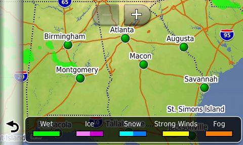
photoLive traffic cameras
This is a premium feature which costs $9.99 per year, but it seems like a very useful one to commuters. You can set it up to show your favorite cameras and then tap on one to see a full screen image. Here’s a link allowing you to check to see what traffic cameras are available in your area.


Basic weather
This free feature provides localized weather forecasts.


Advanced weather
Pay an extra $4.99 per year and you’ll get color-coded animated radar imagery and weather alerts.

Tracker
The free Tracker feature allows you to share your location via an emailed link, Twitter or Facebook. It has some nice flexibility built-in, allowing you to do things like customize how long you can be tracked. The flip side is that it is cumbersome. Garmin seems concerned (and rightfully so) about privacy issues, but they may have gone a bit overboard and made it needlessly complex.

As a result, I encourage you to play around with this feature and make sure you have it working properly before you depend upon it to send your location to anyone.

Your turn
Are you using Smartphone Link? Do you find it worthwhile? Have you tried the live traffic or fuel price services? If so, let us know what you think.
Garmin Smartphone Link review
June 11, 2012 By Rich OwingsLeave a Comment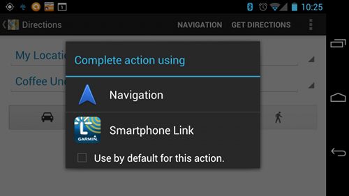 I’ve been living with Garmin’s Smartphone Link Android app for a few months now, and there are a lot of things I like about it. I haven’t tested all the features, but I’ll walk you through the ones I have tried.
About the Smartphone Link app
The Android app itself is available free from Google Play and Garmin is apparently looking into an iPhone version. It is compatible with newer nuvis with Bluetooth, which means you can use it with the nüvi 2475LT, 2495LMT, 2595LM, 2595LMT, 3490LMT and 3590LMT. You may need a firmware update for it to work with your model.
There are both free and premium features available within the app. Free ones include the ability to send a destination to the nuvi from your phone, basic weather, dynamic parking and Garmin tracker. Premium live services include traffic, photoLive traffic cameras, fuel prices and advanced weather.
Let’s look at a few of these in more detail…
Send a destination from your phone
This is definitely one of my favorite features, as it allows you to search for points of interest (POIs) from Google Maps on your phone (see images above and below) and send them to your nuvi. You can even plan trips ahead of time by starring a destination on your computer, accessing it in Google Maps on your phone and sending it to your nuvi. Best of all, this feature is free.

photoLive traffic cameras
This is a premium feature which costs $9.99 per year, but it seems like a very useful one to commuters. You can set it up to show your favorite cameras and then tap on one to see a full screen image. Here’s a link allowing you to check to see what traffic cameras are available in your area.


Basic weather
This free feature provides localized weather forecasts.


Advanced weather
Pay an extra $4.99 per year and you’ll get color-coded animated radar imagery and weather alerts.
Tracker
The free Tracker feature allows you to share your location via an emailed link, Twitter or Facebook. It has some nice flexibility built-in, allowing you to do things like customize how long you can be tracked. The flip side is that it is cumbersome. Garmin seems concerned (and rightfully so) about privacy issues, but they may have gone a bit overboard and made it needlessly complex.
As a result, I encourage you to play around with this feature and make sure you have it working properly before you depend upon it to send your location to anyone.
Your turn
Are you using Smartphone Link? Do you find it worthwhile? Have you tried the live traffic or fuel price services? If so, let us know what you think.
Monday, June 11, 2012
Blue2CAN for Fish and Mermaids
Sonar Bobber with Bluetooth - Android and iPhone Fish and Mermaid FInder
Friday, June 8, 2012
Wednesday, June 6, 2012
Google Geo - the Gosh-gollies?
Just how is ESRI doing these days? I can hardley wait for yet another UC for them in San Diego where we can put our buck down to help debug the next tread on their products?
As some of you may know Google Earth/Maps had an announcement today about their Earth and Map products. The under-current about this announcement is that given the rumor that next week Apple will also provide an answer to their community regarding their abandonment of Google Maps for a home-grown "Apple" mapping solution, no one even mentioned ESRI. Given the "rumorology" that seems to always bubble-up around the unknowns at Apple and its "geo" interests, well, the Apple-tweeters and others are looking to pull over anything that Apple challenges. So the most noteable that I have seen -
photorealistic 3-D mapping tech Apple acquired when it purchased C3 Technologies "old news"
or
Google announces that it is scared of Apple Maps "darned I hope my Apple solution is as good?"
But given that there now seems to be two giants taking real runs not just at the mapping app but at the entire ecology of map-making, well I have to wonder where Jack and friends may be? Seems that the July ESRI-ites clan gathering in San Diego may simply review 10.1 that was "supposed" to be released last Fall... just in time to become available for testing via its annual maintenance fees and agreements?
Esri has bought a company called Procedural that gives Esri now 3D content creation tools that are used in movies such as Cars 2. Clearly this is a huge move for Esri and could put them in markets they haven’t been in before. ArcGIS Runtime is new at 10.1 and is a new “MapObjects” type development platform. ArcGIS Online is an “open platform” for maps and geographic information. From desktop, to server to “cloud”. The thing about ArcGIS Online vs GEB is that Esri sees their analytic tools are their secret sauce that will take other companies year (if ever <>) to replicate. ArcGIS Online could be their standard geospatial analytical visualization engine moving forward. Nothing else is this deep or this usable. Sorry guys, Esri moved the bar way forward… << Who me worried? >> Jack says this Fall, you can host your maps in ArcGIS Online that you author in your ArcGIS Desktop content creation tools. 10.1 will integrate ArcGIS Online into the whole package. I get how this is critical for many organizations to integrate their Esri silo ArcGIS Server instances into company intranet websites. Esri is the link between their GIS Professionals and the world. 10.1 Beta will arrive in 2012 .... Spatially Adjusted - JUL 11TH, 2011
Wi-Fi solution for Nikon D4 by Nick O'Donnell

Wi-Fi solution for Nikon D4 by Nick O'Donnell:
Like most of you I love spending a boat load of money on things I won't be using very much. Yeah, right. The Nikon D4 is one heck of a camera with seemingly every capability the could stuff into it, including the wireless networking abilities of the WT-5. I purchased my D4 the day they were released along with the WT-5 and it's a great tool but not for that price. As a working pro I will get the use out of it to make it worth the $800 investment, but I periodically book events that I would like to have 3 or more cameras transmitting images to the server computer and buying extras for a couple shoots a year isn't worth it. On the other side, photographers that might want to have fun with what it can do without putting out the cash for real thing have been looking into other options. Here's my $44.16 solution:
I've purchased the Powerlink AP2403 on a tip from my best friend and host of the amazing website Technically Lexy. They were running a few days long deal to pick one up for $22 shipped free. The AP2403 is a very small, lightweight Router/Client/Access Point that can switch between these modes, plus it has a mini USB port for power which will be crucial for getting the setup portable. For this setup I'm using it in AP mode, that's basically taking the data from the Ethernet port on the D4 and turning it into a wireless signal to send to the server.
The other item is a $22.16 eBay purchase of a GearPower USB charger. This is normally used to recharge cell phones or iPods on the go. Important thing with this is the power comes from a mini USB port so we can power the AP2403. You may be able to use several other devices, one I have on order is called a Callpod, bought that also because there is much more battery capacity so I'll let you know how it goes.
Setting this up was pretty easy too. You will need a separate Wi-Fi network to get the AP talking with the computer. I plugged the AP2403 into the wall using the provided ac adapter and used my laptop to log into it while it was in router mode. If you have a computer with Wi-Fi, it should see it as the network MP01, that was the default for mine. I connected to it and opened Internet Explorer to type in 192.168.16.254 - this will open the settings. Then I changed the switch on the side of the AP2403 to "AP". That allowed me to see 'AP Client' in the wireless settings drop-down menu, select enabled and click apply. It will look for your Wi-Fi network when you click on 'site survey' you'll get a confirmation that it's connected to your Wi-Fi. The instructions that were included seem to be translated from Chinese or something because they were hard to read, but that should be all you'll need to do.
From there you'll be using the network settings in the D4 to connect, and your hardware settings will be using the wired network connections. The D4 doesn't know the wired connection isn't actually plugged in. Again, the AP2403 is essentially taking the signal from the wire and turning into a wireless signal. Since it's powered by a mini USB connection, the battery powers it perfectly. I've used it in HTTP mode and FTP mode and it works exactly as the WT-5 does. I'm using Cerberus FTP as my server program, it works like a charm. There are several free ones out there, but currently the WT-5 is incompatible with some of the free software out there. Of course using the HTTP setting in the camera to view and download images via a web browser is pretty easy too. I prefer running a server that can do some of the work for me. If you run a server you can send only the images you want. Combining the FTP software with a program like Hotfolder Prints from Breeze Systems will allow you to instantly print images sent from the camera, or you can use similar programs to show the images on a monitor to share with clients or friends. You can connect to your iPad or iPhone with an awesome app called ShutterSnitch, it's very user friendly and allows for rating of photos with a slick interface that lets you move between images quickly.
I've been looking at some mounting options for this setup too. I had a special plate added to a stroboframe flash bracket to hold the WT-4, of course that thing was huge so I don't need all that. I can see a simple use of Velcro holding the AP2403 and the battery to a small bracket that will attach to the tripod mount. I used to use Nikon's SK-7 to mount the extended range antenna for the WT-2 on my D2x. Another great thing I have is a brother-in-law that installs networks for a living so he can make me a cable a few inches long, so I'm hoping to mount it right off the side where the connection is maybe right in front of the sync port. Hope some of you out there can have fun with this and open up new doors for solving problems, or at least let the geek in you have a fun weekend project!
Feel free to leave comments if you have questions, I'll do my best to reply to them. I've also been chatting with many other users on dpreview on this topic in the D4 forums.
New vs Newer vs Benchmark Nikons

The D7000's body is just under a $1000 as is the D300s but the old D300s is getting a bit harder to find.
ESRI Rumors - Their Geodatabase ain't hunting...?
<< Note - not really certain how to attribute this as its a short collection of comments and pure opinion - found on a blog a few weeks back in regards to a Google around is "geodatabase is it really worth it?">>
Do I have an ArcInfo level licenses? No, I’m using ArcView.
The biggest blocker towards anything becoming the new shapefile is that ESRI charges $2,500+ for its "Data Interoperability" extension, which should be part of the core product. They aren't succeeding with geodatabase, but they are blocking the success of better formats. AnonymousUnless ArcGIS reads the format natively, without installing an extension (even free), it's not going to have the reach of a shapefile. And unless Esri truly opens the File Geodatabase spec like they did with Shapefiles, it's never going to succeed either.
When I do a quick Google search for “ArcGIS 10 Review” very few results appear that aren’t from Esri themselves.
Once again ARC is inconsistent with a process
You know, I totally agree, at least at an emotional level. My love-hate relationship goes back to the mid-90s. I’ve thrown in the towel a few times on ESRI, only to be sucked back in by the need to get something done that I couldn’t figure out how to do elsewhere given the time I had to do it.
The company should be shut down with the Feds going for an antitrust action against ESRI (monopolistic behavior). Then perhaps we can have some realistic competition in the field rather than having all legitimate competitors bought out – and then perhaps GIS will begin to reach its full potential rather than being hamstrung by a company that produces shit for software.
There- I had to say it. Almost 30 years of working with this company’s garbage products is too much. Imagine where GIS could be now if there was some real competition.
Subscribe to:
Posts (Atom)