Showing posts with label RouteScout. Show all posts

Thursday, July 4, 2013

KML FalconView - Joel keeps doing the very neat things... thanks

Introducing the FalconView KML Drawing Library


Thanks, Georgia Tech, for funding me to develop a library for drawing KML. The screen captures that you've seen in the last couple of months have shown the library in progress on Windows (via FalconView) and on Linux (via Quantum GIS).

O
One of the most exciting parts of this project was implementing a KML drawer for Android. This involved making the drawer and its dependencies (including Libkml and Google Test) compile using the Android native development kit, and hooking the Java-coded GUI to the C++ portion via JNI.

More information about the KML Drawing Library, which is used as a part of FalconView, may be found on the FalconView web site. Like all of FalconView Open Source, the KML Drawing Library may be used in third party applications so long as the terms of the FalconView Open Source license are followed. Some instructions for using the library and a link to the source code are available at that link. I'd be glad to answer questions about using the library posted here or on the FalconView web site discussion boards.

Tuesday, July 10, 2012

Portable Google Earth - When wires and radios fail

Written by Kevin P. Corble

Rapid Access Imagery
 
Industry Seeks New Ways To Deliver Imagery
And Derived Products More Efficiently To
Commanders In The Field Or Wherever
Geospatial Information Is Most Needed.
The U.S. defense/intelligence community has a seemingly insatiable appetite for commercial satellite imagery. The unclassified nature of images from private-sector remote sensing operators makes these products appealing to the military because they can be quickly transmitted between commands and freely shared among allied forces without the time-consuming clearances required for distribution of classified images.

While purchases by the Pentagon have been a boon to commercial satellite operators, these firms face the added challenge of staying ahead of the evolving needs of military end-users. In recent years, this has meant supporting the Department of Defense in finding new ways to deliver imagery and derived products more efficiently to commanders in the field or wherever the geospatial information is needed the most.

PORTABLE GOOGLE EARTH
The defense/intelligence community has embraced the Google Earth environment as one in which geospatial users with little or no formal training are comfortable viewing and accessing geographic information. The Google Earth Enterprise product enables customers such as NGA to build Web-accessible Google Earth Globes populated with their own data sets. In the military setting, this allows commanders to drill down through multiple levels of satellite and aerial imagery, as well as vector and video data, to gain 2-D or 3-D insights into nearly any area of interest on Earth.

Google and Spot Image teamed in 2008 to develop a portable and deployable version of Google Earth Globe for warfighters to take imagery with them on laptop computers or external drives where no Internet is available. Google Earth Enterprise Portable offers all of the same viewing and processing features as the larger product, but it is designed for use with smaller slices of the Globe, such as a single country or geographic region.

“The main advantage is that you now have imagery in the field in a completely disconnected version of the same, easy-touse, Google Earth,” said Sean Wohltman, a Google geospatial engineer.

With hard-drive space always an issue in mobile computing, Google looked for a medium- to high-resolution image product to serve as the base map for the portable Globe, recommending to customers the SPOTMaps line of products. These are fully orthorectified and color-balanced mosaics of recent 2.5-meter, natural color Spot imagery prepared as COTS products for specific countries and regions around the world. The mosaics are produced by Spot Image and delivered in the fusion-ready format compatible with the Google Earth environment.

Wohltman said the SPOTMaps products are the perfect base maps for the mobile application because the file sizes are relatively small for the amount of detail they contain, and Spot Image has already produced mosaics for many parts of the world. Availability of these mosaics in Google Earth formats eliminates weeks of processing and color-balancing for end-users who might otherwise try to create their own mosaics from individual scenes from other satellites, Wohltman added.

Tuesday, January 10, 2012

We've got movement... COT


Small 3lb Radar Changing the Game for Video Surveillance Systems

SpotterRF introduces an innovative small 3lb radar system for perimeter security and force protection.


“The M80 represents a game-changing solution for force protection. With this type of SWAP (Size, weight and power) it is now possible to get a miniature G-BOSS system in a backpack.”

Orem, UT (PRWEB) January 09, 2012


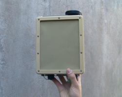
SpotterRF unveils production units of the M80 - a breakthrough small radar system that will revolutionize the world of military and commercial surveillance. The 3lb radar is roughly the size of a large paperback novel and has proven to accurately track moving personnel in range and angle out past a distance of 500m within a coverage area of nearly 40 acres.

The M80 is specifically designed to be employed by the individual warfighter to increase their situational awareness while in hostile territory when it is difficult to know what is taking place around them. Captain Dan Kearney aptly addresses the problem faced by small expeditionary units in the documentary, Restrepo. “While it’s pitch black and the helicopters can’t see anything, they can’t engage cause they don’t know who’s who. Airplanes can’t tell who’s who, Predators can’t tell who’s who, nobody knows what the hell’s going on.”

The U.S. Military has recognized the need for integrated force protection systems that include IR cameras and radar. Several heavy-duty systems have been developed such as the BETSS-C, used by the Army, and the G-BOSS, used by Marines, in an effort to support the surveillance needs of the warfigher. Each of these systems combines large radar (GSR) and high-power IR cameras to detect threats. While these large systems have proven to be effective in many areas such as forward operating bases (FOBs), many smaller groups in Combat Outposts (COPs) and firebases have been unable to use these large systems because of cost and support requirements.

The emergence of new technologies like miniature IR cameras from companies such as FLIR, RVision (a subsidiary of Cobham), Indigo Systems and General Dynamics, as well as small surveillance radars from Plextek and SpotterRF are making lightweight portable camera and radar systems a reality.

Logan Harris CEO of SpotterRF stated, “The M80 represents a game-changing solution for force protection. With this type of SWAP (Size, weight and power) it is now possible to get a miniature G-BOSS system in a backpack.”

As well as integration with current video surveillance systems, the M80 is capable of being a stand-alone surveillance option. Specifically optimized for deployment in more dense environments, such as locations near cities or other urban environments, the M80 provides live information of each moving target within it’s wide field-of-view. This information includes range, azimuth angle, velocity and location. The M80 outputs KML, JSON, as well as Cursor on Target data, an XML protocol developed by Mitre for the Department of Defense. Moving tracks of each target can be viewed on multiple platforms such as Google Earth or FalconView using any laptop or via a web browser on any mobile device.

The M80 can be quickly deployed using a standard CAT5 Ethernet cable, and calibrated for use in minutes with a built in web-based user interface. SpotterRF claims that the system is so easy to deploy that anyone who is familiar with using the Internet can setup and use the radar within 30 minutes. To aid in carrying less, the compact radar has a very low power consumption of 9W, and can run on a single BA 2590 battery for 17 hours.

SpotterRF is located in Orem, Utah, and is the industry leader in a new class of radar called Compact Surveillance Radar (CSR). To find out more please visit http://www.spotterrf.com.

Thursday, August 4, 2011

Garmin Innovation for Sports GPS

Garmin Connect Course Creator Nearly Ready 

Map and Export Routes to Garmin Sports GPS Devices


Garmin Connect Course Creator
I'm an enthusiastic user of the Garmin Connect site, which is
free, and has terrific logging and mapping features for athletes
using any of Garmin's wide range of sports GPSdevices. There
are a couple of things on my wish list for Garmin Connect,
however, including the ability to easily create a detailed road
route map and export it to a Garmin GPS device. Garmin
came close to granting that wish recently with the announcement
 and beta rollout of a newCourse Creator feature.

"With the new Course Creator, you will be able to quickly
and easily draw your course of choice laid over detailed
maps and know exactly how far you will be going," states
Garmin. "After creating your course, simply send it to your
compatible device and you are ready to embark on another
journey or epic workout."

The beta release had some bugs that will require the attention
of Garmin's programmers, so it has been temporarily
withdrawn from Connect. It's good to know this super-useful
 addition is nearly ready, and I look forward to reviewing
 it here.Image © Garmin

Tuesday, July 12, 2011

Droid Army gets their Handsets?


U.S. Army may soon equip troops with smartphones

Mark Milian
The drawdown of U.S. troops in Afghanistan begins this year, but remaining soldiers overseas may get smartphones.

This dry run has proved so encouraging that Army officials say they expect the first wave of smartphone-equipped soldiers could be shipped overseas later this year.


The drawdown of U.S. troops in Afghanistan begins this year, but remaining soldiers overseas may get smartphones.


(CNN) -- For U.S. Army troops, smartphones could become requisite field gear, along with boots, guns and ammunition.


The Army is wrapping up a six-week program to test the viability of using touchscreen phones and tablets in combat. The pilot program began on June 6 within the White Sands and Fort Bliss training areas in New Mexico and Texas.


Certain members of brigades are already assigned tactical radios. The phones wouldn't replace radios, but they would be distributed more widely and would ideally operate in conjunction with older equipment, officials said.


The infantry is using smartphones to text message updates about their surroundings, send pictures with an attached GPS location, pull up maps, and quickly fill out regular reports.


"When they have a problem or need to submit a report, they default to the texting," said Michael McCarthy, an Army director for the program. "These young soldiers grew up with this technology. They're very familiar with it. They're very comfortable with it."


Systems that tap a phone's camera and GPS to overlay information on an image of nearby surroundings, also called "augmented reality," is also in development, officials said.


In the trials, troops have collectively evaluated more than 300 Android, iPhone and Windows Phone units, McCarthy said. They are also kicking the tires on tablets from Apple, Dell and Hewlett-Packard, he said.


Separately, another Army division is testing phones running a specialized version of Google's open-source Android software, officials say. The prototype device is called the Joint Battle Command-Platform Handheld.


"We're looking at an assortment of devices," McCarthy said. "All the phones we've tested are pretty good."


A few devices have proved problematic, though. One popular phone from Samsung Electronics failed to connect to cellular networks and had bugs in its Android operating system, McCarthy said. So Sprint Nextel exchanged it for a different Samsung model, he said.


The Army group initially had some trouble testing the iPhone in the desert grounds, due to a problem many longtime owners of the popular Apple device know all too well. "AT&T didn't provide service there," McCarthy said.


Later, they were able to run the iPhone through its paces with the rest. "IPhone and Android have been very well received," said Ed Mazzanti, the Army director who has shepherded the mobile-device program.


Mazzanti expects the Army will anoint two mobile operating systems for official use. That way, they can minimize software development needs while still offering variety, which could defend against cyberattacks targeted at a specific type of software platform.


Army software engineers have developed a way for applications to be ported between the two platforms with minimal effort, officials said. Other apps are being coded as mobile-optimized Web pages, they said.


A spokeswoman for Google, which makes Android, declined to comment on the company's dealings with individual organizations. An Apple spokeswoman also declined to comment.


These glassy, metallic and plastic gizmos are astoundingly resilient, the Army's tests have found. They've weathered sandstorms and rugged conditions, despite the fact that many phones were bare and others protected by little more than $10 rubber cases, McCarthy said. (One, sadly, was run over by a truck and did not survive, he said.)


Soldiers can operate the devices' touchscreens using special off-the-shelf gloves.


Don't expect to see sergeants at Costco loading up shopping carts with electronics. But Army officials say that buying commercially available technology, rather than investing in research and production, is more economical.


"It's a lot cheaper for the Army to buy stuff that's already been developed than to develop it on our own," McCarthy said.


Many of the products sold at Best Buy are more advanced than the tools currently in the Army's pipeline. A smartphone, as texting fiends know, is not just a phone, Mazzanti said.


"It's a computer; it's a display unit; it's a video-out unit," he said. "Since it is a computer-based utility in a 7-ounce package, we just started realizing there was a vast amount of potential."


But obstacles remain before phones can be doled out to combat troops. The phones' software and their transmissions aren't fully secured.


"Today, we don't have the level of encryption that we would need to take (a phone) overseas and fully integrate it into our mission-command systems," Mazzanti said. Still, "there could be some limited deployments even this year, tied to tactical radios that supply the encryption that's needed."


In tandem with the smartphone and tablet program, the Army also is testing gear that allows operators to deploy a makeshift cell network. The "cell tower in a suitcase," which creates a limited-range wireless network, would be used when service is unreliable or likely to attract unwanted listeners.

Monday, July 11, 2011

DARPA and Full Motion Video - Show me the pain...

DARPA develops new tools to help process video data

Effort will help analysts detect activities and threats more quickly and easily
The constellation of ground-based and airborne sensors deployed by U.S. forces in Southwest Asia has been both a blessing and a curse. Although it allows warfighters to track and identify activities such as the planting of improvised explosive devices, the sheer volume of incoming data often works against them.
To control the information fire hose that wastes both manpower time and resources, the Defense Advanced Research Projects Agency has launched two related programs to provide warfighters with automated tools to quickly sift through large volumes of data. The Image Retrieval and Analysis Tool (VIRAT) and the Persistent Stare Exploitation and Analysis System (PerSEAS) are designed to identify and tag certain types of actions in raw video streams to bring them to a human operator’s attention.
“Bad guys do bad things, such as all the actions involved in burying an IED – so it is activity that matters," VIRAT and PerSEAS program manager Mita Desai said in a DARPA statement. "This is especially true when the bad guys look, dress and drive vehicles like those around them.” 
VIRAT is focused on full-motion video from platforms such as unmanned aerial systems and aerostats. It works in both forensic mode to identify activities in thousands of hours of archived, untagged data and in streaming mode. VIRAT focuses on identifying activities that are short in duration and take place in a small area. Algorithms from VIRAT support some of the underlying functions of PerSEAS.
PerSEAS is designed to observe multiple actions over a long period of time across a large geographic area to identify dangerous combinations and patterns of actions. This system will analyze data from platforms such as Constant Hawk and Gorgon Stare. According to DARPA, PerSEAS is undergoing additional research and development work before it is deployed for field testing.
“The objectives of VIRAT and PerSEAS are not to replace human analysts, but to make them more effective and efficient by reducing their cognitive load and enabling them to search for activities and threats quickly and easily,” Desai said.

Thursday, May 19, 2011


Eye Spy: Monocle Gives Commandos Drone Vision


TAMPA, Florida — Kyle Stanbro’s a big dude. Back when he was part of the elite Joint Special Operations Command, he weighed 250 pounds. When he had to strap on all his gear, especially the communications gear that patched him in to the watchful drones overhead, he added another 120 pounds. Not so good for jumping out of aircraft into the mountains of Afghanistan, as he’d brush up against the weight limits of his parachute.

In the early years of the Afghanistan war, much was made of how commandos on horseback called in airstrikes from the middle of nowhere. But the gear used for doing so was hardly ideal. Strapped onto Stanbro was a “coffee can” antenna and a receiver “the size of a bread box,” he recalls.

And if you wanted to see the video from a drone or a spy plane, you were in for a treat: You had a ToughBook attached to your chest plate, and you’d look down at the laptop screen for viewing a potential target. Because you might very well be running and shooting while watching drone footage — the ToughBook smacking you in the chest as you moved — you had to look away from the Talib spraying you with AK fire.

So when Stanbro retired from the military in 2004, he put his energies into shrinking everything down and making it lighter and more physically intuitive. It led him to build something called the Mover-IV. The foot-long black push-button device looks like a standard radio. In fact, it’s a receiver for real-time video that patches into an eyepiece to display the feed. Weighs just three pounds. He’s sold more than 100 of them to the U.S. Special Operations Command.


“[T]roops may have carried small, portable receivers that allowed them to watch the video feed being shot by an aircraft overhead,” Nathan Hodge wrote in the Wall Street Journal in an article about commandos’ access to digital imagery during the Osama bin Laden raid. “Some of those receivers look something like a rugged iPad; others can be worn, with small monocular screens that clip onto helmets.” Hodge is a Danger Room alum.

Stanbro (above) wasn’t part of the Abbottabad mission. So he can’t say how the SEALs watched video from the stealth drone overhead. But that’s throat-clearing.

“Coincidentally,” he says proudly, “that sounds very similar to this system right here.” His Galaxy tablet provides another display for the footage, one that can be velcro’d onto a vehicle dashboard.

For years, U.S. troops have been outfitted with a system called Rover, which was supposed to let infantrymen watch overhead footage on a tablet computer. In practice, the things were often too heavy and too finicky in the heat to bring on patrol.

Mover doesn’t have those issues. But it does share a flaw with Rover — and the whole drone-video-to-the-ground construct, as currently assembled. The video feeds are sent in the clear, unencrypted. Which means the footage could be intercepted by a clever adversary. (The next gen of Movers should provide a partial solution. It’ll be years before all the drones get encrypted transmitters, though.)
The eyepiece Stanbro selected for the Mover-IV is the Vuzix Tac-Eye, a lightweight high-resolution screen that attaches to a helmet and fits neatly over your non-dominant eye. (You want to keep your dominant eye free for shooting.)

Stanbro gestures to his partner, Clark Dever of Vuzix, who hooks up a camcorder to another Mover-IV and starts filming a hallway in the Tampa Convention Center, where the Special Operations Forces Industry Conference is in full effect. Stanbro hooks up the Tac-Eye to his Mover-IV through a standard six-pin connector and hands it to me.

As Dever moves the camera around, I see a group of businessmen behind me, chatting someone up on the virtues of their own defense-related product. They show up as dense, dark objects on a green screen. My other eye is free to see ahead of me, and my peripheral vision out of both eyes is clear. This may have been what it was like to keep one eye on the inside of bin Laden’s compound and the other on whatever the stealth drone picked up outside.

It works with more than drones. If there’s a manned spy plane overhead, the Mover-IV just needs the frequency or the band over which it securely broadcasts to receive the video feed, a process of pressing two buttons on the device. “Personal experience” got him several of those frequencies, he says.

Beats having a ToughBook on your chest. Or anything that would get in the way of your parachute opening.

Photos: Coastal Defense, Spencer Ackerman

Sunday, May 8, 2011

People Get Ready 3D is Here Pix4D

I have been watching these folks for a couple of years.  Like what you would expect from Swiss-Propeller-Heads (SPH) is nothing less than humbling.  Their kit last time I checked was $10k aprox. for the SensFly.  You have to stick to certain radio control frequencies and power limitations for the real-time corrections.  I could not discover the price of their 3D stiching solution described below. device.  


http://www.sensefly.com/


Management team


Chief Executive Officer
Jean-Christophe guides the strategic direction of senseFly. Since 2001, he has been pioneering the field of bio-inspired control for small autonomous flying robots. Jean-Christophe holds a Ph.D. in mobile robotics from EPFL, Lausanne, and a M.Sc. in micro-engineering with a master project completed at CMU, Pittsburgh. In parallel to his research, he followed a continuous formation in Entrepreneurship and Management. Since 2005, he has been involved in the management of various projects in aerial mobile robotics as group leader at the Laboratory of Intelligent Systems. He is also teaching mobile robotics at EPFL.
Head of Marketing and Sales
Andrea brings a broad experience of international markets and technical product management. She is member of the board since she joined the company in February 2010. Previously, she worked as Sales and Program Manager for RUAG Aerospace, a manufacturer of airplane structures. From 2006 to 2009 she was employed as Customer Support Engineer, Application Engineer and Program Manager at Vectronix, a manufacturer of observation, orientation and distance measurement devices. She holds a degree in Geodesy Engineering from the German University of Applied Science and Technology in Berlin.
Chief Technical Officer
Holder of a Ph.D. in micro-engineering, Antoine is an expert in aerial robotics and embedded software programming. Prior to founding senseFly, he was independent software developer and research assistant at the Swiss Federal Institute of Technology in Lausanne (EPFL), where he focused on the design and the control of micro-UAVs (unmanned aerial vehicles). His 10+ year experience in software and hardware development provides him with the technological skills required to bring micro-UAVs to a reality.

Saturday, May 7, 2011

Smartphones and DoD - Evolving Policy


Smart phones shape connectivity strategies, security programs

Widespread use of mobile devices poses myriad challenges for managers charged with protecting data
As handheld computers become more powerful and more common, they’re changing the way IT managers look at both connectivity and security. Smart phones, tablets and other compact systems can access networks from any location, making it much more difficult to limit access to networks.
The changes wrought by the emergence of these mobile devices was touched on by many speakers during the 2011 Department of Defense Intelligence Information Systems conference in Detroit. Many government agencies and private corporations once tried to prevent people from accessing secure networks using these systems, but most now realize that this is a losing battle.
“In today’s social media environment, people expect to have the similar tools and capabilities at home or when they’re on our network,” said Grant Schneider, CIO for the Defense Intelligence Agency.
Geoffrey Fowler, director and managing editor of the Worldwide Intelligence Review for the Central Intelligence Agency, expanded on that challenge. “If customers want to use these systems, they will find a way to use them. That’s why we need to make data available on all types of technology,” he said.
Including these devices poses myriad challenges for managers charged with protecting data. Matthew McCormack, the Defense Intelligence Agency's chief of cybersecurity, noted that while desktop and laptop users understand the need for security software such as antivirus programs, very few people use any type of protective programs on tablets or smart phones. If these devices hold malware, it can enter the network when they log in, he added.
That’s prompting management teams to devise new ways to protect data. Instead of preventing intruders from entering the network, they are now focusing on data protection. One technique is to limit the people who can access certain types of data.
“We’re moving to a concept where devices know who you are and what you need,” said Kelly A. Miller, Deputy CIO for the National Security Agency/Central Security Service. “We’re starting to protect data. In that model, you start losing classified protection boundaries and you start protecting data. That lets us move to a more mobile environment.”
Speakers noted that all these changes are necessary because decision makers want access to information whenever they have time to get it. They often do their analysis while they’re outside traditional offices or away from their home networks.
“Decisions are not always made when people are using their desktop PCs,” Fowler said.

Wednesday, April 27, 2011

Army going Wireless.. someday?


Army tests comprehensive plan for wireless services

Approach addresses security, apps issues for soldier smart phones
It’s been no secret that the Army has plans to issue smart phones to its soldiers. The service is also the lead agency in an effort to greatly increase wireless services, either through smart phones or tablet computers, across the Defense Department.
Speaking April 14 at a conference hosted by the Association for Federal Information Resource Management in Washington, D.C., a DOD official highlighted some of the aspects of the Army’s wireless efforts being managed through Army Knowledge Online, which runs the primary portal that allows Army personnel to access information from military networks.

Related Stories

In 2008, the Army wanted to expand AKO and looked at mobile applications as one solution, said Air Force Lt. Col. Anmy Torres, director of Secure Go Mobile at the Defense Information Systems Agency. Her group represents all mobile customers in the portal.
AKO examined how to put mobility into the portal with commercial applications. The service has already approved and certified Windows Mobile 6.5 and 7.0 applications for use, said Torres, who is the only Air Force officer on the AKO staff. Users also wanted iPads and other types of devices, she said. The Army is  negotiating with the other services for the broader use of wireless devices and applications.
The Army also is leading efforts to use commercial devices in DOD. One challenge is securing wireless devices. The service has been meeting since 2010 to mitigate security risks. The AKO can lock down BlackBerrys that have been lost or stolen and the goal is to now apply similar requirements for other handhelds, Torres said.
To support additional mobility, Army Go Mobile had to make changes to its back end by modifying its servers. One of the challenges facing the effort was the need for the system to identify specific mobile devices and applications. Because of security concerns, it was necessary to ensure that devices could not be compromised.
One of the AKO’s needs is to identify a device in the right price range that it can widely issue to personnel while ensuring security and integrity. Creating the back end for the system was the easy part, Torres said. The challenge is integrating in all the other tools, applications and devices within budget limitations.
The Army’s Go Mobile effort is now undergoing a limited deployment. AKO has teams trying to break into the system’s software container, an application that is encrypted and smart-card accessed on a soldier’s smart phone or tablet computer, Torres said. When a container is open, all other applications are locked down. When the container is closed, the device’s civilian applications can be used. If the device is compromised, it will not work because no container data is stored in the device.
Part of the limited deployment is a risk assessment effort. Security gaps exist in the Android and iPhone devices now in use, Torres said. The Army also is leading DOD with its testing and deployment of these devices, she added. The AKO helped DISA develop the Army’s Android standard, which will soon be ready for release.
Besides the Army, Torres said the Defense Advanced Research Projects Agency is working with other organizations in DOD to use iPads to replace the bulky notebooks officials use in classified meetings. DARPA removed the Bluetooth device in the iPad, which prevents them from transmitting data, but left the tablets otherwise unmodified.

Wednesday, April 6, 2011

Since 2009 - Offline and Lovin' It?

Using Google Earth Offline

Posted by FrankTaylor at March 31, 2009 8:20 AM

March 31, 2009

One of Google Earth's speed features also has the benefit of enabling the application's use when Internet is not available. The key is the Google Earth cache file which stores imagery and other data locally on your hard drive. This speeds up your experience even when you have broadband Internet, but it also is the secret to offline GE use.
By using the GE cache, you can still use most of Google Earth's features while on an African Safari, while driving your car, while boating offshore, or just camping on a mountain. This includes the aerial/satellite imagery, the 3D terrain, and more. And, the iPhone Google Earthapp has this feature as well. If you anticipate taking your computer (or iPhone) somewhere where you won't have an Internet connection, you can still use GE. Or you can use it for doing a demonstration somewhere without an Internet connection. You will need to do a little preparation first.

GE Cache Options

First, go to the menu item Tools->Options and select the "Cache" tab. You will not need to change the memory cache for viewing the cache (there is a trick for storing the cache with this setting - see below). The memory cache is set automatically based on your system's memory. You can make the disk cache size as large as 2000 MB (i.e. 2 Gigabytes). This will give you more data to work with. Then, you need to move to the area you want data for and zoom into that area. The most recent things you have looked at will be what's in your cache. It's important you zoom to the closest view you think you'll use. Turn on other layers for information you want cached (for example, 'Terrain', 'Roads' and 'Borders' - the more you select, the faster the cache wil fill). Also, make sure you save any KML files you might want to use in files on the same computer.
The more data you cache, the sooner the cache will fill, so be cautious. If you're going on a long trip, cache in high resolution imagery just the areas where you plan to use GE for close viewing. Avoid turning other layers if you only need imagery. It can be a pain to move around and capture an area of imagery at full high resolution and load up your cache properly. FreeGeographyTools has written some nice tutorials for some free tools for loading your GE cache in a more automated fashion - see hereherehere, and here. There is also a way you can save the cache files to extend the amount of area you can store (see this forum thread),
The GE offline capability can be really useful. I've used it personally for driving in a car, traveling by plane, and while sailing. There are still places without broadband or even cell phone connectivity. But, Google Earth can still work even in those remote places. Amazing!

Thursday, March 24, 2011

Garmin2575 Nuvi Video?

Garmin Nuvi 2575 with video recording


Garmin has a new new GPS navigation system coming out called nuvi 2575. We got the documents from FCC and it looks like the new 2575 and 2575R will support video recording with the help of an camera accessory. That’s not all though. Looks like this model will also come with analog TV with integrated antenna, an external TV antenna connector, and also support from FM TMC traffic receiver.
From some of the screen shots in the manual [pdf] we can see that this Garmin Nuvi may not be intended for US release plus we don’t do much analog TV here in the U.S. of A. – which kinda brings up the question: “why is this going through FCC then?”.
But either way you can expect some sort of Garmin Nuvi 2500 series device for the US market soon hopefully with the ability to record videos. Will this record videos with GPS information embedded? It sure didn’t look like from the manual. Don’t expect this to be a GPS car black box such as Black VueAce, or Mio.


GPS units have been hit hard these couple of years since pretty much all smartphones are capable of giving you driving directions and turn-by-turn directions with apps. Garmin’s nuvi 2575R has a twist to it that could give GPS devices a leg up. The new unit has an optional camera you can attach to it to record your driving.
Being able to record your driving could really help people out in those “he said, she said” situations when a car accident occurs. With video evidence of what happened it could really help, or hurt, your argument. The nuvi 2575R also comes with a TV tuner as well, which I guess is so that you can watch your favorite sports team while driving. That doesn’t make much sense, but I suppose that the resulting accident could at least be caught on the nuvi dash cam.
No price was given on how much the unit will cost you, or how much the extra camera will run you as well should you choose to attach it to the nuvi 2575R. This is definitely something a smartphone can’t do as your GPS directional unit, at least until some developer makes an app for it.


For those of you stateside though, I suspect we will see Garmin units with driving recorders a little later this year. If the 2575R model is any indication, we can expect a separate camera (pictured below), and you’ll probably need to pony up for an add-on subscription. You can hit up the FCC link for more info, but the boys in DC don’t keep their security certificates valid, so you can expect a big old warning from your browser.
Garmin-nuvi-2575R-camera
Add starShareShare with noteKeep unread