Wednesday, March 7, 2018

Wednesday, November 29, 2017
Daydream Impact
It’s one thing to read a news report about polar ice caps melting, but it’s another to hear the wind whipping against a towering glacier as you watch huge chunks of ice break off and tumble into the water below. With VR video, it’s possible to experience things that are rare or places that are far away or even impossible to get to. And short of actually being there, there’s no better way to understand the great challenges and opportunities of our world. Virtual reality can help people learn more and feel a part of important but distant problems.
Awareness is the first step toward driving social change, but organizations and changemakers often lack the resources or knowledge to use VR to shine a light on the causes they care about. That’s why we’re launching Daydream Impact to help organizations, creators, and changemakers make their programs even more powerful using virtual reality.
Daydream Impact focuses on three common bottlenecks we have identified: a lack of training on how to create VR video, difficulties accessing camera equipment and tools to showcase their content, and little exposure to how VR has been used creatively to tackle big challenges.
To help provide changemakers with training, we’ve created a VR filmmaking course on Coursera, which anyone can take. The course begins by outlining basic hardware requirements and pre-production checklists, and it shares tips for getting the best VR footage including best practices from other creators. The training also covers all the post-production work required to create the video and concludes with guidance on how to publish and promote the video.
Second, we’re launching a loaner program to give qualified projects access to equipment to capture and showcase VR pieces—this means a Jump Camera, an Expeditions kit, Google Daydream View and a Daydream-ready phone. Similar to our Jump Start program for creators, organization leaders will be able to apply for the program. Successful applicants will have six months to capture and refine their work and showcase it to their stakeholders.
Second, we’re launching a loaner program to give qualified projects access to equipment to capture and showcase VR pieces—this means a Jump Camera, an Expeditions kit, Google Daydream View and a Daydream-ready phone. Similar to our Jump Start program for creators, organization leaders will be able to apply for the program. Successful applicants will have six months to capture and refine their work and showcase it to their stakeholders.
- Harmony Labs partnered with media makers, researchers, and other experts to create three VR anti-bullying pieces and pilot these experiences in schools, ultimately creating a toolkit to highlight learnings about using VR for social impact.
- Springbok Cares worked with Daydream Impact to study how VR can reduce anxiety for cancer patients during treatment, and how to integrate large-scale VR programs into hospital environments. At the same time, they also launched a program to provide virtual reality entertainment to hospital patients and staff.
- Eastern Congo Initiative partnered with Daydream Impact to create a VR film and Expeditions that explore the struggles in the Congo and the resilience of its people. Through these platforms, ECI offers policymakers, donors and students an immersive experience and an emotional connection to the cause. By doing so, ECI believes that these partnerships, education efforts and advocacy will inform and inspire change for the Congolese people.
- The Rising Seas project and oceanographer Juliette Finzi Hart are leveraging 360 videos, depth maps and VR simulations to let people experience their future coastlines now, believing that allowing people to see the future they want to be will inspire them to take action—today.
We’ll share more on upcoming projects and case studies in 2018 with World Wildlife Fund & Condition One, UNAIDS, the International Committee of the Red Cross, Starlight Children’s Foundation, Protect our Winters, and Novo Media.
It’s our hope that Daydream Impact will help organizations tell their stories more effectively, or even change the way they operate, using VR. In a world full of information, virtual reality can help advocates inspire, connect, and bring change.
It’s our hope that Daydream Impact will help organizations tell their stories more effectively, or even change the way they operate, using VR. In a world full of information, virtual reality can help advocates inspire, connect, and bring change.
Monday, October 30, 2017
Trick-or-treat for Street View Frights!
Trick-or-treat for Street View Frights!
If you’re trick-or-treating on Halloween, you might see a ghost or two. But take this tour of haunted houses and spooky sites on Street View -- and the ghosts are no trick.
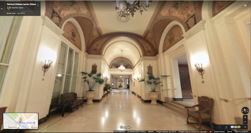
Our first stop is the Château Laurier, a 660,000-square-foot hotel that looms above the Ottawa River. Over the past 105 years, this architectural majesty has been graced by the likes of King George VI and Queen Elizabeth. But these dignitaries are not the only ones to walk its halls over the years … the restless spirit of business tycoon Charles Melville Hays has been known to appear. He commissioned the Château Laurier, but died tragically aboard the Titanic just days before the hotel’s grand opening in 1912. It's believed his spirit returned shortly after, and on occasion has been spotted roaming inside and out.
Our first stop is the Château Laurier, a 660,000-square-foot hotel that looms above the Ottawa River. Over the past 105 years, this architectural majesty has been graced by the likes of King George VI and Queen Elizabeth. But these dignitaries are not the only ones to walk its halls over the years … the restless spirit of business tycoon Charles Melville Hays has been known to appear. He commissioned the Château Laurier, but died tragically aboard the Titanic just days before the hotel’s grand opening in 1912. It's believed his spirit returned shortly after, and on occasion has been spotted roaming inside and out.
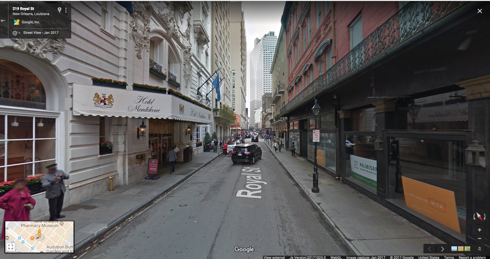
Head over to The French Quarter in New Orleans where both the living and dead are having a blood curdling good time. The soft sounds of jazz and the faint smell of beignets waft through the streets, but the dark side of this city is as rich as its melodies and cuisine—around every corner there are ghosts and vampires to be seen. Venture into Hotel Monteleone, where there have been many spooky sightings. This haunted hotel has a restaurant door that opens almost every evening then closes again (even though it’s locked) and an elevator that stops on the wrong floor, leading down a hallway that grows chilly and reveals the ghostly images of children playing. Stay there if you dare—you won’t know when to expect the next surprise.
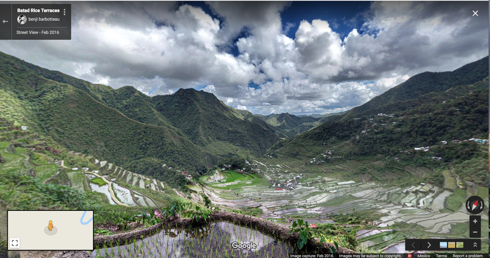
Now let’s head to the lush green paradise on Oman Island in the Philippines. Don’t let the beautiful landscape deceive you—this place has its fair share of spirits known to pester passers by. Local lore claims there are travelers who trek in circles, never finding their way out … and travelers have reported suddenly feeling weight on their backs, almost as if local ghosts are hunched on their shoulders.
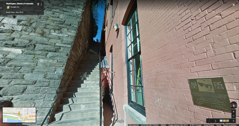
If iconic horror films are your jam, head on over to Georgetown, Washington, D.C., where the Exorcist was filmed. In “The Exorcist,” the character Father Damien Karras fell to his death down this flight of stairs (though they were padded with half an inch of rubber). The film crew had to construct a false front to the house from which Karras fell, since the actual house was set back slightly from the steps. When the filming took place, Georgetown University students charged people $5 each to watch the stunt from the school’s rooftops.
“Let the Right One In” is a Swedish film about a bullied 12-year-old boy who befriends a vampire child in Blackeberg, Stockholm, in the early 1980s. Check out the town square of Blackeberg
https://en.wikipedia.org/wiki/Blackeberg
, where Eli the vampire leaps down on Virginia from a tree.
https://en.wikipedia.org/wiki/Blackeberg
, where Eli the vampire leaps down on Virginia from a tree.

That completes our tour, but beware of spooky things of which you may not be forewarned— for this is Halloween!

Friday, October 27, 2017
Cat Phone - Tough Design and Massive Battery
Cat Phone - Tough Design and Massive Battery

NEW YORK, October 26, 2017 /PRNewswire/ --
Cat phones introduces the Cat S41, a rugged and resilient smartphone with a massive and powerful battery, designed to keep users connected no matter what challenges the day presents.
Key Specifications include:
- 5000mAh battery with up to 38 hours of 3G talk time or 44 days standby
- Charge other devices and accessories with the Battery Share power bank feature - cable provided
- Waterproof/Dust proof (IP68), drop tested to 5 feet 9 inches onto concrete, MIL SPEC 810G, Gorilla Glass 5 protected
- Android™ Nougat
- 3GB RAM, 32GB ROM. Expandable storage (microSD™ up to 2TB)
- MediaTek octa-core 2.3GHz chipset
- 13MP rear camera with LED flash, autofocus with PDAF, 8MP front camera - both with underwater mode functionality
- LTE Cat 6, VoLTE, VoWiFi
- Super bright 5" FHD display, optimized for outdoor use with a touchscreen that can be used with wet fingers or gloves
- Textured, extra grip design
- Programmable Shortcut Key useful for Push to Talk (PTT), SOS (Lone Worker app), or to easily launch flashlight or camera
- Curated apps and content catalog
The Cat S41 smartphone has an MSRP of $449 and is available to order online at http://www.catphones.com, as well as leading retailers including Amazon.com, BestBuy.com, eBay, The Home Depot and B&H.
Monday, October 16, 2017
Thursday, June 29, 2017
Wednesday, April 19, 2017
Friday, March 24, 2017
Keeping Touch... Maps of Position versus Relation?
https://blog.google/products/maps/share-your-trips-and-real-time-location-google-maps/
Share your trips and real-time location from Google Maps
Daniel Resnick
“Where are you now?” and “What's your ETA?” Whether you’re heading to a party or meeting up for dinner, you probably hear questions like this pretty often from family and friends. Soon Google Maps users worldwide will be able to answer those questions in just a few taps, without ever leaving the app. On both Android and iOS, you’ll be able to share your real-time location with anyone. And the people you share with will be able to see your location on Android, iPhone, mobile web, and even desktop. Here’s how it works in a real-world scenario:
Location Sharing in Google Maps
Whenever you want to let someone know where you are, just open the side menu or tap the blue dot that represents where you are. Tap “Share location” and then select who to share with and how long to share—and you're done! You can share your real-time location with your Google contacts, or even share with friends and family by sending a link on your favorite messenger apps. When you’re sharing your location, the people you’ve chosen to share with will see you on their map. And you’ll see an icon above the compass on your own map reminding you that you’re actively sharing your location. You can change your mind and stop sharing at any time—it’s entirely up to you.
Sharing Your Location
Next time you’re on your way or running late, you can share your real-time location and trip progress from navigation as well. During your next trip, tap the “More” button on the bottom on the navigation screen, and then tap “Share trip.” When you share your trip with people, they’ll see your expected arrival time and can follow your journey as you head toward your destination. Sharing automatically ends when you arrive.
Sharing a Trip
Location sharing on Google Maps is rolling out soon worldwide, and you’ll be able to quickly let your friends and family know where you are and when you’ll get where you’re going. The answer to “where are you?” is only a tap away.
Saturday, March 11, 2017
Planet - Your Daily Satellite Imaging Source
Planet, the global imaging company that recently acquired Google’s Terra Bella satellite imaging business, is introducing a new tool called Planet Explorer Beta that allows its users to view how its image captures of Earth from space change over time. It’s available to the public without a login, which means petty much anyone can check out what a particular spot on the planet looked like over a monthly or quarterly period.
Planet co-founder and CEO Will Marshall explains in a blog post that the company has noticed that, as it captures images of the same spots over time, almost all places undergo some visible change. Planet’s satellite network captures a lot more imagery than has typically been available, and on a more frequent basis — it can collect a new snapshot of every piece of land on Earth daily, via its network of 149 orbital satellites — and it says things change at least mostly almost invariably across the planet.
This company recently launched a couple dozen of micro satelites that allow imaging evey day everywhere. Quite amazing...
Great field management decisions depend on timely and accurate information, to identify problems before they impact yield. That's why Planet delivers data in near real time with a best-in-class automated pipeline, online tools, and easy-to-use formats. Now you can spend less time waiting for decision-making inputs, and more time taking action.
Use Planet APIs to seamlessly integrate your applications and workflows with our data
View your areas of interest multiple times during the growing season
Instantly access archived imagery (since 2009), to analyze and predict trends
Short Video of Montly Vegetative Index
Planet for Agriculture.... This is Worldwide... Even on your Cellphone!
There’s obviously a business aim with Planet’s decision to launch Explore Beta publicly with no login required — use of the resulting images is limited to non-commercial purposes, and Planet hopes this will drive free account sign-ups, which unlock access to not only monthly and quarterly change imagery, but also daily comparisons. And these hooks are likely to convert at least some users into paid subscribers, which allows them to use the available data for commercial use.
https://www.planet.com/

Planet, the global imaging company that recently acquired Google’s Terra Bella satellite imaging business, is introducing a new tool called Planet Explorer Beta that allows its users to view how its image captures of Earth from space change over time. It’s available to the public without a login, which means petty much anyone can check out what a particular spot on the planet looked like over a monthly or quarterly period.
Planet co-founder and CEO Will Marshall explains in a blog post that the company has noticed that, as it captures images of the same spots over time, almost all places undergo some visible change. Planet’s satellite network captures a lot more imagery than has typically been available, and on a more frequent basis — it can collect a new snapshot of every piece of land on Earth daily, via its network of 149 orbital satellites — and it says things change at least mostly almost invariably across the planet.
This company recently launched a couple dozen of micro satelites that allow imaging evey day everywhere. Quite amazing...
Great field management decisions depend on timely and accurate information, to identify problems before they impact yield. That's why Planet delivers data in near real time with a best-in-class automated pipeline, online tools, and easy-to-use formats. Now you can spend less time waiting for decision-making inputs, and more time taking action.
Use Planet APIs to seamlessly integrate your applications and workflows with our data
View your areas of interest multiple times during the growing season
Instantly access archived imagery (since 2009), to analyze and predict trends
Short Video of Montly Vegetative Index
Planet for Agriculture.... This is Worldwide... Even on your Cellphone!
There’s obviously a business aim with Planet’s decision to launch Explore Beta publicly with no login required — use of the resulting images is limited to non-commercial purposes, and Planet hopes this will drive free account sign-ups, which unlock access to not only monthly and quarterly change imagery, but also daily comparisons. And these hooks are likely to convert at least some users into paid subscribers, which allows them to use the available data for commercial use.
https://www.planet.com/

Monday, February 6, 2017
500 Strong... Where to next?
Remember when quadcopter drones juggled balls and formed up into a Star Trek logo? That seems downright quaint compared to what we just saw at Lady Gaga's elaborately produced Super Bowl halftime show. During her first number, 300 Intel drones formed the shape of an American flag, punctuating the singer's wire-assisted fall to the stage below.
https://www.engadget.com/2017/02/06/intel-drones-form-us-flag-for-lady-gagas-halftime-show/
Thursday, February 2, 2017
What is WebVR?

In the past year, Google has focused on making virtual reality a better user experience. At Google I/O 2016 the company introduced Daydream VR mode in Android Nougat, which is a far better VR experience than Google Cardboard ever was. Google is continuing this trend by adding WebVR support to Chrome, arriving in Chrome 56 as an origin trial.
WebGL, a subset of OpenGL that allows web pages to render 3D graphics, has been around for years. With WebGL and WebVR, web pages can create immersive 3D environments at high frame rates (if you have a decent device, that is).
Below is one of the demos, running at a smooth 60FPS on my Google Pixel once everything is loaded (the recording itself is not 60FPS).Viewing works equally well in all VR headsets - whether it's a Google Cardboard or a Daydream VR headset. Developers can also choose to use the Daydream controllers, Google Cardboard button, and other input devices as controllers.
While WebVR in Chrome 56 does not require enabling any flags in Chrome settings to use, the WebVR API is still under development, and as such the feature is marked as an origin trial. This means that websites have to whitelist themselves with Google to use the feature. If you have Chrome 56, you can try out some WebVR samples here.
While WebVR in Chrome 56 does not require enabling any flags in Chrome settings to use, the WebVR API is still under development, and as such the feature is marked as an origin trial. This means that websites have to whitelist themselves with Google to use the feature. If you have Chrome 56, you can try out some WebVR samples here.
Monday, January 2, 2017
Thursday, December 29, 2016
Bears Ears National Monument
|


Wednesday, December 28, 2016
AR via Google Earth Anyone? An Expedition to the Wild Far-off or Casual Stroll in Calcutta?

What is Expeditions?
Google Expeditions enable teachers to bring students on virtual trips to places like museums, underwater, and outer space. Expeditions are collections of linked virtual reality (VR) content and supporting materials that can be used alongside existing curriculum.
These trips are collections of virtual reality panoramas — 360° panoramas and 3D images — annotated with details, points of interest, and questions that make them easy to integrate into curriculum already used in schools.
Google is working with a number of partners, including: WNET, PBS, Houghton Mifflin Harcourt, the American Museum of Natural History, the Planetary Society, David Attenborough with production company Alchemy VR and many of the Google Cultural Institute museum partners to create custom educational content that spans the universe.
If you want to put together your own kit, you can use the app with Android tablets and phones. Expeditions will run on any Android (4.4 and above) or iOS (8.0 and above) device, but multiple devices are required to use the app. The phones used with a virtual reality viewer need to meet the required specifications.
Required specifications:
A gyroscope and accelerometer: This is essential for determining orientation and doing head-tracking in virtual reality viewer.
- Android 4.4 or later OR iOS 8.0 or later
- 1GB ram
Even if your phones meet the required specifications, some devices may still not be able to use Expeditions. For more certainty and a better experience, we recommend some additional specifications and features.
- GPU comparable with an Adreno 330
- High resolution screen: 720p or 1080p is recommended.
- Minimum of 2GB ram, 3 or 4 would be better
- 2.4ghz and 5ghz wifi support
- VR viewer compatible screen size (check the specifications for your viewer for recommended screen size)
Friday, December 16, 2016

Wednesday, November 2, 2016
DoD's Really Really Smartphone...
The NSA Chief Has A Phone For Top-Secret Messaging. Here’s How It Works

There’s no such thing as a perfectly secure phone, especially if it also connects to the internet. But leaving your phone on the plane every time you visit a hostile foreign country isn’t an option for everyone, and so a handful of top military commanders now have a device that can send and receive Secret and Top Secret messages. No surprise: it doesn’t work quite like the one in your pocket.
Developed by Boeing and the Defense Information Systems Agency, the Boeing Black phone has a dual-SIM card that “enables users to switch between government and commercial networks. Boeing Black integrates seamlessly into customer mobile device management systems and virtual private networks,” according to the product data sheet.
One of the recipients is Cyber Command chief Adm. Michael Rogers, said DISA head Lt. Gen. Alan Lynn.
That’s not to say that everyone in the military can expect to receive one. “The Boeing Black is the device we’re currently working with,” Lynn said. “We’re just now in the test phase,” he said.
That the military has been working on such a device is no secret. A lot of device manufactures have been eager to meet rising military needs for secure communication. One contender, Silent Circle, co-founded by encryption guru Philip Zimmerman and former Navy Seal Mike Janke, has managed to push a few units into the hands of some military for testing and recreational use.
Lynn said the Boeing Black phone also works with “a large amount of encryption.” But the encryption alone is not what makes the device so secure. “There’s nothing that lives on the devices,” said Lynn. “It’s close to a VDI,” a virtual desktop infrastructure.
What that means is that the most secure phone in the world is, in the purest since, just a window to another computer, a remote server on the military’s Top Secret JWICS network. That server does all the real work and holds the data. The phone itself just moves input commands — keyboard, mouse, and other signals — to that server. The result, said Lynn: “We’re not too worried about losing data,” at least not off the phone.
But does Rogers like the phone? Lynn said, “I think he does. Haven’t heard any complaints.”
There’s no such thing as a perfectly secure phone, especially if it also connects to the internet. But leaving your phone on the plane every time you visit a hostile foreign country isn’t an option for everyone, and so a handful of top military commanders now have a device that can send and receive Secret and Top Secret messages. No surprise: it doesn’t work quite like the one in your pocket.
Developed by Boeing and the Defense Information Systems Agency, the Boeing Black phone has a dual-SIM card that “enables users to switch between government and commercial networks. Boeing Black integrates seamlessly into customer mobile device management systems and virtual private networks,” according to the product data sheet.
One of the recipients is Cyber Command chief Adm. Michael Rogers, said DISA head Lt. Gen. Alan Lynn.
That’s not to say that everyone in the military can expect to receive one. “The Boeing Black is the device we’re currently working with,” Lynn said. “We’re just now in the test phase,” he said.
That the military has been working on such a device is no secret. A lot of device manufactures have been eager to meet rising military needs for secure communication. One contender, Silent Circle, co-founded by encryption guru Philip Zimmerman and former Navy Seal Mike Janke, has managed to push a few units into the hands of some military for testing and recreational use.
Lynn said the Boeing Black phone also works with “a large amount of encryption.” But the encryption alone is not what makes the device so secure. “There’s nothing that lives on the devices,” said Lynn. “It’s close to a VDI,” a virtual desktop infrastructure.
What that means is that the most secure phone in the world is, in the purest since, just a window to another computer, a remote server on the military’s Top Secret JWICS network. That server does all the real work and holds the data. The phone itself just moves input commands — keyboard, mouse, and other signals — to that server. The result, said Lynn: “We’re not too worried about losing data,” at least not off the phone.
But does Rogers like the phone? Lynn said, “I think he does. Haven’t heard any complaints.”
Thursday, September 29, 2016
Is that a Mesh in your Pocket?

Send text messages and share GPS locations on offline maps with others. Chat privately in 1-to-1 or group conversations, or broadcast to any other goTenna Mesh device up to several miles or kilometers away all without using towers, routers or satellites.
Each tiny-but-mighty device is powered by game-changing networking protocols which intelligently — and privately! — relay messages through other users. You can potentially double or triple any device's effective range and create a network that gets stronger the more people join it!


Pair wirelessly to your phone

goTenna Mesh pairs seamlessly to smartphones via Bluetooth-LE (Low Energy, 4.2), with minimal smartphone battery usage. (In fact, you can even turn your phone into Airplane Mode to preserve its battery, as goTenna Mesh will still work. Just remember to toggle Bluetooth on!)
Super-smart protocols enhance functionality & make it easy for you to use

Using the goTenna app, send private 1-to-1 and group chats as well as broadcast to anyone within range. Count on delivery confirmation receipts, and easily download free, detailed offline maps of the entire world before you go off-grid. You’ll never have to worry about interference or channel-switching, the way you do with analog walkie-talkies. Radio + smartphone = intelligence!
The freedom to communicate over great distances, no service required

(goTenna Mesh uses publicly available spectrum, intelligently selecting frequencies that are available in your region.)
Revolutionary mesh networking technology (the future is now!)

Here's a demo that helps explain how meshing works, using prototypes & phones in Airplane Mode. Because transmissions between goTenna Mesh devices are literally invisible, we've added voice-over to explain what's happening:
(Fun fact: Our mesh protocol is called Aspen Grove, named after aspen tree colonies which share a common root structure that can expand over huge areas, and is resilient enough to survive harsh forest fires. Like a mesh network, aspen trees find strength in numbers and grow from the bottom-up.)


Outdoors
Keep in touch with those you spend time outdoors with, from hiking to skiing to fishing, and just about anything in between. Travel
No more expensive roaming fees or international SIM cards — simply use goTenna to stay connected with your travel-mates on trips abroad.
Crowded Events
Enjoy the crowd without getting lost in it — avoid overwhelmed cell towers at packed festivals and crowded events and stay in touch with your group.
Emergency Situations
Exchange critical communications with friends and family as well as others nearby during emergencies, even when the power is out and cell towers are down.
Sunday, September 11, 2016
Amazing Light Gimbals Under $1,000 for 5-axis and up to 1.6 kg (3.5 lbs)
The Nebula will be available in 3 versions, Lite (one handle) Pro (dual handle) and 5-axis stabilizer version (dual handle with spring section for vertical axis). You’ll be happy to hear that all will retail at under $1k: $799, $899, and $999 respectively.
https://www.cinema5d.com/nebula-4200-5-axis-stabilizer-preorder/
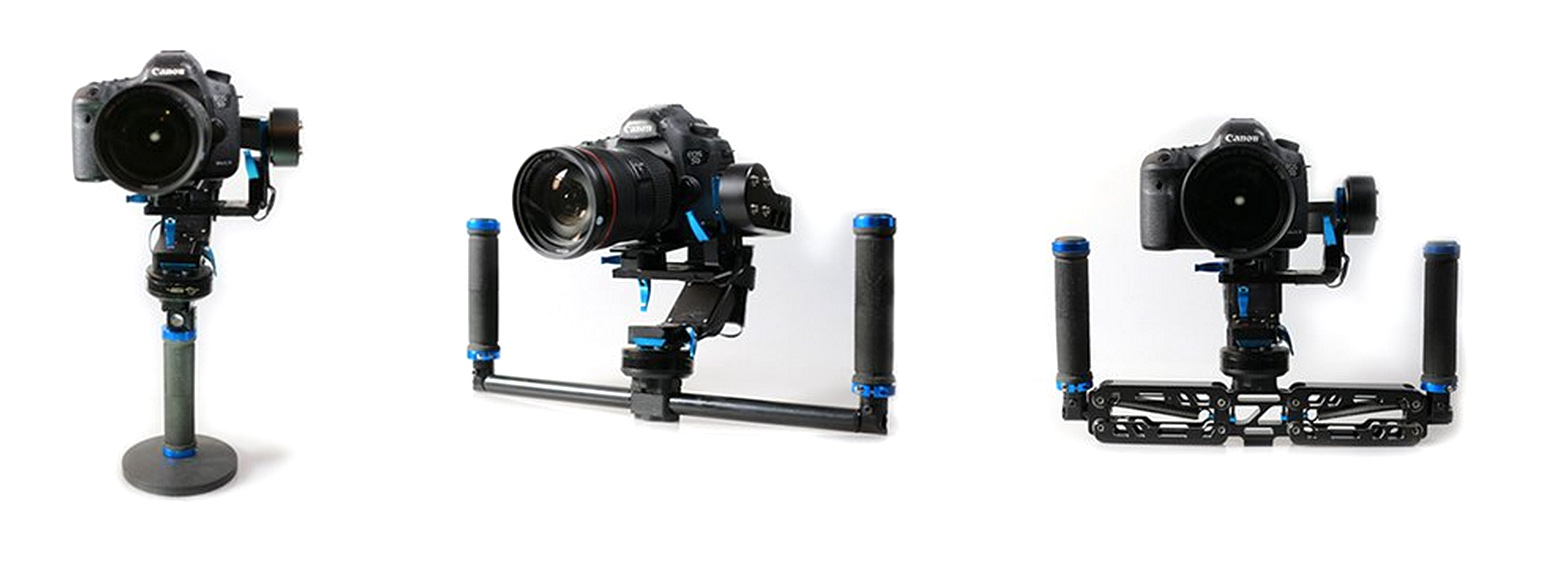
https://www.cinema5d.com/nebula-4200-5-axis-stabilizer-preorder/
Author of this post: Tim Fok
Tim Fok is a freelance DOP & Filmmaker based in London, UK. Carrying over a decade of experience, he specialises in brand, commercial, creative corporate, and documentaries.
Saturday, September 10, 2016
Friday, September 9, 2016
Date with Karma ...
On 9/8/2016 6:43 PM, gary wrote:
Hi Neil, Ken, Topher,
The GoPro UAV announcement coming soon, if this teaser video is any way believable it implies that the device is very small and completely silent ? - https://youtu.be/6831JUHz_Wc
Regards Gary
Gary -
Gary -
I saw the teaser too, fun to speculate on what exactly they will be introducing. The sound does seem to be the "big thing", but stability is also pretty remarkable. Considering what "might be" perhaps they have mounted an IMU on board and are recording the motion of the camera in order to process out the shake, instead of trying to remove it entirely from the camera "platform" (drone) or whatever it might be. Also the platform must be pretty unobtrusive as it does not seem to bother people or cause their hair to blow around etc. Regarding the sound, perhaps they have discovered a way to "cancel" the sound from propellers? If so, it's a damn good implementation because the sound is (apparently) perfectly clean. They have obviously stuck with a very wide angle lens...
Ken
Ken, Gary, and Toph -
Also saw this... Neil

Also saw this... Neil

By Sean O'Kane on September 9, 2016 03:00 am
Sony has announced a new version of its very capable GoPro competitor, the 4K Action Cam. The new model, called the X3000R, costs $400 and has a slew of new features like optical image stabilization, face detection, and the revamped menu system that we first saw on the smaller Action Cam announced at this year’s CES. Sony also announced the $300 AS300R, which has essentially all the same features except it tops out at 1080p. Both cameras will be available later this month.
Sony’s Action Cams have had digital stabilization for years now, so it’s great to see that the company finally found a way to build optical, or mechanical, image stabilization into this model. Digital stabilization is software-based — it smooths out footage by cropping in on the image and using the excess space to adjust for vibrations, so the results are not always good.
Mechanical stabilization involves physically moving some of the lens elements and the image sensor, which can produce better results without losing as much of the image to cropping. With almost every action camera capable of shooting 4K, image stabilization feels like it will be the next defining feature for action cameras. In fact, Garmin announced a new Virb action camera last week that uses electronic image stabilization, but while I was really impressed with it, I’d take optical image stabilization any day.
That’s not the only new thing about this model, though. Sony built a new lens for these Action Cams, which is supposed to produce an image that isn’t quite so distorted as it was in past versions. They'll also be using a new version of Sony's Exmor R CMOS image sensor, which is now back-lit. And Sony’s including the new menu system that it launched on the smaller Action Cam earlier this year, which is good, because the menu on the old 4K Action Cam (and all the models before it) was awful. The new screen serves up more information at a glance and it no longer takes you a dozen taps to change modes or settings.
Sony has announced a new version of its very capable GoPro competitor, the 4K Action Cam. The new model, called the X3000R, costs $400 and has a slew of new features like optical image stabilization, face detection, and the revamped menu system that we first saw on the smaller Action Cam announced at this year’s CES. Sony also announced the $300 AS300R, which has essentially all the same features except it tops out at 1080p. Both cameras will be available later this month.
Sony’s Action Cams have had digital stabilization for years now, so it’s great to see that the company finally found a way to build optical, or mechanical, image stabilization into this model. Digital stabilization is software-based — it smooths out footage by cropping in on the image and using the excess space to adjust for vibrations, so the results are not always good.
Mechanical stabilization involves physically moving some of the lens elements and the image sensor, which can produce better results without losing as much of the image to cropping. With almost every action camera capable of shooting 4K, image stabilization feels like it will be the next defining feature for action cameras. In fact, Garmin announced a new Virb action camera last week that uses electronic image stabilization, but while I was really impressed with it, I’d take optical image stabilization any day.
That’s not the only new thing about this model, though. Sony built a new lens for these Action Cams, which is supposed to produce an image that isn’t quite so distorted as it was in past versions. They'll also be using a new version of Sony's Exmor R CMOS image sensor, which is now back-lit. And Sony’s including the new menu system that it launched on the smaller Action Cam earlier this year, which is good, because the menu on the old 4K Action Cam (and all the models before it) was awful. The new screen serves up more information at a glance and it no longer takes you a dozen taps to change modes or settings.
Subscribe to:
Posts (Atom)