Introducing “Views” - A new way to contribute your 360° photo spheres to Google Maps
Wherever life’s adventures may take us, our photos help us remember and share the places we care about. When photos are added to a map, whether they’re from your camera or through Street View, they record unique experiences that collectively create the story of a place and what it looked like at a particular moment in time.
Today, we are launching a new community site called Views that makes it easy for people to publicly share their photos of places by contributing photo spheres to Google Maps (photo spheres are 360º panoramas that can be easily be created with your Android phone).
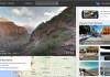
Below is a screenshot of the new Google Maps for desktop, showing a photo sphere that I shared one morning in Hawaii while my wife and I walked along the beach near our old neighborhood. The thumbnails at the bottom show our comprehensive photo coverage, with each image accurately placed on the map.

A photo sphere in the new Google Maps. Can you feel the sand between your toes?
Photo spheres can be created with the camera in Android 4.2 or higher, including most Nexus devices and the new Nexus 7 tablet. This short video will show you how to get started. You can also share panoramas you’ve created with your DSLR camera (learn more on our help center).
To upload 360º photo spheres, just sign into the Views site with your Google+ profile and click the blue camera button on the top right of the page. This will enable you to import your existing photo spheres from your Google+ photos. You can also upload 360º photo spheres to Views from the Gallery in Android by tapping “Share” and then selecting Google Maps.
Below you can see my Views page, which is filled with photo spheres and descriptions about my experiences in the places I’ve visited. I created these during my travels, including day trips and hikes around the San Francisco bay area, as well as far away adventures to Hawaii, Sydney, Beijing, andParis. Sometimes I also share photo spheres around the Google campus in Mountain View. You can explore them all on this map.

Screenshot of my Views page
Since Views also incorporates the Street View Gallery, you can check out incredible panoramas of our most popular Street View collections, from theGrand Canyon to the Swiss Alps. Just click on “Explore” at the top of the Views site to browse a map of these special collections right alongside community-contributed photo spheres.
So, when you’re on your next adventure, don’t forget your camera and your Android phone to create and share some photo spheres of places that inspire you... we can’t wait to see them!
View Larger Map
Posted by Evan Rapoport, Product Manager, Google Maps & Photo Sphere
Google Rolls Out New “Views” Site For Geotagging And Sharing Your Android Photo Spheres
If you’ve got an Android device running version 4.2 or later, chances are you’ve tried capturing a photo sphere — one of those nifty little 360-degree panoramas that let you spin around to capture your surroundings until vertigo sets in. Instead of just letting those photo spheres languish on your phone or on your Google+ account, though, Google has thought up something awfully keen for them.
You know what I’m getting at (the headline was probably hint enough). Google has fired up a new Views page that lets users tie their photo spheres to specific locations for when static maps and satellite fly-bys just aren’t immersive enough.
The process is simple enough: once you’re logged in to Google+ and mosey over to the Views page, you’re given the option to import all of the photo spheres stored in your Google+ account. Haven’t uploaded them to Google+ yet? That’s fair — you can upload them to Google Maps straight from the stock Android gallery app, too. Google Product Manager Evan Rapoport also confirmed that users who share those photo spheres will also be able to view them from their own Views user page, which looks a little something like this. As you’d expect, you’ve got easy access to a grid of all your photo spheres, but a single click lets you pull out into a wider map view to see where all of those spheres were captured.
It’s all rather neat, but to be quite honest it’s about time Google managed to make the whole photo sphere experience meatier. Sure, they’re easy enough to shoot, and the end results are generally pretty impressive, but users were always fairly limited with what they could do with those photo spheres after the fact. At least now users who have dedicated themselves to creating awesome photo spheres (I’m sure there are more than a few people who fall into that category) have a centralized spot to show off some of their most impressive work. Of course, it’s not hard to see how Google benefits from this.
As intrepid as Google’s crew of drivers and trekkers are, there’s only so much in terms of resources the company can devote to making the world’s varying locales accessible from a web browser. Now that it’s easier for folks to share their photo spheres, Google could theoretically serve up on-the-ground views of any (human-accessible) location by displaying those photo spheres in Google Maps proper. I wouldn’t expect Google to try anything quite that bold until Android 4.2′s adoption figures swell a bit, but it’s certainly something to keep an eye out for.
No comments:
Post a Comment